
On Haida Gwaii, a colonial government is no longer lord of the land
British Columbia and the Haida Nation’s historic agreement recognizes Haida land ownership across the archipelago...

This article also appears on Policy Note.
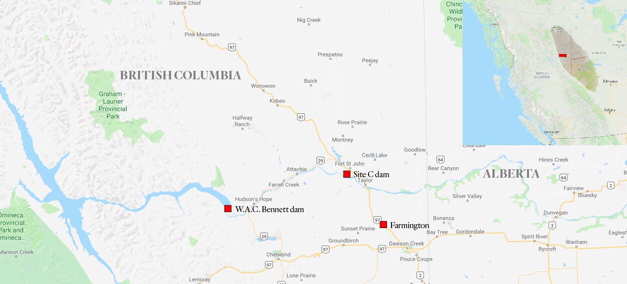
BC Hydro officials were so alarmed by an earthquake that shook the ground at its sprawling Site C dam construction project in late November, they ordered a halt to all work and got on the phone to British Columbia’s Oil and Gas Commission (OCG).
The 4.5 magnitude earthquake was linked to natural gas company fracking operations and was among the most powerful to rock the region in recent years.
And it raises questions about what other infrastructure — bridges, schools, hospitals, to say nothing of homes — may be at risk from fracking operations.
Site C is the most expensive public infrastructure project in British Columbia’s history.
Its estimated costs have ballooned to $10.7 billion partly due to delays during early work phases when “tension cracks” opened on the partially excavated slopes along the river. The slopes are notoriously unstable as underscored by a spectacular landslide last fall that threatened the community of Old Fort, just downstream from the dam construction site.
The earthquake began at dusk on November 29 and was felt throughout the Peace region. It shook residents at their dinner tables in communities from Charlie Lake to Pouce Coupe nearly 100 kilometres southeast and points in between including Hudson’s Hope, Fort St. John, Taylor, Dawson Creek, Farmington and Chetwynd.
BC Hydro told the Canadian Centre for Policy Alternatives (CCPA) that it ordered workers at Site C to down tools when the quake began and that a conference call took place early the next morning between BC Hydro and Oil and Gas Commission officials.
During the call, the commission, which approves all oil and gas industry activities including fracking, shared details on the quake that would not become general knowledge until days later.
“The Oil and Gas Commission provided BC Hydro with its initial findings, which included the earthquake’s epicentre, magnitude and peak acceleration measurements from one nearby instrument. The OGC also informed us that two [natural gas] wells were in operation at the time of the earthquake and that those operations were immediately suspended,” BC Hydro spokesperson Mora Scott wrote in emailed responses to questions from the CCPA.
Scott went on to say that the two wells were “in the process” of being fracked when the earthquake began and were located on a large “multi-well” pad where numerous gas wells had been drilled prior to fracking by Canadian Natural Resources Ltd. (CNRL).
The two CNRL wells were identified as “G” and “H” and were located “about 20 kilometres from Site C,” Scott said.
BC Hydro and the Oil and Gas Commission mutually agreed three years ago to limit fracking within five kilometres of Hydro’s Peace River dams and reservoirs, out of concern they could be damaged by brute-force fracking operations, which involve pumping immense amounts of water, sand and chemicals into the earth to “liberate” trapped natural gas and oil.
The November earthquake occurred in the “Lower Montney,” the most actively drilled and fracked region in northeast B.C.
Parts of the Montney are rich in condensate, a liquid that flows to the surface along with natural gas following fracking and that is used by Alberta oilsands companies to dilute unrefined bitumen so that it can be piped to refineries.
From the early spring of 2017 through the winter of 2018, farming families in the rural enclave of Farmington near where CNRL and other companies frack experienced five “felt events” — commission jargon for earthquakes that shook residences.
Map: Carol Linnitt / The Narwhal
In May 2018, following that cluster of fracking-induced earthquakes, the commission issued an “industry bulletin” instructing fracking companies operating near Farmington to follow new rules. The area was rechristened “the Kiskatinaw Seismic Monitoring and Mitigation Area.” The Kiskatinaw River is nearby and is a major source for the water used in local fracking operations.
The new rules anticipated that more earthquakes would occur and that more risks likely lay ahead.
Rather than embrace the precautionary principle and exclude fracking operations from occurring nearby local farms and homes, the Oil and Gas Commission opted to try to manage the risks instead by requiring companies to immediately halt any fracking operation if it triggered a magnitude three or greater earthquake. After that, no fracking could resume “without the written consent of the Commission.”
In response to questions from the CCPA, the commission said that the suspension of CNRL’s fracking operations remains in effect, nearly four full months after the November earthquake.
“CNRL’s hydraulic fracturing operations targeting the lower Montney formation within the specified area remain suspended pending the results of a further detailed technical review,” wrote Lannea Parfitt (no relation to the author), the commission’s manager of communications.
“CNRL cannot resume operations targeting the lower Montney formation without written consent of the Commission.”
Parfitt said that CNRL was the only fracking company ordered to suspend operations, while other companies volunteered not to frack “for a period of 30 days” following the earthquake and pending the commission’s initial investigations.
“BC Hydro was consulted immediately after the event,” Parfitt added, and “all information pertaining to the November 29th event was transmitted to BC Hydro for their analysis.”
Jim and Pat Strasky live in the Farmington area with their son, Liam. After one “felt event” prior to the big shake of November 29, Jim discovered a crack in the foundation of the family home.
The Straskys have witnessed major changes to the landscape around their multi-generation farm. In recent years a handful of large gas processing plants have been built on fields that once grew wheat and canola crops. Elsewhere, wheatfields have been dug up to make way for giant water pits or large earthen dams to corral water used in fracking operations. Compressor stations and flare stacks are also common sights and a daily reminder of the industrialization of the landbase.
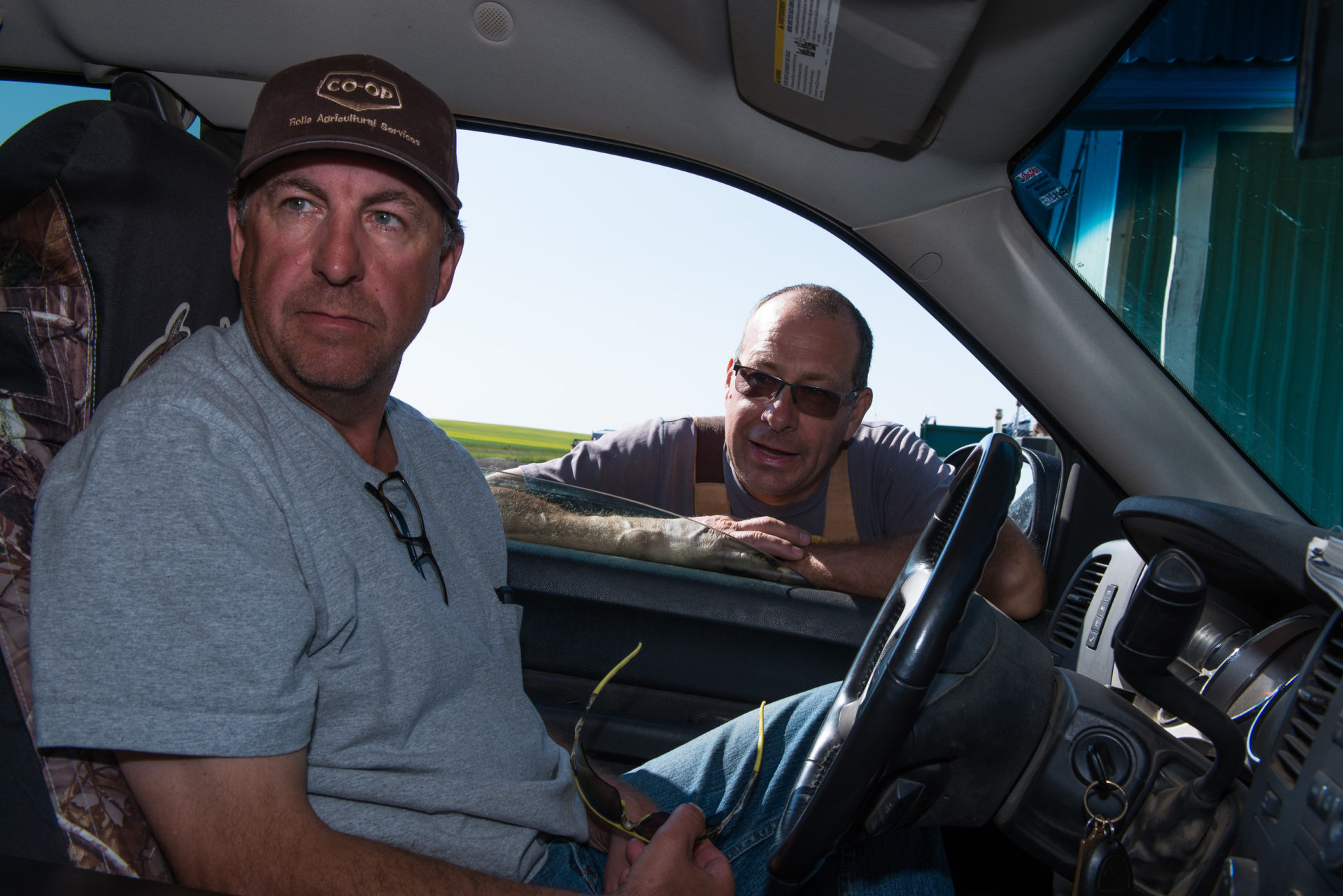
Jim Stratsky, who discovered a crack in the foundation of his home after an earthquake, pictured here with his brother near oil and gas operations in the Farmington, B.C., area. Photo: Garth Lenz / The Narwhal
Liam was at home on November 29, Pat said in an interview.
“He was in the basement and he said the whole house just shifted, moved over. Everyone in the community felt it,” she said.
Pat added that “no one was pleased” with the shaking, particularly because it happened so close on the heels of a spectacular explosion at a gas pipeline near Prince George the previous month. The explosion and ensuing fire forced the evacuation of approximately 100 people. Footage of the inferno generated great unease in the Farmington area, Pat said, explaining that just about every farmer in the region has one or more pipelines running beneath their fields.
Some of those lines carry sour gas or gas containing the powerful neurotoxin hydrogen sulfide. People breathing sour gas can be knocked unconscious instantaneously and killed if the hydrogen sulfide content exceeds just 500 parts per million.
Could earthquakes rupture such lines? Pat asks. And if they could, what would that mean for local residents, including students at nearby Parkland Elementary school? Pat used to work at the school where she recalls one of the tools in the “emergency” toolkit being duct tape to seal doors and windows in the event of a sour gas leak.
Since the November 29 induced earthquake, investigative journalist and award-winning author Andrew Nikiforuk reported on an even more powerful induced 4.6 magnitude tremor near Red Deer, Alberta and on a induced 4.9 magnitude earthquake in China that may have killed four or more people.
The morning after the November earthquake, BC Hydro conducted “safety inspections” at Site C “to ensure the stability of all construction work and the safety of all site personnel before any construction resumed,” Scott said, adding: “Our inspections determined that no damage occurred on site as a result of the earthquake. We also have instruments that monitor the performance of excavations and other earthworks, and that did not record any changes or damages on site.”
About the same time the earthquake occurred, Michelle Mungall, B.C.’s Minister of Energy, Mines and Petroleum Resources, received a copy of a draft report from a three-person “science panel” that she appointed last March to examine a limited number of issues associated with fracking including induced earthquakes and the gas industry’s impacts on water resources.
The panel’s report was released Tuesday and flagged numerous concerns about the uncertainties associated with fracking.
The word “unknown” is mentioned 34 times in the document. The unknowns flagged by the panel include just how large a magnitude earthquake could be triggered by a fracking operation.
“The very rapid development of the shale gas in NEBC [Northeast B.C.] has made it difficult to assure that risks are being adequately managed at every step. Furthermore, the Panel could not quantify risk because there are too few data to assess risk,” the panel said.
The panel flagged that “now is the time to proactively address” the unknowns because of a planned Liquefied Natural Gas or LNG plant in Kitimat, which will dramatically increase the need for more natural gas drilling and fracking.
The provincial government strongly supports the LNG project.
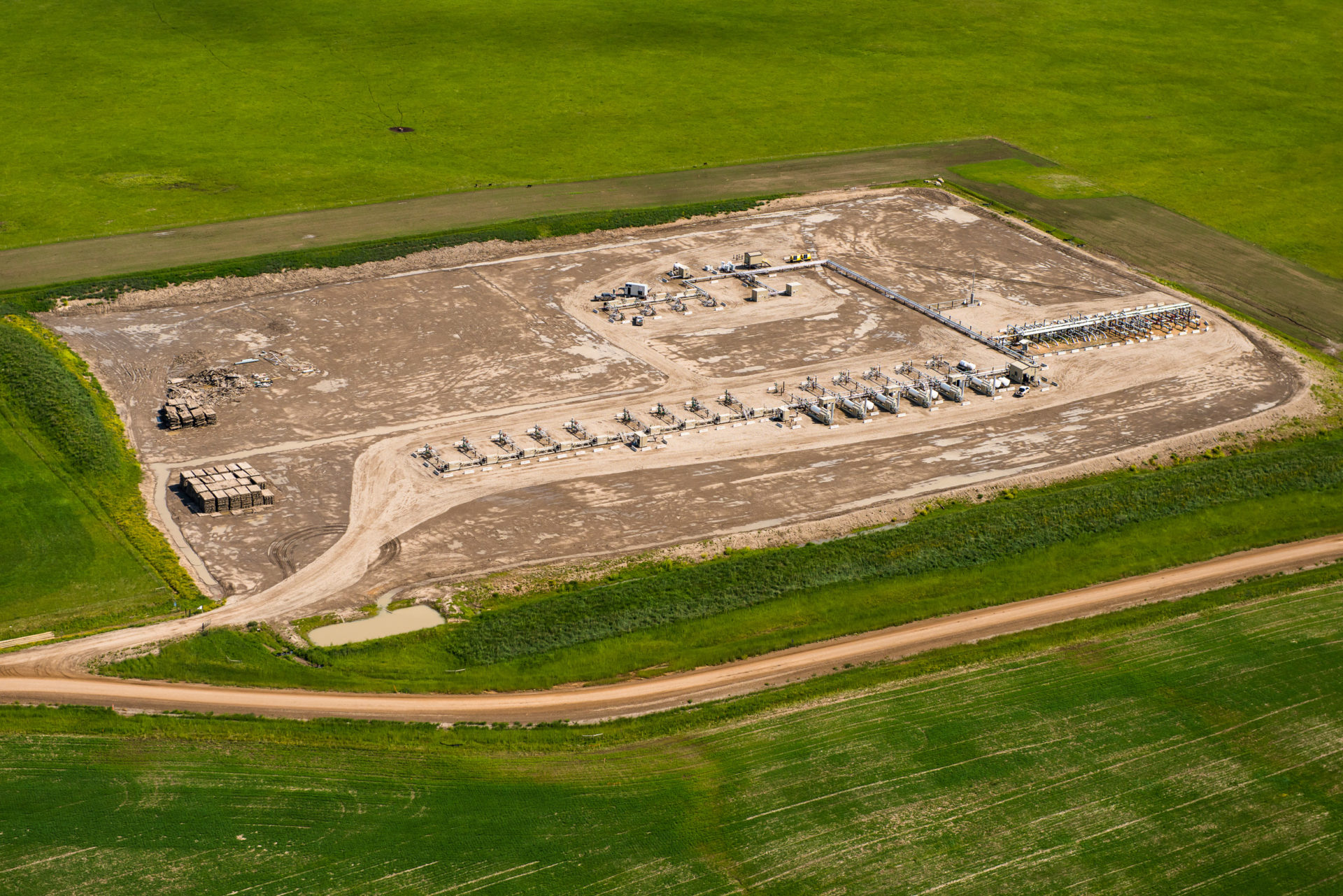
Oil and Gas development near Farmington, B.C. Photo: Garth Lenz / The Narwhal
In response, the government said Tuesday that it will need until the end of the year to come up with a “long-term action plan” in response to the panel’s recommendations.
Mungall’s ministry is responsible for both BC Hydro and the Oil and Gas Commission. When she struck the panel, she made no mention of BC Hydro’s long-standing desire to limit fracking operations in proximity to its dams and reservoirs.
Those concerns first surfaced three years ago after BC Hydro released documents in response to a Freedom of Information (FOI) request from the CCPA. The documents revealed that BC Hydro senior dam safety officials had serious reservations about fracking near its two existing Peace River dams and the Site C construction zone.
By far the largest dam in BC Hydro’s extensive portfolio is the W.A.C. Bennett dam. It impounds Williston Lake, the world’s seventh largest reservoir by water volume. Downstream of W.A.C Bennett dam is Peace Canyon dam, the second dam on the Peace River.
Peace Canyon dam is located in an area with known thrust faults, parts of the earth’s crust where two slabs of rock are pushed against one another under high pressure. During an earthquake, one slab can be forced up and over the other leading to violent earth shaking. BC Hydro dam safety officials know that two such faults begin downstream of Peace Canyon dam and run deep underneath the structure.
An email from Scott Gillis, BC Hydro’s dam safety engineer in the Peace River region, was part of the FOI materials and showed he was sufficiently alarmed by encroaching fracking operations that he warned senior staff at BC Hydro headquarters.
In a March 2013 email to Des Hartford, BC Hydro’s principal engineering scientist, Gillis noted that the subsurface at the Peace Canyon dam was similar to that around the Baldwin Hill dam near Los Angeles, which ruptured in 1963 damaging or destroying hundreds of homes and killing five people.
The Baldwin Hill disaster was later linked to oil and gas industry “fluid injection” operations and subsiding or sinking ground around the dam.
To avoid any such risks at Peace Canyon, Gillis proposed a solution to his BC Hydro colleagues: “Simply add buffer zones around any very Extreme and Very High Consequence Dams, where hydraulic fracturing cannot be undertaken without a prior investigation into the risks, and an implemented risk management plan.”
BC Hydro and the commission subsequently agreed that no new tenures or licences would be awarded to companies granting them further “subsurface rights” to drill and frack for oil and gas within five kilometres of Peace Canyon and W.A.C. Bennett dams or the Site C dam construction site.
BC Hydro and the commission also agreed that where natural gas companies already held such rights within five kilometres of the dams, greater caution would be taken.
“If future activity related to the existing tenures is planned, we will work closely with the Oil and Gas Commission to put restrictions in place to effectively manage risk,” Stephen Rigbey, BC Hydro’s then-director of dam safety, told the CCPA in 2016.
Rigbey said that at that time BC Hydro’s Peace River dams were built to high seismic standards and that the utility was not concerned that earthquakes triggered by fracking would bring the structures down or cause extensive damage. Rather, the utility was worried that the “carpet bombing” of increased gas drilling and fracking operations in proximity to the dams could lead to higher dam repair and maintenance costs.
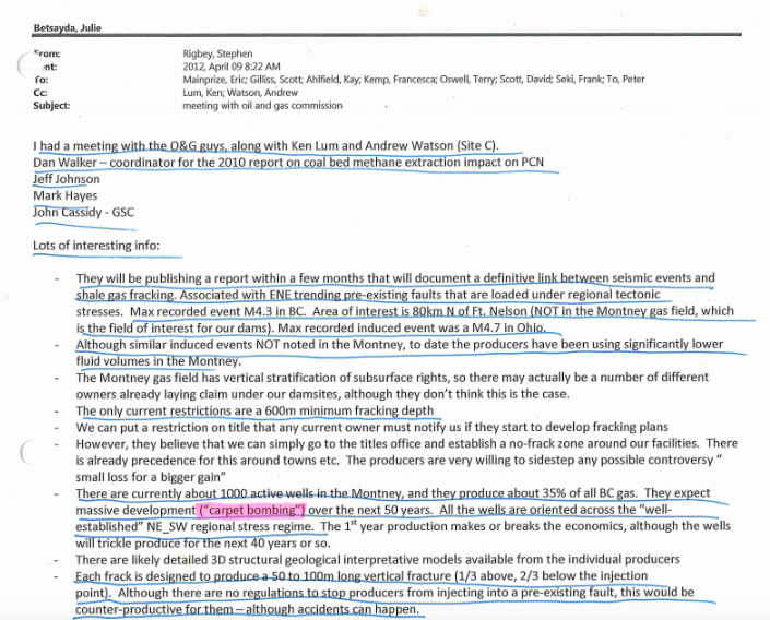
An internal email from Stephen Rigbey notes research on the links between fracking operations and seismic events. Rigbey writes the oil and gas industry expects a massive increase of active wells, a “carpet bombing,” in B.C.’s Montney region.
Despite the buffer zones, a number of oil and gas companies still have active subsurface rights nearby BC Hydro’s Peace River dams.
Mora Scott said one of those companies is Calgary-based Crew Energy, a company heavily invested in exploiting its Montney assets, particularly those zones rich in condensate.
Scott said Crew first contacted BC Hydro in January 2017 after the Oil and Gas Commission notified fracking companies of the new buffer zones.
“Since then, there have been a number of meetings between Crew Energy and BC Hydro. At these meetings, Crew Energy has updated BC Hydro on their proposed activities in the Site C area and provided summaries of observed seismicity during their well completion activities,” Scott said.
BC Hydro and Crew Energy officials met most recently at BC Hydro’s downtown Vancouver corporate headquarters on January 14.
Those meetings play out against a backdrop of marked increases in earthquakes in the vicinity of Site C.
Using an earthquake database maintained by Natural Resources Canada, the CCPA examined earthquake frequency over a 25-year period ending on December 31, 2018 nearby what is now the dam construction site.
Within 100 kilometres of the dam site there were 672 earthquakes in the past 25 years. Nearly 80 per cent of those events — 519 earthquakes in total — occurred in the past decade, a period that correlates with dramatic increases in gas drilling and fracking.
When the radius around the Site C site was narrowed to 50 kilometres, the total number of recorded earthquakes fell to 229. But the percentage of those events that occurred in the period’s last 10 years remained largely unchanged at 75 per cent or 171 earthquakes in total.
Of the 100 most powerful earthquakes to occur within 100 kilometres of the Site C location, 68 per cent — more than two in three — occurred in the most recent 10 years — a timeframe that again coincides with increases in drilling and fracking operations in the region.
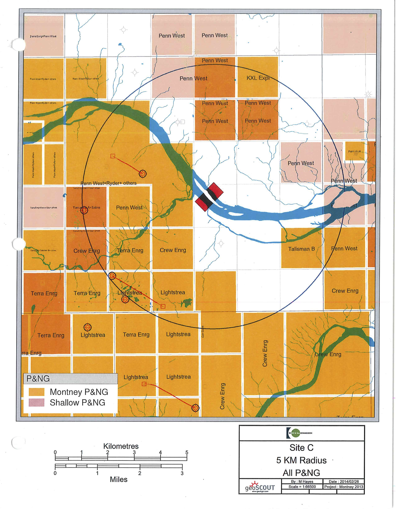
A map showing oil and gas leases within a five kilometre radius of the Site C dam. This B.C. Oil and Gas Commission map was obtained through Freedom of Information legislation.
Gail Atkinson, an expert on induced earthquakes and a professor in earth sciences at the University of Western Ontario, says that induced earthquakes behave differently than naturally occurring earthquakes in part because they may occur closer to the earth’s surface and generate different ground motions.
If at all possible, she said any induced magnitude four earthquake should be at least five kilometres away from critical infrastructure such as a dam.
“Larger magnitudes you want to keep even further away,” she added.
Asked whether she thought buffer zones might be warranted around other infrastructure such as hospitals and schools, Atkinson replied:
“An interesting question. That’s a matter for a broader public policy debate.”
She said it would be “sensible” for regulators to ask such questions and to decide what constituted “sensitive infrastructure.” Once that was done, she said, then decisions could be made about what to do.
Regarding the November 29 earthquake and the two aftershocks, Atkinson said it was “entirely reasonable” to cease CNRL’s fracking operations and that during the shutdown regulators should carefully consider “what happened and are there things they can do differently so that it doesn’t happen again.”

The way it’s raining over the Guilford Hereford ranch, you’d hardly know there’s a drought. “An April rain is invaluable to me, because that’s what...
Continue reading
British Columbia and the Haida Nation’s historic agreement recognizes Haida land ownership across the archipelago...

With years of political reporting experience, Shannon is poised to bring fresh stories to the...

Emails obtained by The Narwhal show city staff advising Industrial Plastics Canada on response to...

