
Ontario worried about ‘substantial’ costs to Enbridge Gas in deciding to overrule energy board: docs
When the Ontario Energy Board said Enbridge Gas and developers should pay for new fossil...

Every spring and typically in May the Kettle River hits peak flow.
A gauge placed in the water downstream of where the Kettle is joined by the Granby River has recorded those peaks for nearly ninety years, and in most years the peaks range between 20,000 and 30,000 cubic feet of water per second.
That’s enough water to fill an Olympic size swimming pool every four seconds, give or take. But for decades it has caused little concern in southern British Columbia’s Boundary region or the City of Grand Forks, which is located at the confluence of the two rivers.
In 2017, however, the Kettle’s peak flow hit 33,000 cubic feet per second, its highest point in 60 years.
Floods occurred.
Then last year all hell broke loose in “the quickest and fastest spectacle of nature” local resident Donovan Harris says he’s ever seen.
As the snowpacks melted, the small feeder creeks high up on the forested slopes behind the community swelled with water.
As the creeks merged with streams and later the Granby and Kettle rivers themselves, water levels rose frighteningly fast. By May, the swollen Kettle’s flow was a monstrous 48,500 cubic feet per second.
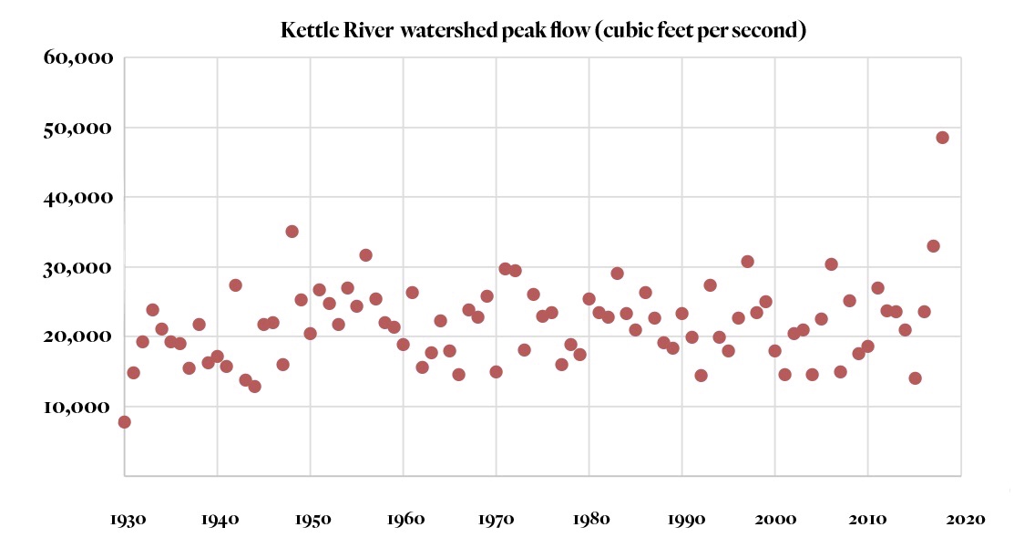
A graph tracking peak flow of the Kettle River since 1930 puts into historical perspective the incredible surge of floodwaters experienced in 2018. Data from the United States Geological Survey. Graph: Carol Linnitt / The Narwhal
For Jennifer Houghton, the difference between flood years was stark: a waterline on the walls of her home of 1.5 feet in 2017 and more than 4 feet the following year.
She now believes that the loss of her home and those of many of her neighbours had much to do with the relentless logging that has occurred in the region.

The highest point of floodwaters in Grand Forks, B.C. in the spring of 2018. Photo: Graham Watt
“Am I concerned that the flooding is going to get worse? Yes,” says Houghton. “Am I concerned that the logging is going to continue and make it worse? Yes.”
She adds, “I think our watershed needs a rest. And I think the government should seriously be considering putting a moratorium on logging in our watershed in high-risk areas until more assessment is done.”
Houghton is not alone in her concerns.
Widespread, disastrous flooding in the Fraser Valley was narrowly averted last spring when the Fraser River swelled. Many older forests in the valleys draining into the river’s upper reaches are gone due to clear-cut logging, raging wildfires and insect attacks, all of which can increase peak water flows.
Despite this, British Columbia’s Ministry of Forests, Lands, Natural Resource Operations and Rural Development continues to approve high logging rates while doing little to understand their cumulative effects.
This has prompted a former ministry employee and professional forester who served in numerous senior positions over a 40-year period to warn that further calamities may lie ahead.
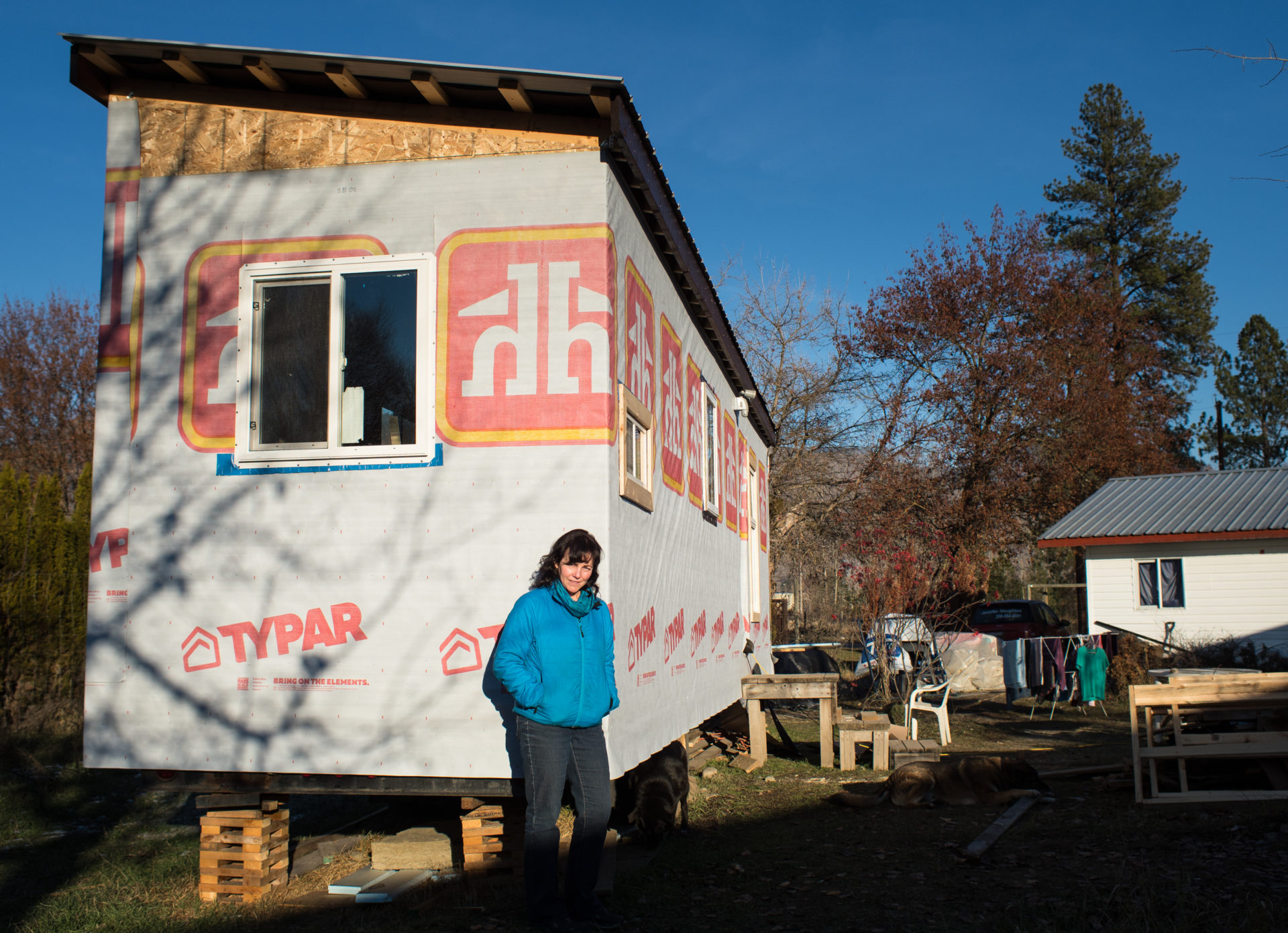
Jennifer Houghton stands outside her unfinished tiny home, November, 2018. Houghton, whose main home flooded twice in the last two years, was the first Grand Forks resident to apply to the city for a new tiny home permit. Houghton said she will move her tiny home should flood waters threaten her property in the future. Photo: Louis Bockner / The Narwhal
“The way in which the ministry operates is doing irreversible harm to the environment and to British Columbians,” says Anthony Britneff, who follows events in the Grand Forks area closely.
Since last fall, when The Narwhal visited the Grand Forks area to profile how local residents were faring in the aftermath of the flood, Houghton has spearheaded efforts to raise awareness about how accelerating forest losses may have contributed to the calamity — a delicate task in a community with a longstanding forest industry presence.
Her efforts culminated in a public meeting in January at which ecologist and professional forester, Herb Hammond, and local woodlot owner, Fred Marshall, spoke.
Grand Forks residents prep for winter in sheds, RVs after catastrophic flooding
At the meeting, Hammond used maps prepared by Dave Leversee to highlight his concerns.
The Seattle-based mapping expert has documented declines in old-growth forests on Haida Gwaii, Vancouver Island and portions of B.C.’s vast interior.
Leversee’s maps graphically captured the logging in valleys draining into the Kettle and Granby rivers, especially the spider’s web of clear-cuts higher up on the slopes where the air is colder and deeper snowpacks naturally occur.

Mapping showing the location of clearcut logging in high elevation areas in the Kettle River watershed. Map: David Leversee
Hammond likened the proliferation of clear-cuts to “a bad case of the measles” and said they have altered the natural movement of water through the landscape.
In clear-cuts, all the trees in a forest are cut down. The logged lands accumulate up to 40 per cent more snow than in an unlogged forest, Hammond said. When temperatures warm, the melting snow and runoff from the clear-cuts occurs far faster than in the forest.
“All of that adds up to degraded hydrology and things like floods and the droughts that will come next,” Hammond warns.
Trees in a healthy forest, transpire somewhere between 500 and 700 millimeters of water per year, says Allan Chapman, a hydrologist and professional geoscientist who retired in 2017 after a 30-year public service career including stints with the forests and environment ministries and the Oil and Gas Commission. That’s water that is taken up from the tree roots and released back into the atmosphere — water that does not accumulate in the soil to later enter streams and rivers.
In the absence of trees, “soils become wetter,” Chapman says. “Why is that important? Because when you log an area, the ability of soil to store water is reduced, therefore more of that water runs off quicker.”
Trees in unlogged forests also capture one quarter or more of falling snow. Through a process called sublimation, much of that intercepted snow returns to the atmosphere as a gas, skipping the liquid phase all together. In clear-cuts there is nothing to intercept that snow. It just builds and builds.
While logging companies must “reforest” what they clear-cut — something typically achieved by hiring tree-planting crews to do the brutal work of sinking new seedlings into the scarred earth — it will take 30 years or so following planting before the new trees transpire healthy volumes of water once again, Chapman says.
Assuming, that is, that the young trees survive. Increasingly, many of them do not — they’re dying prematurely in wildfires and from pest and disease outbreaks.
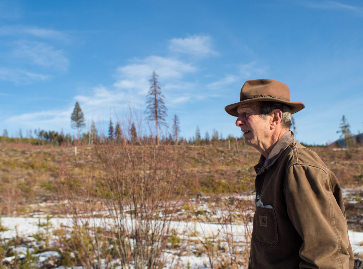
Retired forester, Fred Marshall, walks through cutblock 04Q-09, a 454-hectare clearcut logged by Interfor above the Boundary Creek drainage. Marshall believes questionable logging practices are one of the main causes of the Grand Forks floods. Photo: Louis Bockner / The Narwhal
In Baker Creek, a watershed near Quesnel, 90 per cent of the trees are either killed by mountain pine beetles or clear-cut. The result, Chapman says, is “larger volumes of runoff in Baker Creek that will persist for decades.”
Bob Simpson, a former MLA and forestry critic, is Quesnel’s mayor. The city boasts the biggest forest industry investments per capita of any community in B.C. and has two pulp mills, sawmills, panel mills and value-added mills.
Quesnel is also at the epicenter of the most dramatic changes to forests in the province, particularly on the sprawling Chilcotin plateau west of the Fraser River.
“It’s a blown-out landscape. It’s either dead from mountain pine beetle, or other pests and diseases, or burnt,” Simpson says, adding that the critical test for his community, the forest industry and the province is to make that landscape more “resilient.”
In 2017 and 2018, out-of-control wildfires burned more than 2.4 million hectares of forest in B.C., roughly four Prince Edward Islands. Many of those infernos, which cost $700 million to fight, were near Quesnel and in the greater Fraser River watershed.
During last year’s record wildfires, Premier John Horgan called the devastation “the new normal” of climate change. But Simpson says such comments are unhelpful and divert attention away from essential questions about how B.C.’s forests are managed.
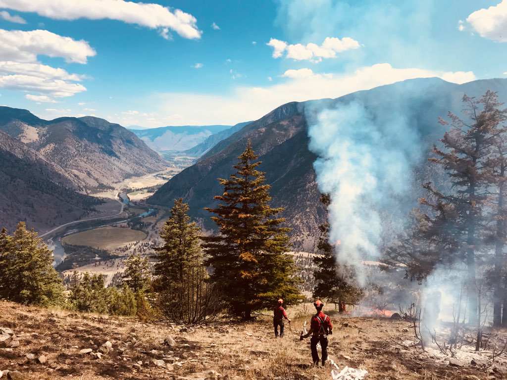
Wildfire control near Clearwater B.C. in the Chilcotin region, July 2018. Photo: B.C. Wildfire Service
For example, logging companies typically plant more lodgepole pine trees than they log. Why? Because pine trees thrive in open, sunny settings — precisely what you get when you clear-cut a forest. Such planting then sets the table for the beetles that are building in number due to climate change. Many of those trees then burn in wildfires, which forest scientists have predicted for decades will increase in frequency and severity as temperatures warm and drier conditions prevail.
Our forests are “just not managed in a way that is resilient to endemic pests and diseases and is resilient to wildfires that are part of the natural cycle,” Simpson says. “We have a simplified landscape that cannot, does not, have the natural breaks, does not have the natural stopgaps to stop these massive epidemics that we’re experiencing and then these massive fires.”
Burned forests then exacerbate problems, potentially increasing flood severity.
“For some period of time after a hot fire occurs, the upper levels of soil have a waxy layer that is hydrophobic and a decreased volume of water enters the soil. It just runs off,” Chapman says. That increased runoff may last for years.
In a presentation to Grand Forks city council in early January, Jeff Becker, forests and woods manager for Interfor, one of the largest lumber producers in the world, noted how wildfires are increasing in severity in the Grand Forks area where the company operates a sawmill.
Wildfires burned more than 24,000 hectares of local forest in the last four years — more than twice the area burned in the 30 years before that.
During his presentation, Becker said he knew about the meeting that Houghton was organizing for the following week. He wanted to make sure that council members had certain “facts” before them prior to that meeting.
“There’s been a bit of misinformation on exactly what happened and how it happened,” Becker said. “We just want to make sure that there’s a balanced kind of view on it.”
Becker said the key reason for the flood was “unusual” weather including a snowpack that was 230 per cent above normal, warm spring weather and rains that accelerated the snow melt.
“We know that happened,” Becker said.
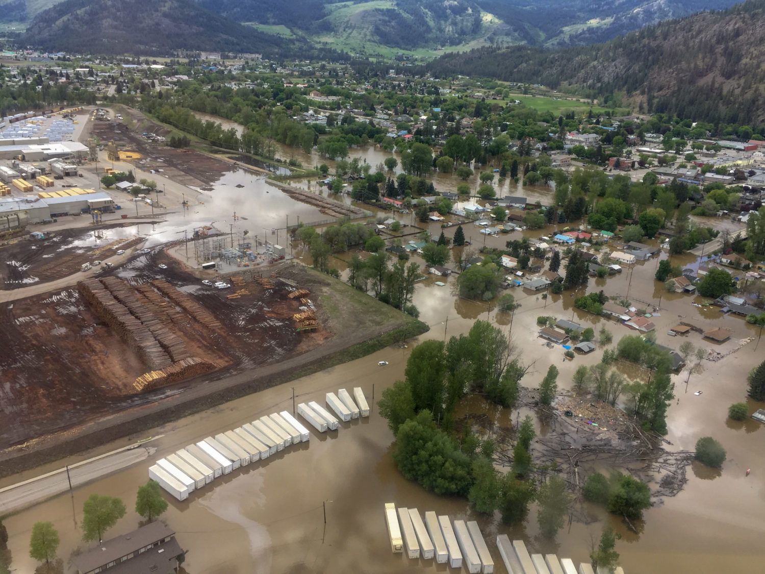
An aerial view of Grand Forks flooding, courtesy of Sergeant Mike Wicentowich, one of many RCMP officers dispatched in response to the significant 2018 spring flood. Interfor’s property can be seen centre left. Photo: Sergeant Mike Wicentowich
While Becker did not deny that “forestry isn’t part of the issue” when it comes to altered water flows, he claimed that roughly only one per cent of forests in the Grand Forks area were logged each year.
Becker’s remarks clearly resonated with Grand Forks councillor Chris Moslin who singled out Becker’s employer for praise. “This town relies on Interfor, not just for employment but…for flood protection,” Moslin said, adding that the company had donated heavy equipment and personnel to battle the rising waters.
Eight days after Becker’s presentation, people attending the meeting organized by Houghton heard a different story. They learned that 18 per cent of the total land base in the valleys draining toward the Granby and Kettle rivers had been logged since 1990, an amount not far removed from what Becker said.
But they also learned something else. That the vast amount of that logging was concentrated at higher elevations where more snow accumulated. In fact, 44 per cent of the “harvestable” timber — industry jargon for available to log — had been clear-cut in such forests.
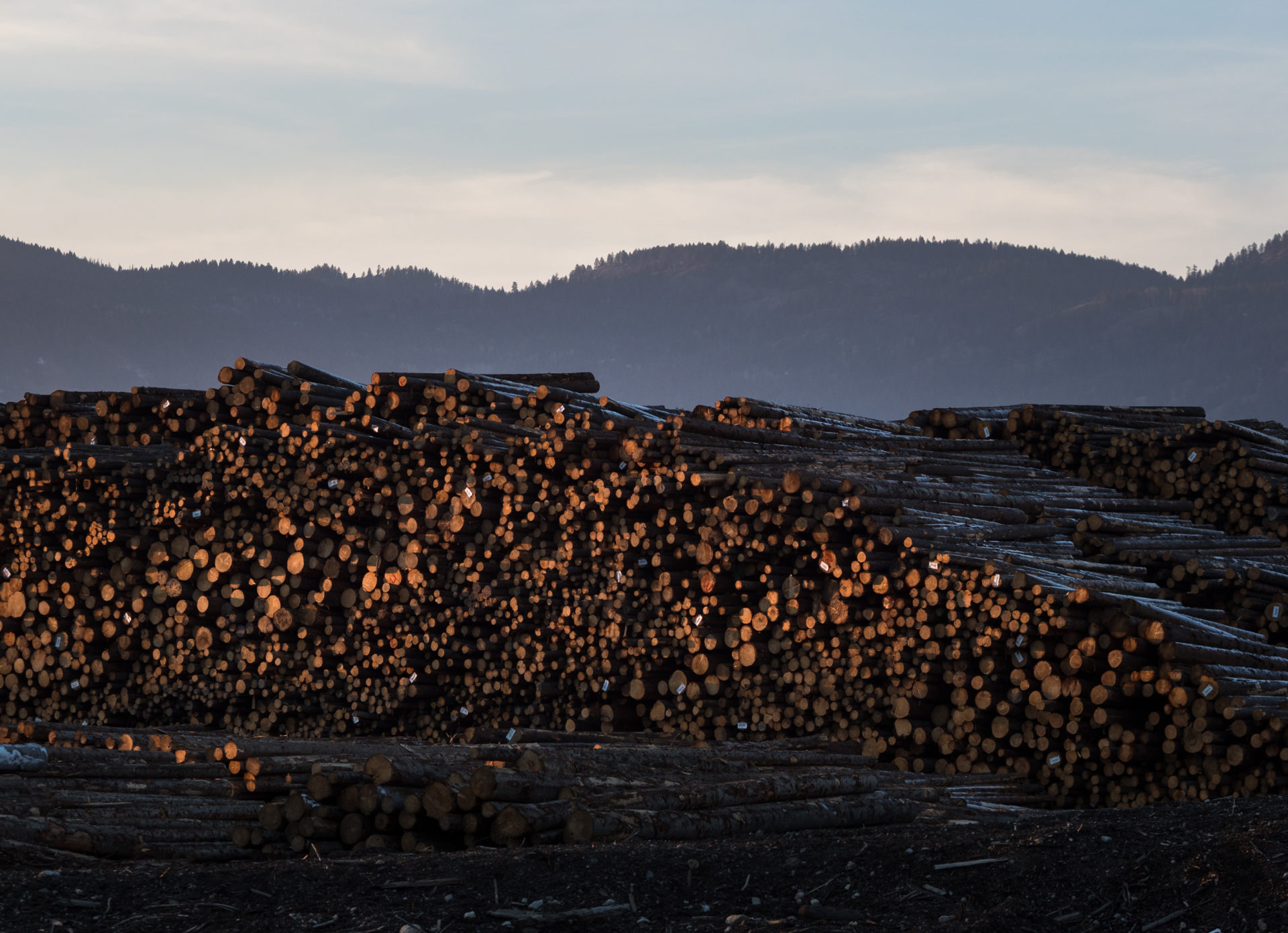
Interfor’s lumberyard across the Kettle River from downtown Grand Forks. Some residents believe that dykes built to protect the forestry giant’s property made flooding worse for neighbouring communities because the water had nowhere else to go. Photo: Louis Bockner
And they learned of a sprawling network of roads in the watersheds that outside of the clear-cuts themselves totalled 13,000 kilometres, the equivalent of driving a car from Victoria to St. John’s Newfoundland and then back across the country again as far as Winnipeg. The ditches alongside those roads filled with snowmelt during the spring, channeling water toward Grand Forks just as surely as the watershed’s creeks and streams did.
The cumulative effect of all that disturbance was the loss of older forests on fully one quarter of the land base. An undetermined amount more forest was also lost to insect attacks and disease outbreaks.
Chapman says that once the total area of older forest lost to disturbances reaches about 30 per cent, there will be “measurable” signs of that in water flows.
If the forests in and around Grand Forks are not yet at that tipping point, they are perilously close to it.
Shortly after Gordon Campbell led the BC Liberals to their first of four successive electoral victories in 2001, a new era of deregulation was ushered in. The government scrapped B.C.’s highly prescriptive Forest Practices Code, which spelled out in detail what logging companies must do, and replaced it with the Forest and Range Practices Act. The new regime was grounded in a philosophy that government should not tell companies precisely what to do but set broad objectives instead and let professionals working for the companies decide how to meet them.
The era of “professional reliance” was born.
Prior to that, Chapman said, foresters were required to do hydrological assessments and “cumulative impacts assessments” in community watersheds and watersheds with higher fisheries values. Those requirements are now largely gone.
The result, Chapman said, is that “there’s probably nothing going on in B.C. that highlights the cumulative effects on hydrology of land-use activities.” This at a time when climate scientists predict more droughts and more floods.
Britneff says he is very concerned about the size of some clear-cuts in the Grand Forks region and their impacts on water flows. The long-time civil servant and professional forester notes that some logged areas above Grand Forks are up to 11 times larger than what the province’s chief forester recommends. Ironically, many of those larger clear-cuts were approved by BC Timber Sales, a Crown agency that promotes the “safe, sustainable development and auction” of publicly owned forests.
Fred Marshall shares Britneff’s concerns. He says BC Timber Sales’ current plans call for more than half of all new clear-cuts to be 40 hectares or more in size. Yet BC Timber Sales is only supposed to allow such clear-cuts if there is a compelling “forest health” reason to do so.
In an emailed response to questions from The Narwhal, Britneff said that a moratorium on logging higher elevation forests in the Grand Forks region is warranted and should remain in effect “until the Ministry has obtained independent, third-party assessments for the Kettle watershed for cumulative effects.”
Britneff added that the ministry’s cumulative effects analysis must include an assessment of how logging and other forest losses may impact peak water flows and increase flood risks.
While a moratorium does not appear imminent, Houghton’s efforts and those of others in the community have been noticed. Cumulative effects finally appears to be on the government’s radar.
Cassidy van Rensen, an ecosystems biologist with the ministry of forests’ regional offices in Kootenay-Boundary, confirms that the ministry is now committed to doing a cumulative effects analysis of the Kettle and Granby watersheds. The analysis “will involve a number of different policy-makers, experts, industry and public at different stages,” van Rensen said.
In a conversation with The Narwhal, van Rensen said that the analysis, which could result in recommendations as early as this summer, came at the request of BC Timber Sales. The Crown timber auctioneer is ultimately responsible for approximately 40 per cent of all the logging in the timber supply area or TSA outside Grand Forks.
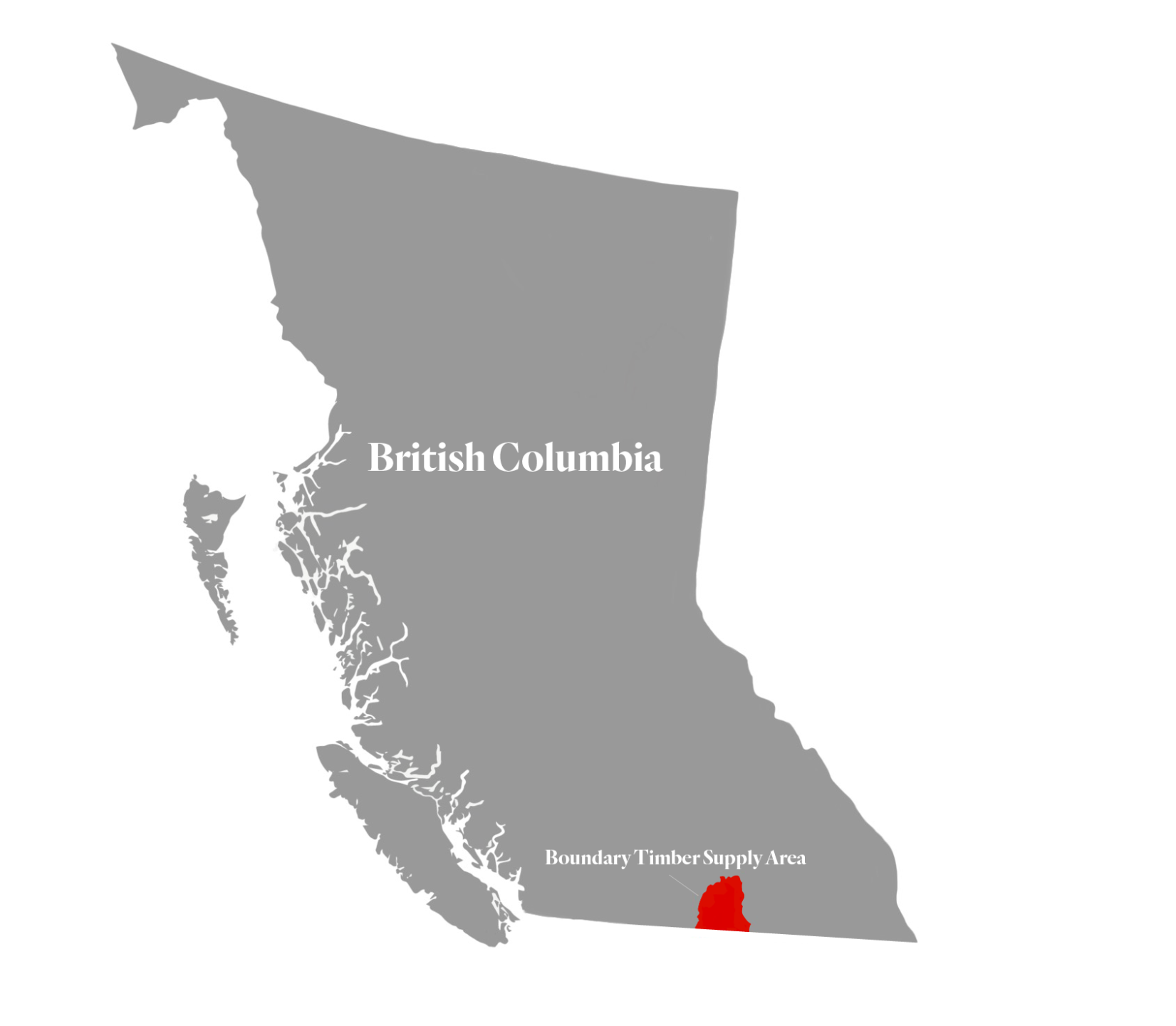
Location of the Kootenay Boundary Region’s Timber Supply Area. Graphic: Carol Linnitt / The Narwhal
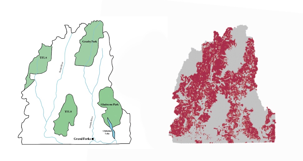
Left: The Kootenay Boundary Region Timber Supply Area surrounding Grand Forks, B.C. The TFL 8 or Tree Farm Licence 8 areas are regions where exclusive timber harvesting rights are held by companies. Right: the “timber harvesting land base” as identified by the province of B.C. Graphic: Carol Linnitt / The Narwhal
Marshall says he believes the devastation unleashed by last spring’s floods “stimulated” the government to act. He hopes that van Rensen and others will “heavily focus on the clear-cuts at higher elevations” as they do their work.
Meanwhile, residents of Grand Forks continue to grapple with harsh realities nine months after the flood.
Donovan Harris, his wife Dayna, their 10-year-old son Julien and infant son Harlon lost pretty much everything in the flood, which destroyed their double-wide mobile home and adjacent log cabin.
There was still $70,000 outstanding on the mortgage when the waters came. Their house insurance did not cover flood damage claims. The couple eventually purchased a house on higher ground for $215,000.
The new mortgage payments are an additional $1050 a month.
“It’s straight up paycheque-to-paycheque now,” says Harris, who works as a kitchen manager at Silver Kettle Village, a retirement home. “If I get sick one day we’re not paying the bills.”
In late January, the City of Grand Forks through its Boundary Flood Recovery Team applied to the federal government’s Disaster Mitigation and Adaptation Fund for nearly $50 million in funds to protect local homes and businesses from future floods.
“The local Boundary flood team is working really hard to get money for berms, buyouts and changing infrastructure. But that’s not going to happen in time for this year,” Houghton says.
Until the money comes and until the work is done, Houghton says the provincial government and BC Timber Sales in particular need to look at the “social and economic wellbeing” not just of the logging industry, but the communities downstream. And they need to do so quickly.
“Every single day I wake up and I see my destroyed home. Every day I see the walls that were wrecked,” Houghton says. “I don’t think people realize the danger we’re in. I don’t think they understand the gravity of the situation we’re in.”
Update March 14, 2018 8:26am pst. This article previously stated the BC Liberals won the first of four successive victories in the year 1991. The year was in fact, 2001. An update has been made to reflect this fact.

Ontario’s garbage is making headlines again as a small farming town tries to ward off a large construction company’s efforts to revive and expand a...
Continue reading
When the Ontario Energy Board said Enbridge Gas and developers should pay for new fossil...

Investigations, photojournalism and other reporting from 2023 are being recognized by the Canadian Association of...

The air is biting cold as Willie Bertacco navigates his motorboat through the blackness that...

