


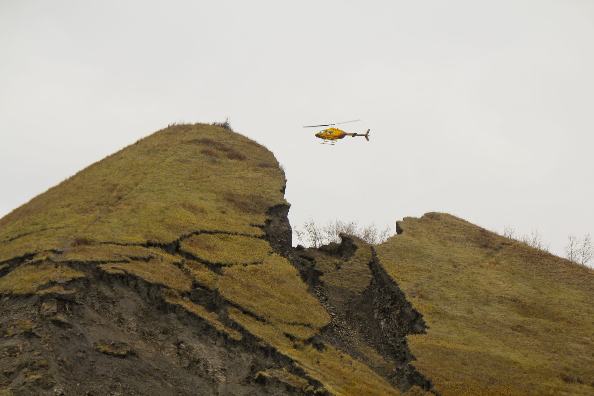
The landslide began on the last day of September, a day no resident of the small Peace River community of Old Fort will forget.
A slide on a steep slope near the town quickly buckled and destroyed portions of the only road leading into and out of the community. Before long, the road was buried under a mass of earth, rock and trees, and the seemingly unstoppable wall of slumped and moving earth forced the evacuation of the community’s 200 residents.
Ever since then, residents have had lots of questions of B.C.’s Ministry of Energy, Mines and Petroleum Resources. Questions about whether the slide may have been triggered by a gravel mining operation at the top of the slope.
They continue to wait for answers from a ministry that also has ultimate authority for major hydroelectric dams, oil and gas industry operations and mines, all of which have the potential to trigger landslides, especially if they occur along the river that borders their community.
During the community’s evacuation, information was released about a historic “failure” at the very same location, directly downslope from a gravel mine. Locals now wonder aloud why the operation was permitted given foreknowledge of slope instability.
“Is this a natural occurrence or is there a man-made reason behind this?” asks Old Fort resident Kali Chmelyk.
“I want to know that those hills are not going to come crashing into our community.”
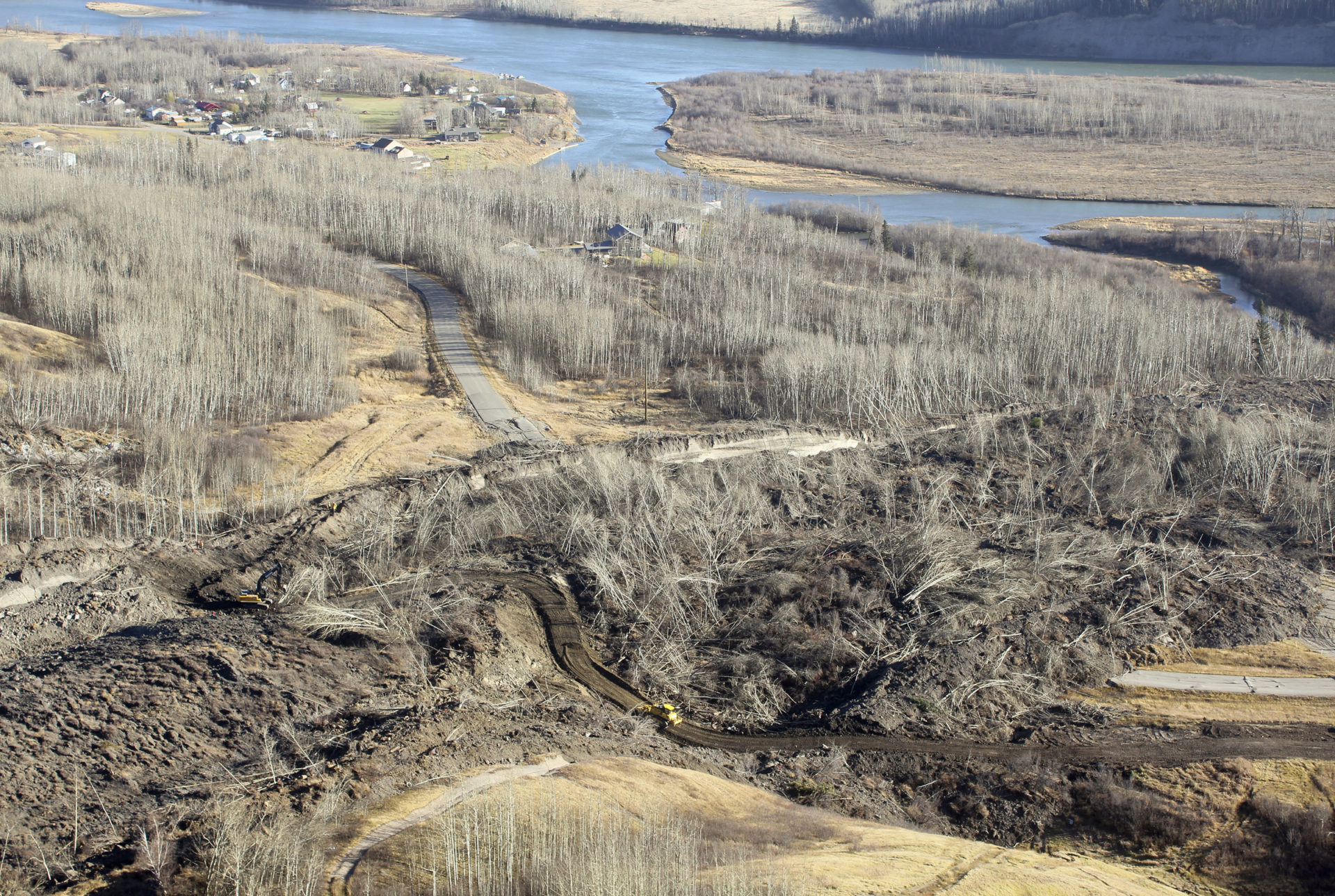
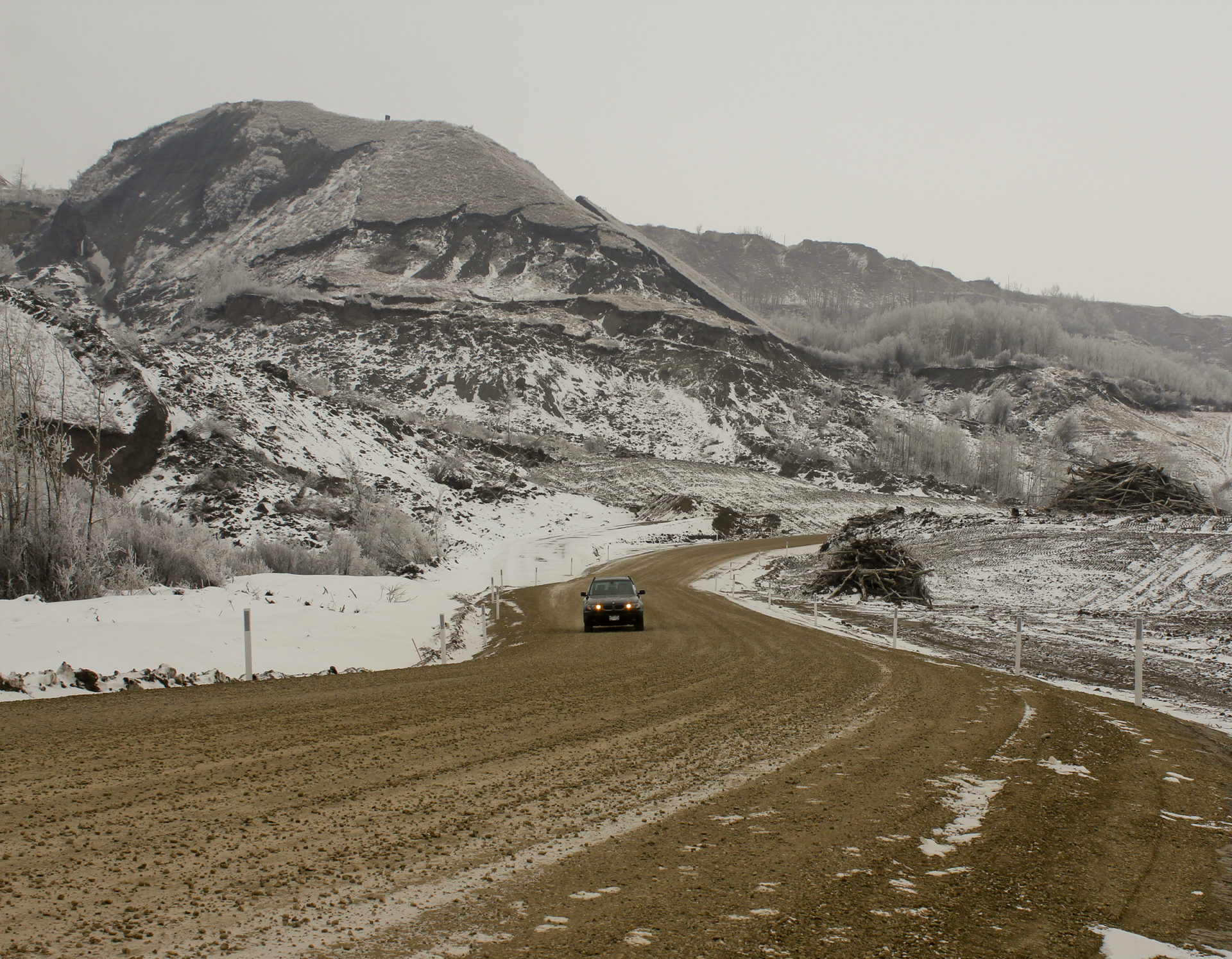
Work is done on a temporary access road, October 20, 2018. Photo: Matt Preprost / Alaska Highway News
‘We cannot release any information’
The steep slopes siding the Peace River are notoriously unstable.
Over the years dramatic landslides have blocked the river, wiped out bridges, and sent plumes of sediment coursing down tributaries and into the main stem of the river for months on end.
Which now begs the question why B.C.’s ministry of energy would knowingly allow a new gravel mine to operate on the very same parcel of land where a previous mining venture had caused slope failures.
Sometime after the September slide occurred and a local state of emergency was declared, the ministry of energy launched an investigation into events at the slide site.
But the ministry is refusing to release any documents or correspondence with the mining company about known “slope stability” concerns — because, they say, an investigation is currently underway.
As Old Fort’s 54 homes were being evacuated in early October, images of the slide began appearing, showing huge stockpiles of mined gravel very close to where the slide began.
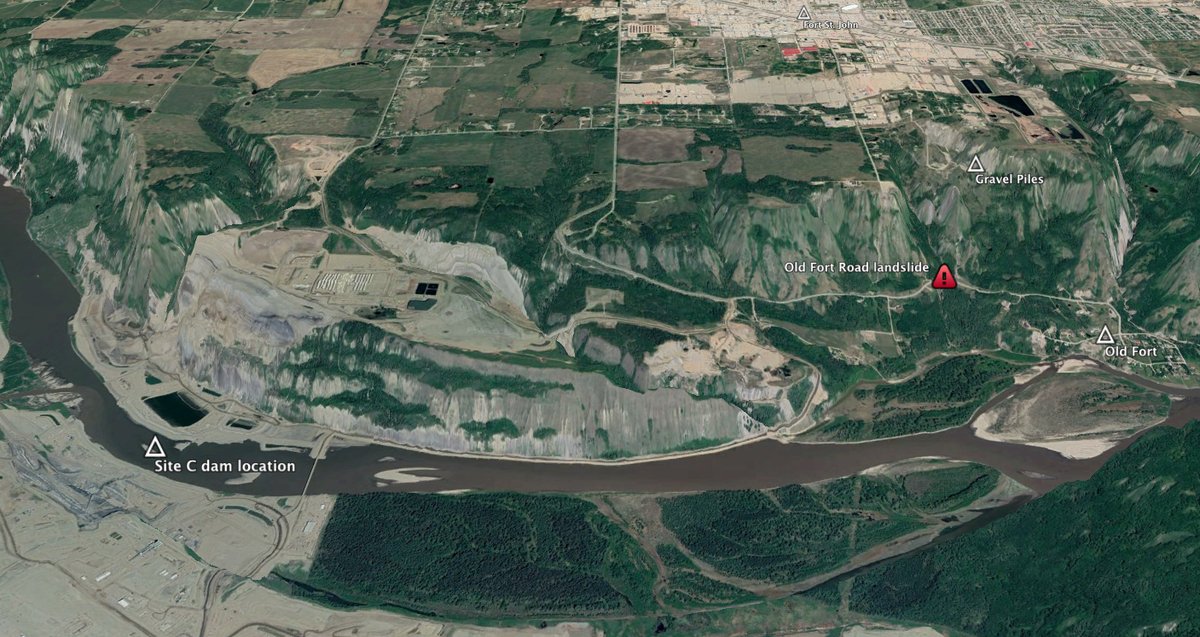
Google map showing the location of the Old Fort landslide in relation to the gravel pits and the Site C dam. Photo: Cathrine Ruddell / Twitter
In response to a request for any documents relating to unstable slopes at or near the mine site, the ministry’s communications director, David Haslam, responded by e-mail in early November, furnishing only copies of the original “Notice of Work” filed in May by mining company, Deasan Holdings Ltd., and the “Sand and Gravel Permit” issued to the company by the ministry on August 7.
All other documents, including correspondence between the ministry and the company regarding unstable slopes were withheld.
Pasted to the bottom of Haslam’s e-mail was an undated note from Al Hoffman, chief inspector of mines, indicating that he had ordered an investigation into the Old Fort slide under Section 7 of the Mines Act.
“We cannot release any information that might prejudice an active investigation,” Hoffman said, adding: “All other documentation is now part of the ongoing investigation and may not be released publicly at this time.”
Section 7 of the Act grants powers to the chief mines inspector to order an investigation into any “accident” that may have caused “personal injury, loss of life or property or environmental damage.”
Slopes historically unstable
The community of Old Fort lies close to the river only a short distance downstream from the Site C dam construction site where “tension cracks” appeared on the unstable north riverbank in February and again in May, 2017. Those cracks forced a BC Hydro contractor to remove massive quantities of earth to reduce the risk of a slope failure in the vicinity of the project, the costs of which have ballooned from $6.6 billion to an estimated $10.7 billion.
At a lengthy public meeting organized by the Peace River Regional District the day after the evacuation, a ministry spokesperson fielded numerous questions from residents about the gravel mine, including one from evacuee Gordon Pardy.
“If a little bit of common sense could take place here you might ask the question: Why would a very large heavy pile of crushed material be stockpiled right on the edge of an unstable — a historically unstable — valley?”
“Those are the things that we will be looking into with our investigation,” replied Adrian Pooley, who works in mines operations at the ministry’s offices in Prince George and who joined the meeting remotely by speakerphone.
During the meeting, Pooley revealed that there had been a previous “failure” at the mine site sometime in the 1980s or 1990s when another company had operated there.
A portion of a slope on the northeast side of the property collapsed after gravel was excavated from below. “There were some studies that went into that and some conditions around no further removal of material up in that portion [of the property],” Pooley said.
The Old Fort slide occurred at the south end of the property, away from where gravel was being actively removed but near where large piles of gravel had been stored, Pooley said. On the day that the slide occurred, the ministry of energy and mines received reports that the outer edge of the gravel quarry or excavation area had dropped eight to 10 metres.
Both the area of the property that was actively mined and the land where the company was temporarily storing gravel before delivering it to customers, are under the ministry of energy and mine’s jurisdiction.
Pooley went on to say that the mining company “did not do a study on the weight of the stockpiles” and added more generally that no geotechnical studies had been done “on the slope on the south end of the property.”
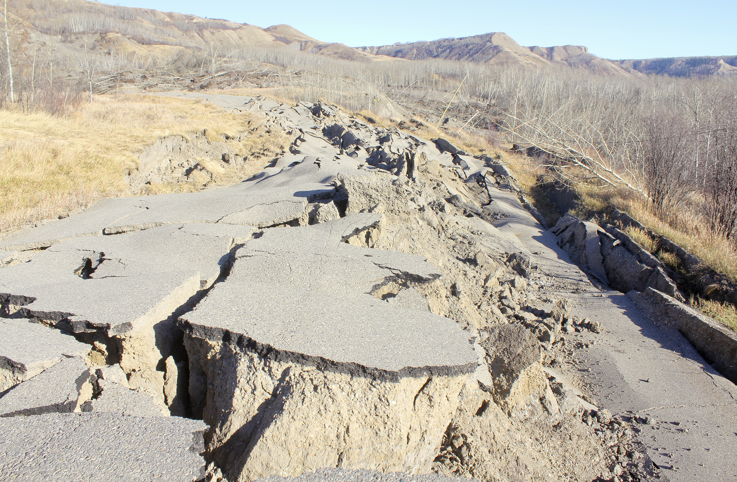
A section of Old Fort Road, heavily damaged in the landslide. Photo: Matt Preprost / Alaska Highway News
Officials warned of ‘slope stability issues’
Pooley’s comments generated numerous questions and responses from Old Fort residents attending the meeting, including from one who felt that it was a “conflict of interest” for the ministry that issued the mining permit to conduct an investigation into what may have gone wrong at the mine site; another who questioned who would be held liable should the mine be linked in some way to the slide; and another who maintained that local residents had witnessed a smaller slide at the mine site months before the bigger slide but that nothing had been done.
As previously reported by The Narwhal, information filed with the Peace River Regional District by the former mine owner shows that a little more than three years before Deasan Holdings commenced gravel extraction this summer, an official warned of challenges at the site.
That warning came from Kris Bailey, the ministry’s inspector of mines permitting in Prince George.
“Please be advised that based on the past geotechnical and slope stability issues present both at the site and surrounding areas a mine plan will be required to be developed by a qualified geotechnical and or mining engineer. It is strongly advised that any potential future mining proponents contact this office prior to mine planning,” Bailey wrote then mine owner Jack Blair, on July 17, 2015.
Bailey, who still works for the ministry but in a different capacity, said during a phone conversation following the slide that he could not provide copies of the mine plan or any related documents because the matter had been pushed “up the food chain” in the ministry. He referred questions to Diane Howe, deputy chief inspector of mines permitting.
Howe did not return phone calls.
‘Extreme caution…should be observed’
Arthur Hadland, a longtime resident in the Peace Region and a former director of the Peace River Regional District, says nobody should be surprised by the slide.
“The banks of the Peace River have been identified as extremely unstable ever since man started messing around with it,” Hadland said, adding that that reality is well understood in the ministry.
Hadland noted that in 1991, then energy and mines minister, Jack Weisgerber, had received a report from Norm Catto, with the Geological Survey Branch. Catto’s report noted that some of the most accessible gravel deposits in the Peace River region were along the river itself, an area that was known for being extremely unstable.
“Slope failure is ubiquitous along all of the major streams in the region,” Catto wrote in his report, adding later: “Extreme caution should therefore be observed in any effort to exploit or utilize river valley slopes.”
Given the known risks, Hadland said it is imperative that any investigation into the Old Fort slide has as its priority “the safety of downstream people.”
That investigation should be broad, he said, and include all land-use activities that could conceivably destabilize slopes including gravel mining operations, oil and gas industry gas wells and disposal wells, the Site C dam, and two large Fort St. John sewage lagoons nearby to Old Fort.
Documents give insight into pre-existing concerns
Despite the ministry’s decision to withhold key documents, enough information exists in the mining permit issued to Deasan Holdings to indicate that the office had concerns about the region’s unstable slopes.
The permit was signed by Victor Koyannagi, a professional engineer and senior inspector of mines, and is dated August 7 of this year. The seven-page document is peppered with references to geotechnical concerns, including “slope stability,” “erosion,” and “unstable slopes.”
At one point, the permit notes:
“…a qualified professional engineer shall determine the potential inundation zone (Zone) for all unstable slopes including the eastern pit slope that has already slumped. This zone shall be clearly illustrated on a map and shall be provided to the Regional Inspector of Mines prior to initiating mining activities. The Zone shall be clearly defined and marked on the ground ensuring equipment and workers are prohibited from entering the Zone.”
The document also clearly instructs Deasan to hire a “qualified professional engineer” to design any “temporary and permanent stockpiles” of gravel. And that “daily visual inspections” of such stockpiles are required “to ensure stability and erosion control is maintained.”
At least two documents that may have been withheld from the public by the ministry are referred to or alluded to in the permit.
The first is a “slope design” document prepared for Deasan Holdings by Tryon Land Surveying Ltd., a company that has operated in northeast B.C. since 1961. On its website, Tryon says that it specializes “in the design and execution of civil and land development engineering as well as structural engineering,” including mining projects.
The permit also notes that Deasan was required to file a “geotechnical incident report” in the event of any “dangerous occurrence” at the mine site.
One such occurrence appears to have happened during the summer.
Bob Banack, a resident who lives just west of the gravel mine site said that sometime in late July or early August he witnessed a slide at the site. The slide was triggered as a road was being built down toward where the gravel piles were eventually placed, Banack said.
“When they did build that road…it rained. And that whole hill, basically, it slid all the way down,” Banack said. “There were a couple of guys at the bottom and a couple of guys at the top and the guys at the bottom were standing with their hands out.”
Banack said he phoned the City of Fort St. John to alert officials to what he saw, but was told that the property was not under municipal jurisdiction. Banack added that he “assumed” the gravel pit operator had reported the incident.
Following the public meeting where Pooley fielded questions, Banack said he received a call from Pooley asking him to explain what he had witnessed at the site.
Residents, still on evacuation alert, say scope of investigation unclear
Peace River Regional District board chair Brad Sperling said most residents in Old Fort are now back in their homes.
One property and house was damaged by the slide and is now uninhabitable, another half dozen homeowners closest to the leading edge of the slide have been told to remain on evacuation alert because their properties could still be threatened, Sperling said.
A new road to Old Fort was constructed on top of the landslide. The speed limit posted along the new roadway is 30 kilometres per hour. Photo: Matt Preprost / Alaska Highway News
As of now, Sperling says the Peace River Regional District has received no formal notice from the provincial government about which ministries may ultimately investigate the slide and its causes.
While he said he knew that the ministry of energy and mines was investigating the events at the mine site itself, he felt that such an investigation needed to be expanded.
“We want the answer from the province, not a single ministry,” Sperling said.
Public Health and Safety Minister, Mike Farnworth, flew over the slide on October 10.
During the course of his visit, the slide advanced 20 metres, about five times more than it had on average since the slide had begun 11 days earlier when the district declared a local state of emergency.
“Once this whole issue has been resolved, once the slide is stabilized, once people know what the long-term situation is going to be, of course there’s going to be an investigation into how this happened, why it happened, and are there measures that need to be taken to mitigate or ensure it doesn’t happen again,” Farnworth told the Alaska Highway News, which has reported extensively on the slide since it began.
One month after Farnworth’s visit, however, the scope of any promised investigation remains unclear. His ministry even declined to answer questions about whether it would participate in such an investigation, referring all questions to the ministry of energy and mines.
After e-mailing questions to Farnworth’s ministry about what provincial ministries would take part in any investigation, Jordan Turner, a communications manager covering Emergency Preparedness, part of Farnworth’s ministry, phoned to say that answers would come from someone else.
“That response will come from energy and mines,” Turner said.
The ministry of energy and mines subsequently confirmed that it is currently the only provincial ministry actively investigating the slide.