


By Tim Burkhart, former researcher with the Cohen Commission and Peace River Break Coordinator with the Yellowstone to Yukon Conservation Initiative.
On a clear day after the thaw, I climb a meandering hiking trail through thick forest, crossing springs swollen with alpine melt, and scramble up rocky slopes to a wind-swept vista of alpine tundra at the weather-beaten peak of Mount Bickford, about 40 minutes west of the small industry town of Chetwynd, B.C.
From this lofty vantage point above the Pine Pass, the crucial east-west length of Highway 97 is visible, connecting northeast B.C. with the rest of the province west of the Rockies.
Standing beside the dark waters of a mountain lake, still fringed with snow, I can gaze out upon an uninterrupted view of one of the most important landscapes in British Columbia.
This is the Peace River Break, the lifeblood of a diverse ecosystem and a critical part of a continental landscape. The east-west traveling Peace River is the only major river to “break” through the Rockies, funnelling warm Pacific air across the mountains.
This unique geography creates a continental climate that supports diverse ecosystems, acts as a sanctuary to a number of threatened and endangered species, and provides rich soils that could feed up to a million people.
The Peace River Break landscape is an integral and critical part of a continental puzzle, whose pieces make up the Yellowstone to Yukon corridor, one of the last intact mountain ecosystems on Earth.

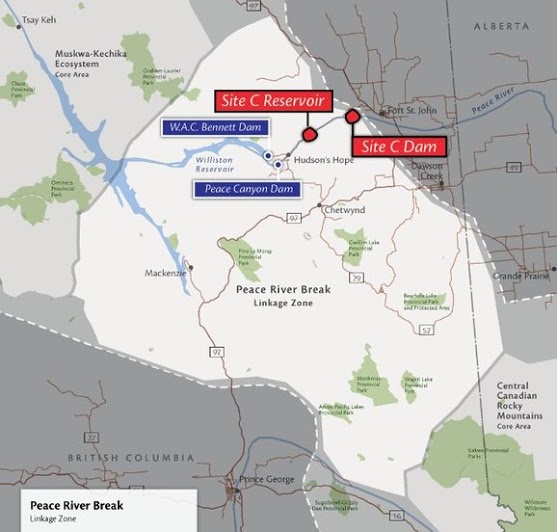
Side by side maps show the location of the the Site C dam within the Yellowstone to Yukon conservation corridor. Images: Yellowstone to Yukon Conservation Initiative.
Stretching more than 3,200 kilometres, the Yellowstone to Yukon region is home to the full suite of wildlife species that existed when European explorers first arrived. Known as the “mother of rivers,” these mountain ecosystems are the source of clean, safe drinking water for up to 15 million North Americans.
This region is an ecologically vital, but threatened, priority area for conservation in this large transboundary landscape. Encompassing parts of many distinct ecosystems, the Peace River Break is a continental crossroads that straddles the Peace River watershed and provides a corridor for migrating birds, caribou and grizzly bears.
But this key wildlife corridor is under great pressure. According to Global Forest Watch Canada, the Peace River Break is experiencing industrial-caused disturbances at rates greater than those found in Alberta’s oilsands region. Intense and accelerating oil, gas and coalbed methane extraction, coal and other mining, forestry and wind energy development act as barriers to wildlife movement and threaten the integrity of the landscape.
Adding to these pressures, the province has begun construction of the Site C hydro dam, which would further erode the landscape’s ability to support wide-ranging species.

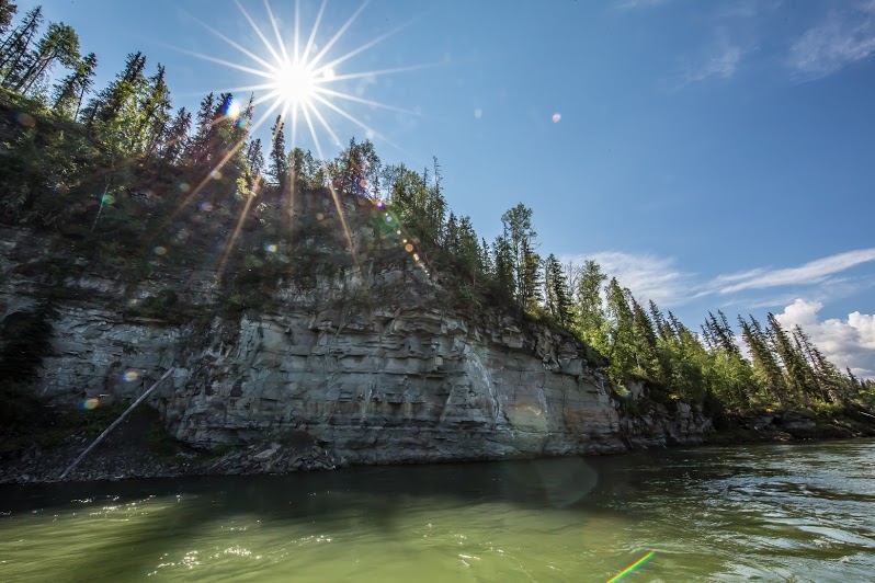
For 12 years running, community members have gathered to paddle the Peace River in opposition to Site C dam, an annual event jointly hosted by the West Moberly First Nations and Peace Valley Environment Association. Photo: Tristan Brand.
Conservation of ecosystems and industrial resource development are woefully unbalanced in the Peace River Break, where just a few protected areas represent a tiny fraction of the region's ecological diversity and only 4 per cent of its land base.
Although approximately 50 per cent of the region has extensive road networks and a widespread industrial footprint, a band of relatively intact land extends north-south along the Hart and Misinchinka Ranges of the Rocky Mountains.
To the east the wetlands and aspen parklands of the boreal plains rise out of the valleys of the Peace and Pine rivers, a northern extension of the Great Plains of North America. To the north, forested hills and green valleys roll away to the deep waters of the man-made Williston Reservoir.

The W.A.C. Bennet dam, constructed in 1968, flooded 350,000 acres of forested land, including sections along the Peace, Finlay and Parsnip rivers. Photo: Tristan Brand.
This highland carpet of green spruce and pine is pierced by the brilliant white pinnacles of Klinse-za — the Twin Sisters mountains — a place of healing and sanctuary to the First Nations that have made their home in the Peace since time immemorial.
This mountain ecosystem includes several undeveloped creek watersheds, intact forests, alpine terrain with no roads, and critical core and seasonal wildlife habitat. It’s a narrow corridor of wilderness that enables wildlife to move between two large, but isolated, regions of protected habitat: the Muskwa-Kechika Ecosystem to the north and, to the south, the major parks of the central Rockies — Jasper, Banff and Kakwa.
Keeping this connection intact is critical for wide-ranging wildlife such as grizzly bears, mountain caribou and wolverines.

Cumulative industrial impacts in the Peace. Image: Global Forest Watch.
Without this link, populations would become isolated over time, may not reach their breeding and wintering grounds, and would not be able to make the long and necessary journeys in search of new homes and mates.
From my perch atop Mount Bickford, I can see this band of intact wildland stretching south from the Pine Pass, and the threats this region’s wildlife face are starkly laid bare.
I can spy coal mines, wind farms, forestry cutblocks and roads, pipelines, transmission lines, and a natural gas plant facility that holds the dubious honour of being the largest single CO2 emitter in B.C.
Given the rapid pace of resource development all around the Peace region, protecting its continentally-significant ecological values has never been so urgent. It’s time to preserve its breathtaking wild landscapes and spectacular wildlife for future generations to enjoy.
Image: Located near Hudson Hope, B.C., these islands are important calving grounds for moose and other ungulates. Photo: Tristan Brand.