


By Ed Struzik. This article was originally published on Yale Environment 360.
Canadian scientist Philip Marsh and I were flying along the coast of the Beaufort Sea, where the frozen tundra had recently opened up into a crater the size of a football stadium.
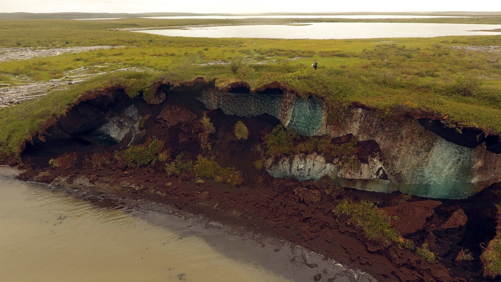
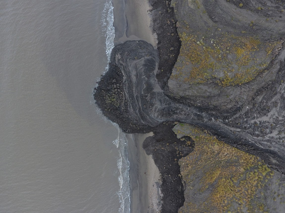
Located along the shoreline of an unnamed lake, the so-called thaw slump was gray, muddy, and barren, in sharp contrast to the brilliant russet and gold of the surrounding autumn tundra. These retrogressive thaw slumps, or landslides — formed as warming temperatures rapidly thaw permafrost — are increasing across the Arctic, including the kilometere-long, 100-meter-deep Batagaika Crater in the Yana River Basin of Siberia.
The tundra of the western Canadian Arctic has long been carpeted in cranberries, blueberries, cloudberries, shrubs, sedges, and lichen that have provided abundant food for grizzly bears, caribou, and other animals.
Now, however, as permafrost thaws and slumping expands, parts of that landscape are being transformed into nothing but mud, silt, and peat, blowing off massive amounts of climate-warming carbon that have been stored in the permafrost for millennia.
A permafrost slump, the size of a football stadium, on the shore of an unnamed lake in the Canadian Arctic. Photo: Ed Struzik / Yale Environment 360
If this had happened in an urban area, it would have resulted in dozens of buildings being swallowed up.
If it had happened along a pipeline right-of-way, it might have resulted in an environmental disaster.
Arctic fastest-warming region on Earth
As the Arctic warms faster than any region on Earth, public attention has largely been focused on the rapid disappearance of Arctic sea ice. But major changes are also taking place on land, and one of the most striking is the thawing of vast swaths of permafrost that have underlain these polar regions for millennia.
That thaw is taking a toll in complex ways that are not clearly understood, and scientists such as Marsh are now intensifying efforts to grasp how these changes will play out this century and beyond.
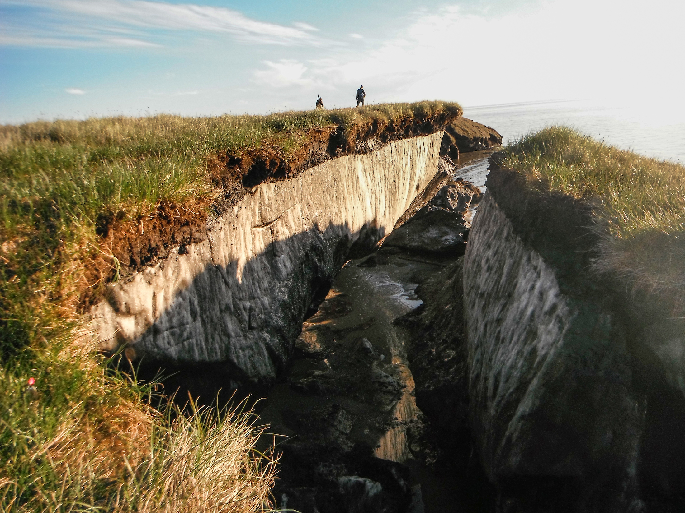
The landscape slumps into the water. Photo: Roger MacLeod / Natural Resources Canada
Exposed permafrost. Photo: Roger MacLeod / Natural Resources Canada
What we do know is that if the Arctic continues to warm as quickly as climatologists are predicting, an estimated 2.5 million square miles of permafrost — 40 per cent of the world’s total — could disappear by the end of the century, with enormous consequences. The most alarming is expected to be the release of huge stores of greenhouse gases, including methane, carbon dioxide, and nitrous oxide that have remained locked in the permafrost for ages. Pathogens will also be released.
But less well appreciated are the sweeping landscape changes that will alter tundra ecosystems, making it increasingly difficult for subsistence Indigenous people, such as the Inuit, and Arctic animals to find food.
‘The frozen ground literally falls apart’
The disintegration of subterranean ice that glues together the peat, clay, rocks, sand, and other inorganic minerals is now triggering landslides and slumping at alarming rates, resulting in stream flows changing, lakes suddenly draining, seashores collapsing, and water chemistry being altered in ways that could be deleterious to both humans and wildlife.
“We’re seeing slumping along shorelines that can drain most of the water in a lake in just days and even hours,” says Marsh, a former Canadian government scientist who is now a professor of hydrology at Wilfrid Laurier University in Ontario.
“It’s not surprising when you consider that as much as 80 per cent of the ground here consists of frozen water. When that ice melts, the frozen ground literally falls apart.”
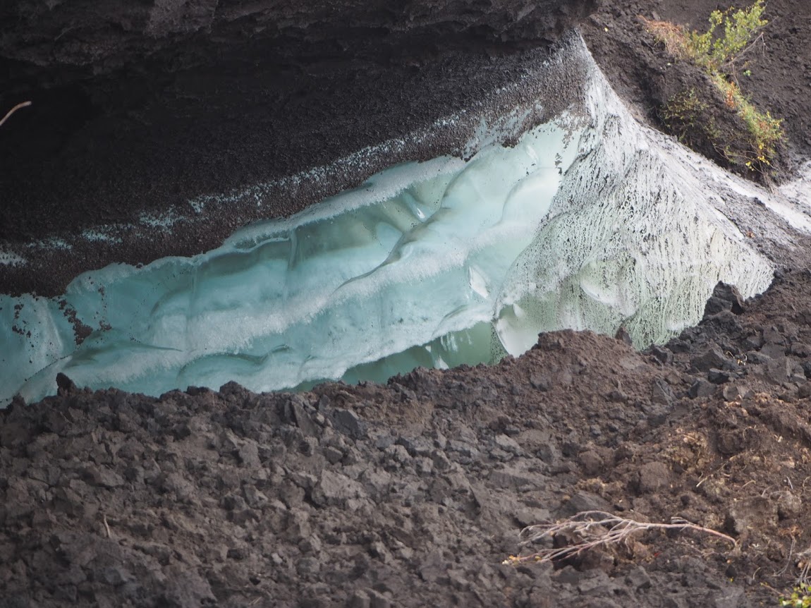
Coastal erosion reveals the extent of ice-rich permafrost underlying the active layer on the Arctic Coastal Plain in the Teshekpuk Lake Special Area of the National Petroleum Reserve, Alaska. Photo: Brandt Meixell / USGS
As a result, says Marsh, Indigenous communities, the resource industry, and the government need to better understand how a warming climate is impacting water resources and permafrost ecosystems.”
As the helicopter pilot circled Marsh’s research site searching for a dry spot to land, I could see the Husky Lakes in the distance. This is a unique treeline/tundra transitional zone where grizzly bears have been known to kill or mate with polar bears and where sea-going belugas swim into brackish inland lakes.
From the helicopter, the research camp below looked like a stick man.
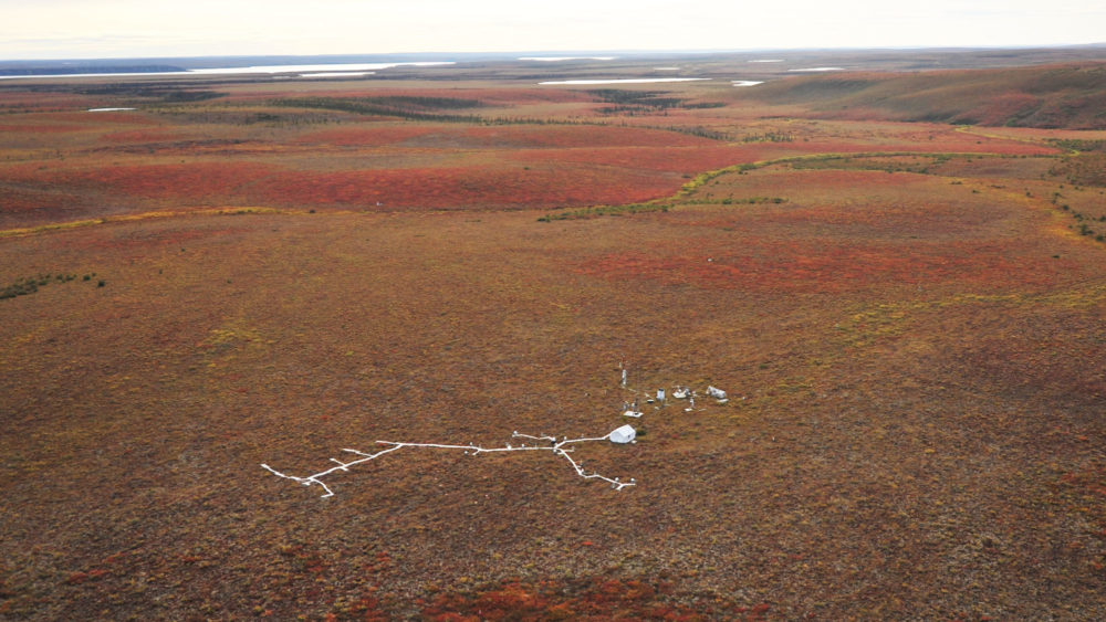
Aerial view of the Trail Valley Creek research station in the western Canadian Arctic, situated along the Mackenzie Delta. Photo: Ed Struzik / Yale Environment 360
Narrow wooden boardwalks connect weather stations, snow, and rain gauges, and instruments that determine how much carbon dioxide, nitrous oxide, and methane are being absorbed by tundra plants and how much of these gases is being emitted into the atmosphere. The boardwalks were laid down so that the scientists’ boots won’t disturb the thawing peat and permafrost or skew the recordings.
Solar panels and a back-up generator kept everything powered, including an electrified fence designed to keep out both grizzly and polar bears.
Marsh, who has conducted field work in the Arctic for more than four decades, established this research station in Trail Valley Creek in 1991. Not only is it situated in the most rapidly warming region on Earth, but it is also the site of a new Arctic highway, hundreds of now-dormant exploratory oil and gas drilling sites, and some of the most important bird nesting territory in the Arctic.
Like all permafrost scientists, he and his colleagues have worked in arduous conditions, fighting off hordes of biting flies and mosquitoes in the summer, and measuring snowpack and ground temperatures in bitter winter cold.
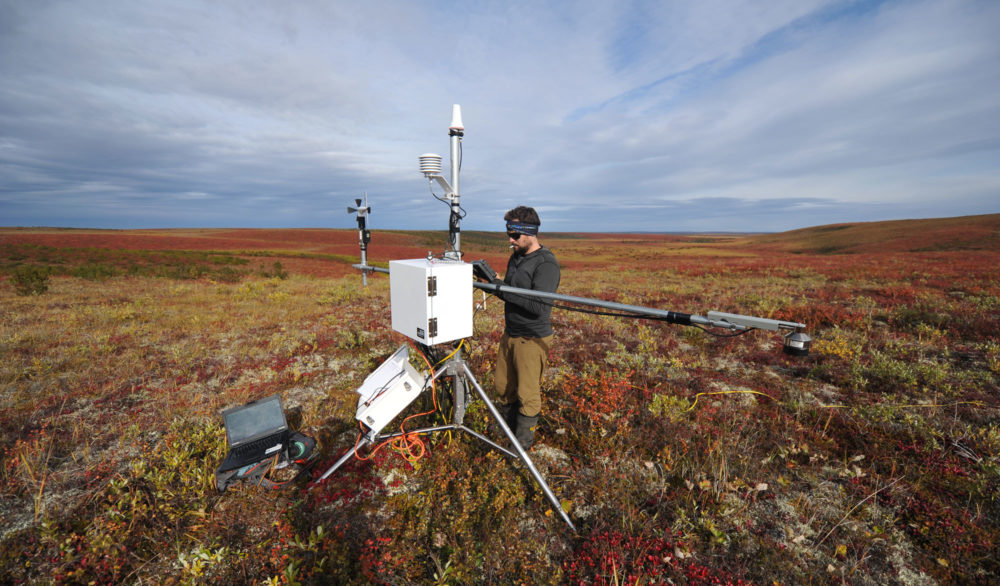
Branden Walker, a researcher from Wilfrid Laurier University, gathers data from a weather station on the tundra in the Northwest Territories. Photo: Ed Struzik / Yale Environment 360
One of the largest carbon sinks in the world
Marsh’s research in the Canadian Arctic has already led him to conclude that climate warming will result in hydrological changes this century that will dry up 15,000 of the 45,000 lakes in the Mackenzie River Delta, one of the largest deltas in the world.
He also expects to see more of what Antoni Lewkowicz, a geographer and permafrost expert at the University of Ottawa, is seeing father north on Banks Island in the High Arctic of Canada. Lewkowicz recently reported a 60-fold increase in slumping along 288 lakes that he has monitored with satellite imagery from 1984 to 2015.
Slumping can occur with sudden catastrophic force.
In one notable case that was captured on time-lapse photography in 2015 by Steve Kokelj, a permafrost expert with the Northwest Territories Geological Survey, a rapidly thawing cliff bordering the shores of a tundra lake collapsed into the Peel River watershed in the Northwest Territories. The waterfall that was created drained approximately 800,000 gallons of water from that upland lake in just two hours.
Heavy metals in the permafrost, such as mercury, were flushed downstream along with silt and peat, tainting the river system for miles downstream.
Permafrost occurs in areas where the temperature of the ground remains below the freezing mark for two years or more. About a quarter of the Northern Hemisphere’s landscape fits this definition.
Most of the world’s permafrost is found in northern Russia, Canada, Alaska, Iceland, and Scandinavia. Much of it underlies peat ecosystems. But like peat, permafrost is also found in the Rocky Mountains of Canada and Alaska, the Alps, the Himalayas, the high-altitude Patagonia region of South America, and the high country of New Zealand.
The rapid thawing of permafrost has enormous implications for climate change. There are an estimated 1,400 gigatons of carbon frozen in permafrost, making the Arctic one of the largest carbon sinks in the world. That’s about four times more than humans have emitted since the Industrial Revolution, and nearly twice as much as is currently contained in the atmosphere.
According to a recent report, a 3.6-degrees Fahrenheit ( 2 degrees Celsius) increase in temperature — expected by the end of the century — will result in a loss of about 40 per cent of the world’s permafrost by 2100.
Greenhouse gases on the tundra are released in two ways. As permafrost thaws, once-dormant microorganisms break down organic matter, allowing methane and carbon to be released in the atmosphere. Thawing can also open pathways for methane to rise up from reservoirs deep in the earth.
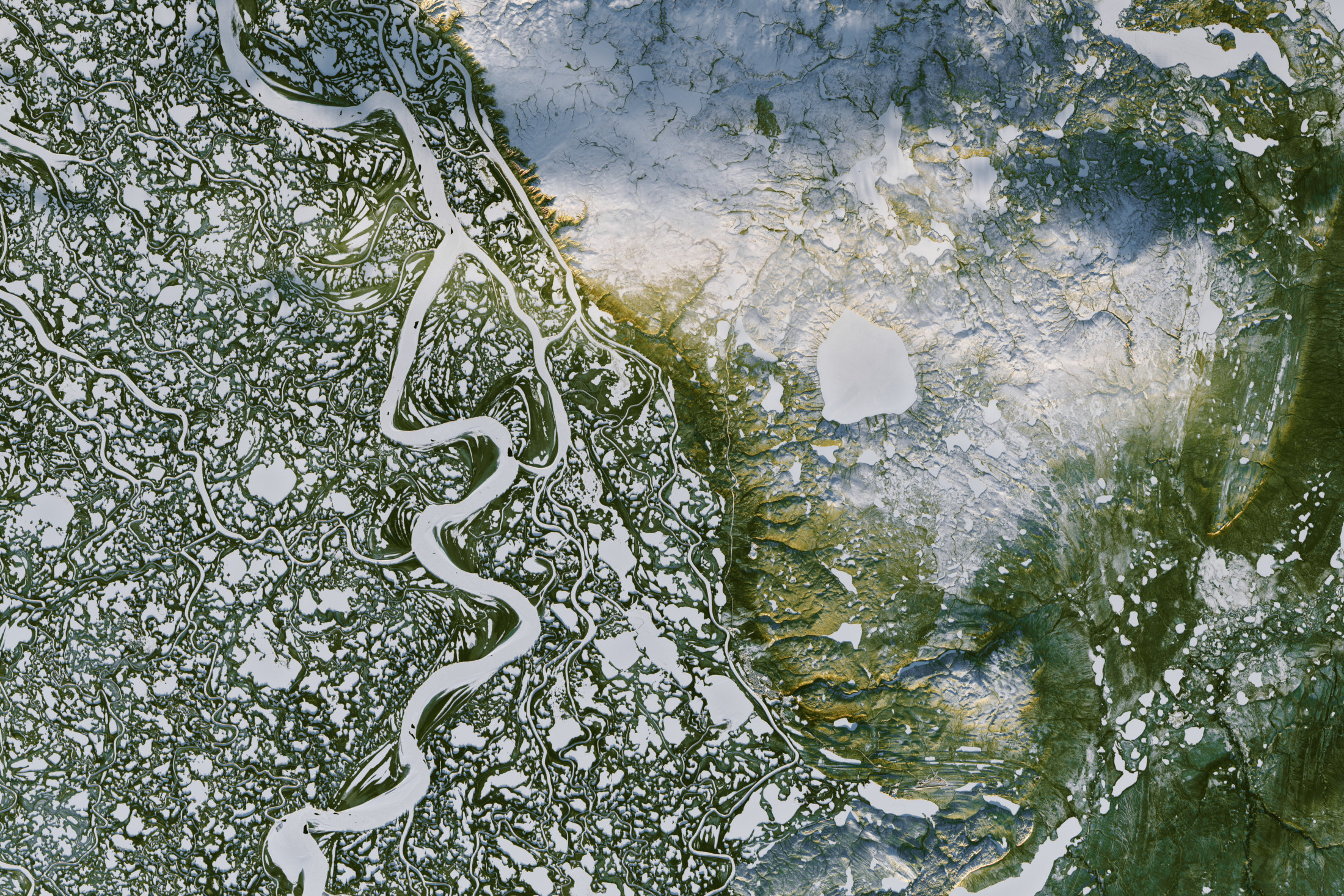
The Mackenzie River system is Canada’s largest watershed, and the tenth largest water basin in the world. Parts of the watershed sit atop permafrost, which makes the area vulnerable to climate change. Photo: Joshua Stevens / NASA Earth Observatory
Once-dormant pathogens coming back to life?
The permafrost thawing that is leading to the release of greenhouse gases is intensifying across the Arctic.
Much of the permafrost degradation that has occurred on Canada’s Banks Island took place after some of the warmest years on record, according to Lewkowicz.
In 1984, the island had 60 active slumps. By 2013, there were 4,000. Lewkowicz expects that the island may see as many as 30,000 new active slumps in the coming years.
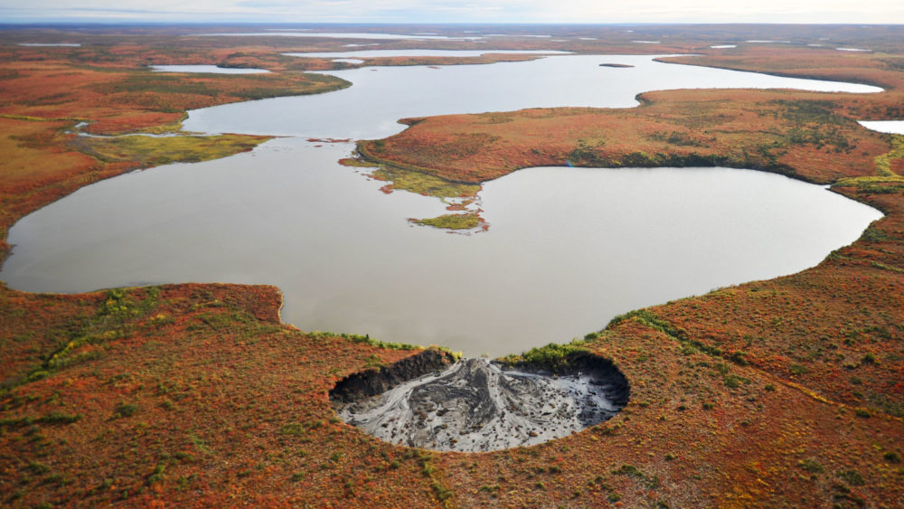
This thawing will have a profound impact on the flow and chemistry of lakes and streams, as well as those parts of the Arctic Ocean into which rivers drain. Lewkowicz’s satellite data, for example, shows that the colour of many of the lakes on Banks Island has changed from blue to turquoise, indicating that the once-clear water has become filled with sediments.
Scientists suspect that some of the slumping may be giving new life to pathogens capable of killing muskoxen, caribou, and nesting birds as warmer temperatures nudge the pathogens out of their dormant state. Massive die-offs of muskoxen on Banks and Victoria islands in Canada, as well as reindeer in Siberia, appear to be related to once-dormant pathogens that are coming back to life.
Scientists are also finding that hundreds of sumps excavated by the oil and gas industry in the 1970s and 1980s are now thawing. Toxic petroleum waste that was supposed to be permanently contained in 200 frozen pits in the Mackenzie Delta, for example, is migrating into nearby freshwater ecosystems.
At Trail Valley Creek, Carolina Voigt, a post-doctoral geography researcher, and Oliver Sonnentag, a hydrologist at the University of Montreal, are using manual and automated sensors to measure how climate change affects greenhouse gas activity on the tundra.
Evan Wilcox, a geography PhD candidate at Wilfrid Laurier University, has made important discoveries about the role that the rapid expansion of shrubs in the Arctic — the result of rising temperatures — is playing in the thawing of permafrost. All across the warming Arctic, shrubs are expanding into tundra where grasses, sedges, and lichens once prevailed. Not only are the taller shrubs shading out the smaller plants below, they are also changing the hydrology of the ecosystem.
“We’re finding that the date when snow melts is the key to determining the rate at which the active-layer permafrost thaws,” says Wilcox. “The snow in tundra areas where you have shrubs such as dwarf birch tends to melt a week earlier than it does in areas where there are no shrubs. This results in more permafrost thawing. As the shrubs expand into the tundra, we’re likely to see an acceleration of thawing.”
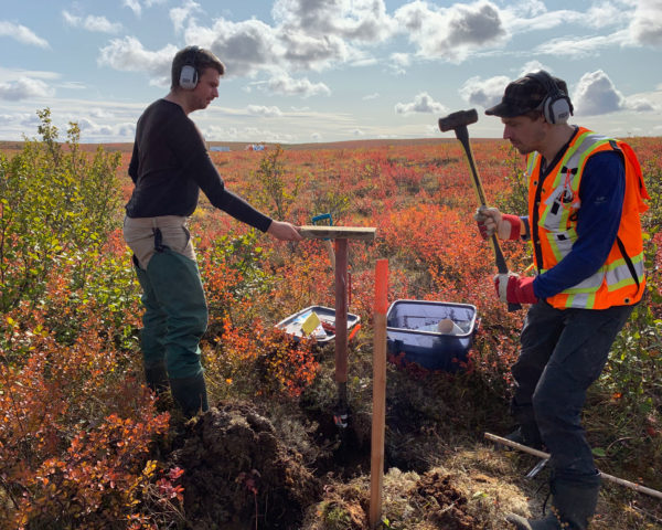
Researchers Evan Wilcox (left) and Niels Weiss extract ice-rich permafrost cores from the tundra. Photo: Ed Struzik / Yale Environment 360
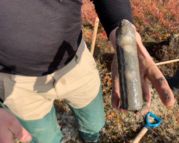
Evan Wilcox holds a permafrost core sample. Photo: Ed Struzik / Yale Environment 360
Wilcox bores steel probes — as many as 3,000 one recent summer — into the ground to determine the depths of ground thaw.
Arduous as that is, Niels Weiss, a postdoctoral fellow working with Marsh, has a much tougher time hammering into the solid ice to get the sample he needs to determine how much and what kind of organic material is contained in the permafrost.
Weiss has conducted permafrost research in Siberia, Scandinavia, and Canada, and he and others have found that carbon storage and the ways gas is released from these ecosystems depend on a variety of factors such as soil composition, groundwater flow, and whether trees, shrubs, or grasses are predominant.
What’s clear, he says, is that even in the coldest places in the Arctic, permafrost is thawing at accelerating rates.
Although much remains to be discovered about the impacts of thawing permafrost in the region, Marsh says one thing is becoming increasingly clear: In the coming decades, the tundra landscape will look much different than it does now.
That change was evident as we bushwhacked through 8-foot-high willows en route to retrieve a water gauge swept away during the spring flood. Thirty years ago, lichen and sedges dominated this landscape. Today, willows and shrubs are proliferating across the tundra. Abundant caribou once fed on the lichen, their numbers on the Tuktoyaktuk Peninsula hitting 3,000 in 2006. Now, only half that number remain.