Connecting the dots between B.C.’s floods, landslides and the clearcut logging of old forests
Deforestation dramatically alters how landscapes are able to cope with extreme weather events like the atmospheric river that surged across southern British Columbia earlier this week
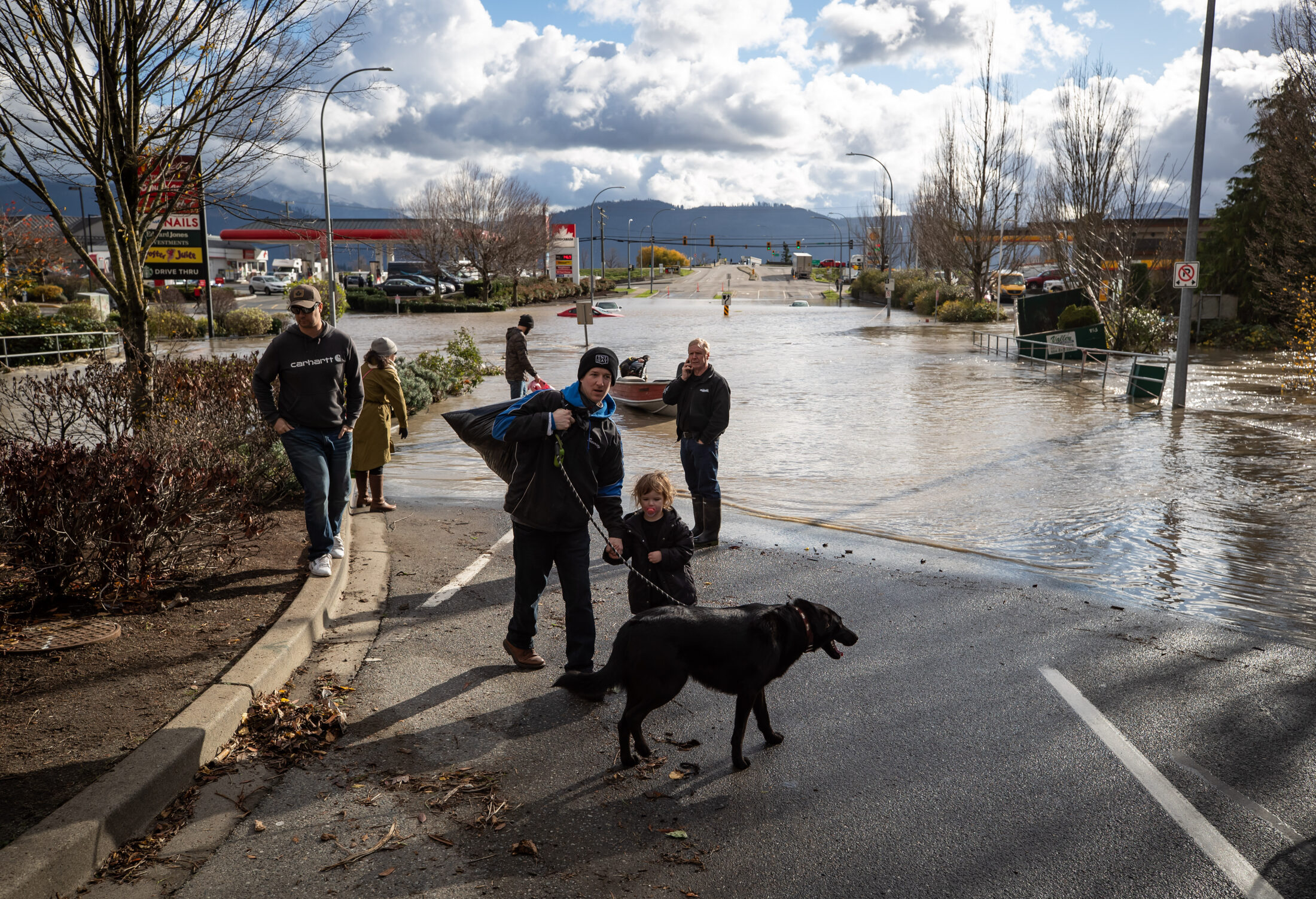
A man, toddler and dog who were rescued by a volunteer in a boat after being stranded by high water due to flooding walk on high ground, in Abbotsford, B.C., on Tuesday, Nov. 16, 2021.
Photo: Darryl Dyck / The Canadian Press
This article is more than 4 years old
The swollen creek, hurtling down a hillside toward Day Road on the Sunshine Coast, carves a path through the tarmac, chomps massive bites out of the road surface and then flings a metal culvert into the air while trees topple into the water.
The video, taken by a bystander, shows a scene that was repeated in communities around British Columbia as a rare weather bomb brought record rainfall and intense winds to the south coast. Roads washed out, landslides swept away vehicles, causing at least one death, and rivers flooded homes and farmland.
As thousands of British Columbians remain displaced and under evacuation orders, the province declared a state of emergency Wednesday. As the full extent of the flood damage across the province is being assessed many are questioning what factors might have contributed to such extensive flooding and mudslides, especially after a summer of deadly heat and devastating wildfires.
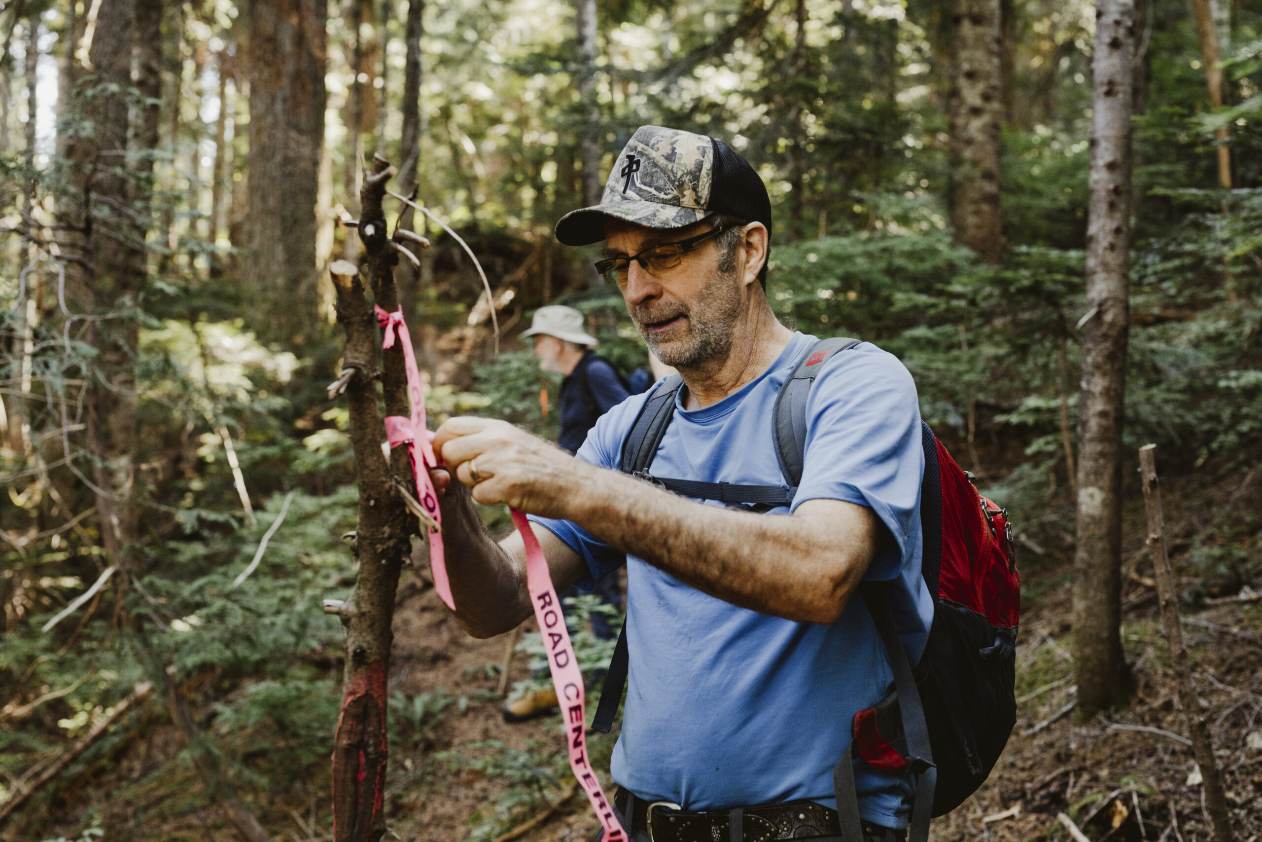
The combination of climate change, clearcut logging and poor forestry practices are being blamed as contributing factors in many communities. On the Sunshine Coast, where Elphinstone Logging Focus (ELF) has kept meticulous records of logging in controversial areas, the Day Road washout did not surprise ELF founder and forest campaigner Ross Muirhead who, before the exceptional storm, photographed plugged culverts and rain washing along logging roads.
“Just last year they completed 60 hectares of clearcutting in about six blocks all connected by 1.3 kilometres of new logging road. The road is at the bottom of the clearcut, so all the water was peeling off the clearcut,” said Muirhead, pointing out that, even in such an extreme event, an intact forest would have intercepted much of the groundwater.
Ross Muirhead, forest campaigner and founder of Elphinstone Logging Focus (ELF), a small Sunshine Coast-based environmental group. Photo: Shayd Johnson / The Narwhal
“The bottom line is that our landscapes have become less resilient to handle these new heavy rainfall events due to human-caused disturbances such as clearcut logging and the associated road building — which has resulted in a huge-fold increase in surface runoff conditions,” said Muirhead, who mapped 10 cutblocks between Gough Creek and Clack Creek — auctioned off by BC Timber Sales — on the slopes above the road that was washed out by both the usually-benign creeks.
Around the Sunshine Coast, concerns extend beyond washed out roads to the effect of sand and gravel from clearcuts washing into wells, said Muirhead, who believes, at the very least, logging contractors should be obliged to figure out how much extra water will flow from clearcuts into communities so municipal staff can figure out whether culverts and roads will be able to cope.
In a letter sent to BC Timber Sales and the forests ministry, ELF is calling for a complete ban on all planned cutblocks and roadbuilding across the Elphinstone and Gibsons slopes. BC Timber Sales has at least seven cutblocks planned above the Town of Gibsons in the aquifer recharge zone, Muirhead said.
B.C. government urged to explore connection between floods and logging
Experts are reluctant to lay the blame for the catastrophic damage solely at the feet of the logging industry and the provincial regulations that allow clearcut logging to continue without consideration of climate change, but most agree that the hydrology of an area changes as soon as the forest cover is removed, whether by logging or fire, and that contributes to floods and landslides.
Peter Wood, author of a report written earlier this year for Sierra Club BC that looked at the relationship between forest management and severe climate impacts, such as droughts and fires, has looked at satellite images showing several of the hard-hit areas were heavily logged.
“I don’t want to jump to conclusions right away, but I think, at the very least, the Forest Practices Board or another government agency should look into this,” he said.
A forests ministry spokesman said in an emailed response to questions from The Narwhal that the link between clearcut logging and floods has been investigated for decades, but studies are often conducted on smaller streams and it is not clear how they apply to large river networks.
“We know clearcut logging can have a significant effect on hydrologic processes at both the forest stand and watershed scales. Loss of forest cover following logging generally results in increased precipitation reaching the ground,” he wrote.
However, the severity of the impacts depend on everything from vegetation type to timing and some studies have concluded that the effects of logging are not significant for very large storms, according to the ministry email.
Wood, who has a PhD in forestry from the University of Toronto, said it is sometimes easy to spot a smoking gun, such as a logging road that has slumped, but, often, it is a much larger problem, involving the entire drainage system, so it is essential to look at cumulative impacts.
If that drainage area has been heavily clearcut or burned, it will contribute more quickly to runoff as a mature forest acts as a giant sponge releasing water over time, he said.
“Even the rainfall that gets caught up in the branches and a billion little needles is an incredible surface area that can just take the rain and moderate the rate at which the rain comes into the river systems,” he said.
Better accountability is needed, with the chief forester taking responsibility for climate risks, such as fire, flooding and landslides, instead of being responsible only for the amount of timber to be harvested, Wood suggested.
“There’s a lot of solid science out there that can tell you how much you can cut within a given drainage without creating risk,” he said.
“On steep slopes maybe a forest can take a few trees being removed and it’s still okay, but then you go past a certain threshold and you are in danger of the whole hillside collapsing,” he said.
Forest clearcut on Vancouver Island. Experts say clearcut logging on steep terrain can contribute to slope instability. Photo: TJ Watt
‘You take off the trees, you end up with more water in your soil and you get those slides’
Watershed geoscientist and hydrologist Kim Green, an expert in the impact of forestry on snow melt regions, said logging affects the frequency and magnitude of floods because it changes the way the soil behaves, especially if there have been successive rain events before a big storm.
“Without question, the removal of forests both increases the frequency of landslides and frequency of flooding,” she said, explaining that, as roots rot after trees are removed, they create conduits for water.
“You take off the trees, you end up with more water in your soil and you get those slides,” she said.
Forest ecologist Rachel Holt, a member of the province’s Old Growth Technical Advisory Panel and author of two technical reports criticizing the province’s management of old-growth forests, said ecologists and hydrologists have warned for decades that clearcuts radically change how water runs off slopes.
Climate change means more help is needed from forests which store massive amounts of carbon and moderate how water lands on the ground and flows off the hillsides, but, instead, the opposite has happened, she said.
“We’ve been managing for timber at the expense of all the other values such as biodiversity and climate mitigation and climate adaptation. … The pressure on the system has been increasing with climate (change) and, at the same time, we’ve increased the harvest over the last 30 years,” Holt said.
“So, what do we do? We radically lower the harvest level. Leave the forest standing on the ground to do its job. Then we stop clearcut harvesting and go to partial harvesting across the board. … This is not radical. We’ve known this for 30 years and started doing it and then we stopped with the change in government,” she said.
In 2001 the BC Liberals scrapped the prescriptive Forest Practices Code and, instead, brought in rules allowing companies to use their own professionals to decide whether they were meeting broad objectives.
Areas that have been devastated around Princeton and Merritt are surrounded by heavily logged landscapes, Holt pointed out.
A Google Earth timelapse video shows the extent of logging between 1984 and 2020 around Merritt, B.C., a city inundated with floodwaters after recent unprecedented rain. Video: Google Earth
“The combination of bog-standard forest management, combined with mountain pine beetle means the rate of removal of forest cover has been phenomenal in the last 30 years, so the amount of flow that can happen very, very quickly off those hillsides is huge,” said Holt, who expects to see court cases launched by those affected by the floods and landslides.
In Grand Forks, which was devastated by floods in 2018, a group of residents has filed a B.C. Supreme Court lawsuit against the forests ministry and logging companies, claiming over-harvesting in the Boundary and Okanagan forests significantly contributed to the flooding.
A second lawsuit has been launched by the same group against the West Boundary Community Forest Inc., which holds harvesting rights to about 18,000 hectares of forests around Grand Forks.
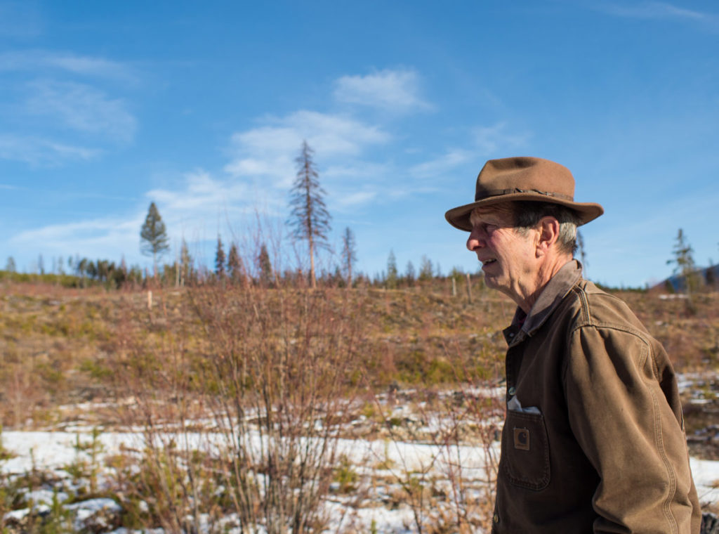
Retired forester Fred Marshall, a woodlot owner and forestry consultant from the Boundary region, said the Grand Forks floods and recent disasters prove the validity of the many research studies showing B.C.’s clearcuts affect the hydrological regime.
But naysayers continue to refuse to accept the truth that cutting down forests has serious ramifications and the provincial government has been aggressively on the same side as the clearcutting companies, so has not held them accountable, Marshall said.
“Hence, the people of B.C. suffer the consequences and pay for them while the forest industry does neither and demands to keep creating the clearcuts,” he said.
Fred Marshall, a retired forester, in his home near Greenwood, B.C. Marshall believes one of the main causes of the 2017 and 2018 floods in Grand Forks was excessive clearcutting in the many watersheds that feed into the Granby and Kettle river systems. Photo: Louis Bockner / The Narwhal
Taryn Skalbania of Peachland, a long-distance horse rider and founding member of the B.C. Coalition for Forestry Reform, was spurred to action after discovering forestry companies were entitled to clearcut in the community watershed, threatening drinking water and wiping out trails, but the municipality and community organizations had “zero control.”
“We were told that past and current logging is definitely affecting our drinking water and recreational trails and roads and sedimentation. However, all those activities are legal and they hadn’t broken any laws. Then we really decided we have to change the laws that govern communities,” Skalbania said.
There is a wealth of evidence about how clearcutting exacerbates wildfires as well as floods and landslides and, with this week’s events, the urgency of the situation is becoming apparent, said Skalbania, who, with her livestock, has been evacuated from her home three times.
“Will the already-subsidized forest industry pitch in for the collateral damage?” she asked.
“When our government is rewriting forest policy they should be writing it firmly and immediately to save our forests, our first line of defence against mudslides, floods and climate change. … If they (the companies) can’t do it right, it should be back to the drawing board,” she said.
As the province struggles toward recovery, for many the question is what happens as climate change continues the march toward warmer temperatures.
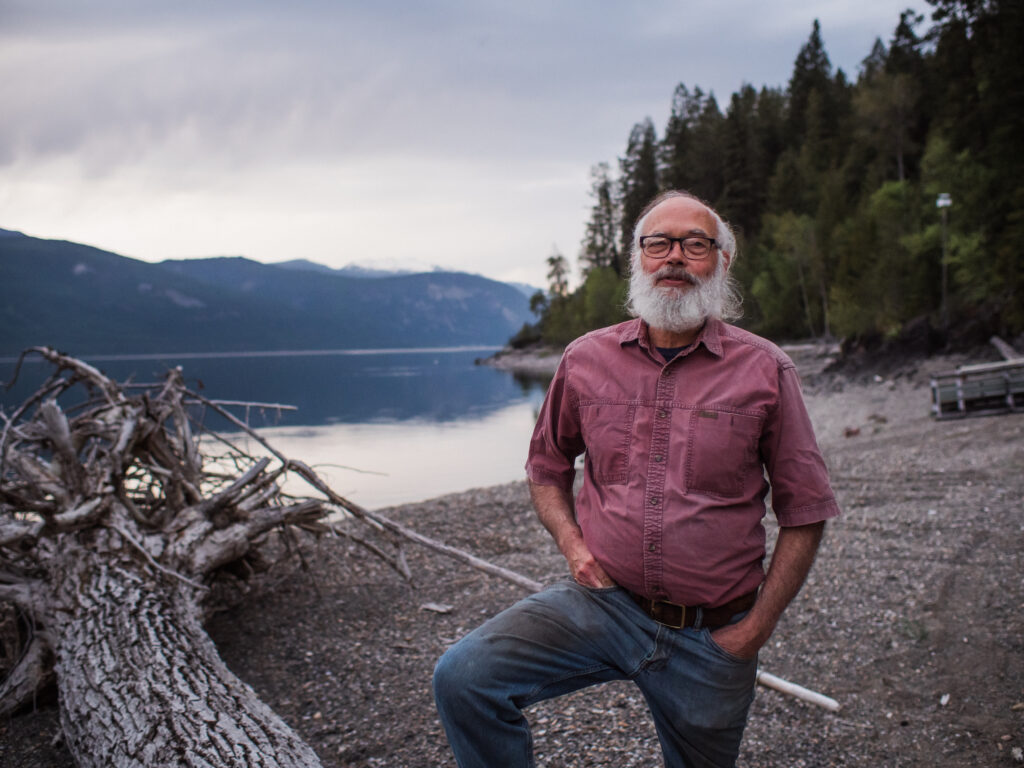
Conservation ecologist Greg Utzig said the kinds of floods and landslides being seen in B.C. were predicted in studies he co-authored decades ago. “This is not unexpected, it’s just unfortunate and it is just the start,” he said. Photo: Louis Bockner / The Narwhal
Conservation ecologist and agrologist Greg Utzig, who specializes in landslides and terrain mapping, said floods, fires and landslides were predicted in climate studies written by him and Holt a decade ago and have been discussed for at least three decades.
Logging roads, bridges and culverts are not built to withstand the type of storm that hit B.C. this week and fires this summer contributed to creating water-repellent soil, he said.
“This is not unexpected, it’s just unfortunate and it is just the start,” Utzig said.
“Right now we have warmed the earth by one degree, maybe 1.1 degrees [Celsius], and we’re headed for 2.4,” he said.
Jens Wieting, Sierra Club BC forest and climate campaigner, said time is running out to make changes.
“We have degraded landscapes with much less vegetation and a shifting climate with more than one degree of global warming translating into about seven per cent more water vapour in the atmosphere” he said.
“With the heat dome this summer and now the flooding we really have a spectacularly unfortunate combination of shifting baselines and we are still continuing with business as usual,” he said.
Government must speed up the process of reforming forestry and adopting recommendations from the recent Old Growth Strategic Review as industrial logging is threatening lives and communities, said Wieting, who would like to see a climate risk test for all logging proposals.
Some plans must be cancelled or drastically revised to ensure more lives are not put at risk, Wieting said.
Updated Nov. 18, 2021 at 9:35 a.m. PT: This article was updated to clarify a quote from Jens Wieting to indicate that one degree of global warming translates into seven per cent more water vapour in the atmosphere.
Another year of keeping a close watch
Here at The Narwhal, we don’t use profit, awards or pageviews to measure success. The thing that matters most is real-world impact — evidence that our reporting influenced citizens to hold power to account and pushed policymakers to do better.
And in 2024, our stories were raised in parliaments across the country and cited by citizens in their petitions and letters to politicians.
In Alberta, our reporting revealed Premier Danielle Smith made false statements about the controversial renewables pause. In Manitoba, we proved that officials failed to formally inspect a leaky pipeline for years. And our investigations on a leaked recording of TC Energy executives were called “the most important Canadian political story of the year.”
Your access to our journalism is free, always. Sign up for our newsletter for investigative reporting on the natural world in B.C. — and across Canada — you won’t find anywhere else.
Your access to our journalism is free, always. Sign up for our newsletter for investigative reporting on the natural world in B.C. — and across Canada — you won’t find anywhere else.