


This article originally appeared on Policy Note.
Massive amounts of water pumped with brute force into the earth at thousands of fracking operations is priming the pump for potentially deadly earthquakes in British Columbia’s Montney basin, warns a former top scientist with B.C.’s Oil and Gas Commission.
In a peer-reviewed article published today in the Journal of Geoscience and Environmental Protection, Allan Chapman, a former hydrologist with the commission, says that it is not single, errant fracking operations that explain why many earthquakes have already occurred in B.C. and will occur in the future, but the “cumulative development” or fracking of thousands of wells.
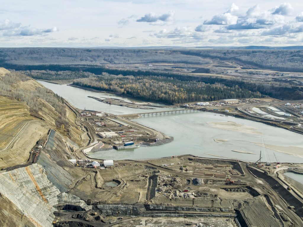
And he warns that the surge in fracking-induced earthquakes that lies ahead poses serious risks to communities and critical infrastructure in the Peace River region — including the Site C dam, an aging bridge and critical lifeline to the north and a massive gas processing plant.
Like the straw that breaks the proverbial camel’s back, at some point a dangerous tipping point is reached, Chapman concludes, adding that the commission’s current approach to preventing earthquakes from occurring isn’t working and will have to change to reduce the risk of future calamities.
“The future in the Montney is not if M>5 [magnitude 5 or greater] earthquakes will occur, but when, with that occurrence possibly without any precursor warning,” Chapman reports in the paper, adding that the fossil fuel industry’s ongoing “experiment” with fracking poses significant public health and safety risks and should be regarded as “an issue of paramount concern.”
Communities in the crosshairs?
“At any point of the day, in the middle of the day or the middle of the night, life as folks in the Peace region know it could be altered forever. The ground could shake. Roofs could come down. People could be injured, possibly seriously. Bridges can collapse. All kinds of things can happen, none of them good,” Chapman said in an interview, adding that two of the most at-risk communities in the region are Taylor and the isolated First Nation community of Upper Halfway.
Chapman’s work is grounded both in science and a distinguished public service record that includes nearly eight years as the commission’s top water scientist, and before that, eight years as head of the province’s River Forecast Centre where he assessed potential flood risks and provided early warnings to at-risk communities. In 2014, the Association of Engineers and Geoscientists named him its Westerman Award winner, the top honour for geoscientists in the province. He is now retired from public service and working as a consultant in Victoria.
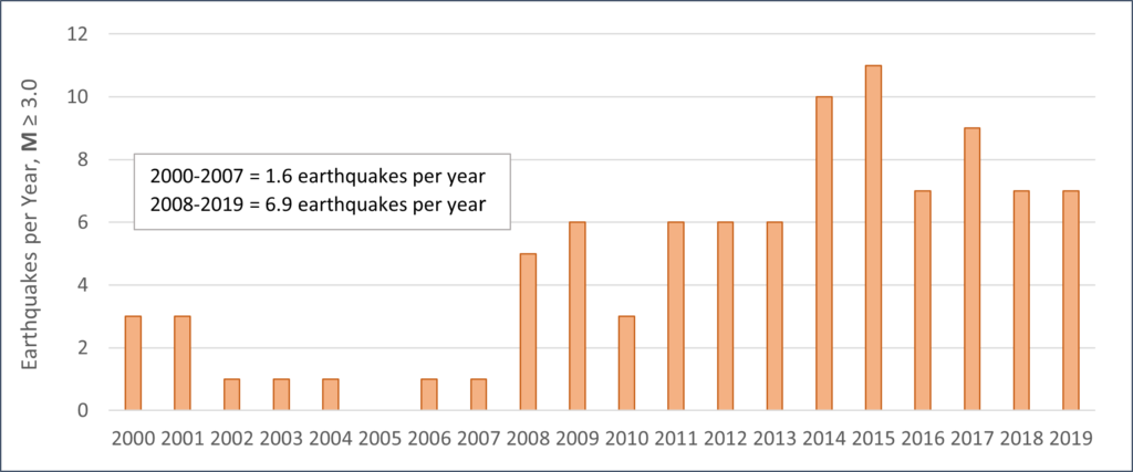
During hydraulic fracturing or fracking, immense volumes of water, sand and chemicals are blasted down wellbores to fracture the surrounding rock so that it releases its trapped natural gas and valuable liquids like condensate. The brute-force technology has triggered earthquakes everywhere it is deployed, including the Montney, a 26,600-square-kilometre region extending from south of Dawson Creek to 200 kilometres north of Fort St. John. Those induced earthquakes have prompted a flurry of academic research in recent years — but Chapman’s may be the first to so clearly spell out the mounting risks associated with one fracking operation after another.
On November 29, 2018, a trio of earthquakes was seemingly touched off at a fracking operation conducted by Canadian Natural Resources Ltd., or CNRL, at a well pad carved out of grain fields owned by one of the Peace region’s two large Hutterite communities. Nearby fields had also been turned into huge pits to store water used by fracking companies operating in the region.

The initial 4.6 magnitude earthquake was felt by residents in their homes in Fort St. John and in Chetwynd, more than 80 kilometres away. Esther Pedersen, who raises horses on acreage overlooking the Site C dam construction project, recalls being at home in her kitchen when the earthquake struck. She called it “a counter grabber.” A “strong jolt” was also felt at Site C, prompting BC Hydro to order an immediate evacuation of hundreds of construction workers. Two other earthquakes followed, one a magnitude 4, the other a magnitude 3.4.
In the immediate aftermath of the event, the commission ordered CNRL to cease all fracking operations at the site.
Understanding the impacts of cumulative fracking activities
But was it CNRL and CNRL alone that was behind all the drama?
To better understand the insidious way that multiple fracking operations can lead to seismic events, Chapman looked closely at 56 earthquakes in the Montney that had magnitudes of 3 or more. Thousands of smaller earthquakes are associated with fracking activities, but Chapman chose to narrow his primary focus to only those earthquakes large enough in magnitude to be felt by people.
Using data from Natural Resources Canada, he pinpointed each earthquake epicentre on a map, and then drew a five-kilometre radius around each one. Then he used water data from the commission to look at all the water pumped over time in fracking operations within the wider zones. (Fittingly, one of Chapman’s first actions upon joining the commission in 2010 was to require that all fossil fuel companies operating in the province file quarterly reports on how much water they used to frack.)
Analyzing site-specific information on cumulative fracking activities, Chapman reached a far different conclusion about what led to the dramatic events in late November of that year.
In the days immediately leading up the cluster of strong earthquakes, Chapman found, CNRL pumped the equivalent of nearly six Olympic swimming pools of water into two well bores 20 kilometres to the north of Site C.
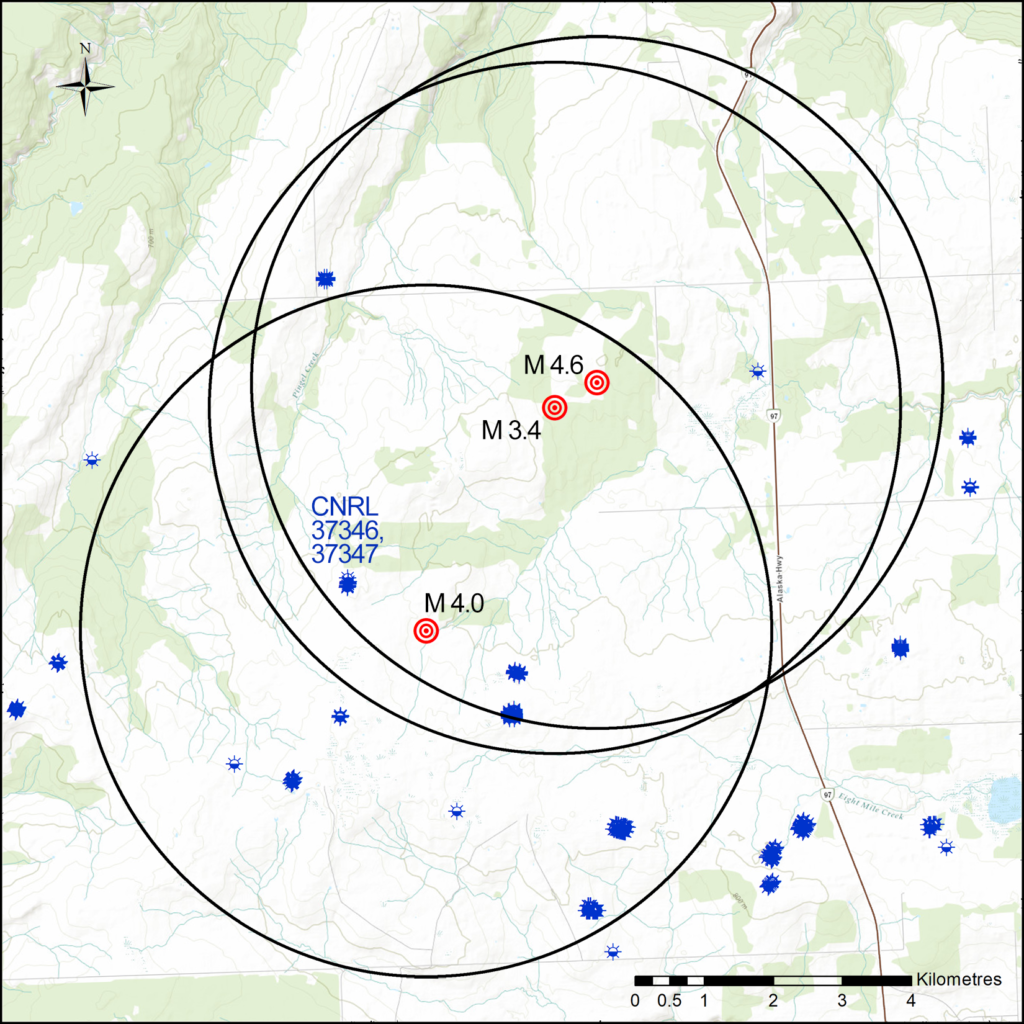
But that water use paled in comparison to the 688 Olympic swimming pools worth of water that four companies including Ovintiv (formerly Encana), ARC Resources, Crew Energy and CNRL had already blasted underground at 109 other gas wells within five kilometres of the earthquake epicentres in the previous three years. When CNRL then added those last six Olympic swimming pools worth of water to the mix, it was like “the proverbial straw that broke the camel’s back,” Chapman concludes. In a subsequent interview he said that the case that cumulative effects are behind the earthquakes becomes even more compelling when you expand the radius by just two more kilometres. Then, the total amount of water used in the fracking operations nearby CNRL’s wells rises to an astonishing 2.93 million cubic metres and the number of fracked wells climbs to nearly 200.
Chapman also looked closely at the events surrounding a 4.6 magnitude earthquake, then the largest ever recorded in B.C., which was set off three years earlier at a Petronas fracking operation near Pink Mountain north of Fort St. John. In the week before the strong earthquake on August 17, 2015, Petronas had pumped 67,625 cubic metres of water into three gas wells, Chapman reports. But in the two years prior, the same company had injected more than four times as much water into another 13 wells within five kilometres of the eventual earthquake’s epicenter.
‘Things get worse over time’
“Things get worse over time,” Chapman said in an interview, noting that the earliest fracking operations do not appear to trigger many earthquakes but as time marches on they do. “It appears that once certain volumes of water are pumped underground that the geology is seeded such that earthquakes result more readily from fracking.”
Gail Atkinson, a renowned expert on the dangers posed to critical infrastructure such as major hydroelectric dams by induced earthquakes, is an earth sciences professor at the University of Western Ontario. Her work has highlighted how earthquakes induced by fracking can have more serious consequences for critical infrastructure than naturally occurring earthquakes because of the relatively shallower depths at which induced events occur. The nearer to the surface the earthquakes are, the closer that puts the ensuing shaking to dams and other vulnerable infrastructure.
Her work has been instrumental in convincing TransAlta, a company that owns and operates dams and other power facilities, to push for a fracking exclusion zone near its Brazeau dam in Alberta, an effort now being fought by fracking companies operating in the region.
“If you have an exclusion zone you’ll keep the cumulative effect out of a certain area,” Atkinson said in an interview. “What Allan Chapman’s article points to — and what we’ve also seen in observations in the articles we’ve been working on — is that once you start something going it’s easy to retrigger things. You’ll be fracking in an area, nothing much is happening, and then things start to pop off. And then it seems that everything you do is making things pop off. And that agrees with Allan’s basic idea that it is a cumulative effect.”
To reduce the risk of “priming the pump” and triggering earthquakes near vulnerable infrastructure, Atkinson says, you need to establish firm no-go zones where fracking is banned. But that’s a big challenge now because both the B.C. and Alberta governments have effectively sold off rights to drill into the subsurface just about everywhere that oil or gas can conceivably be found.
As detailed in documents obtained through freedom of information requests by the Canadian Centre for Policy Alternatives, dam safety officials and engineers with BC Hydro have specifically sought such bans near their W.A.C. Bennett, Peace Canyon and Site C dams, out of concerns that nearby fracking operations could trigger earthquakes that damaged the dams, or, in the worst case, led to a dam failure, an outcome that would have catastrophic impacts for thousands of people living downstream.
But the hydro utility’s efforts have yet to convince the Commission or provincial government to establish firm no-go zones, perhaps because of the compensation costs that the government would have to pay out to the companies it sold the subsurface rights to.
Water use in fracking going up over time
“This whole thing could have been avoided if there’d been a little bit more foresight on the behalf of those who were selling the rights to these subsurface properties and they simply had avoided making those sales,” Atkinson says. “B.C. did it. Alberta did it. They … sold leases without regards to the locations of critical infrastructure. And [now the companies have] put money into both buying those leases and into research and development to figure out whether there’s oil and gas there. And now that they’ve invested all of that money, they want to reap the profits.”
Chapman concludes that a total of 439 earthquakes recorded by Natural Resources Canada in the Montney region between 2013 and 2019, had a “close association” with fracking and that the overwhelming majority of them — 77 per cent — were linked to the fracking operations of just three companies led by Petronas with 209 associated earthquakes, Tourmaline Oil with 79 and Ovintiv (formerly Encana) with 38.
Petronas, which is a significant partner in the proposed LNG Canada facility, has such a high number of earthquakes associated with its operations partly because it operates in the northern portion of the Montney, which is geologically distinct from the more southern portion of the basin and treated as such by the commission. Petronas is also the largest subsurface rights holder in the province and holds a monopoly position in the north Montney, Chapman found.
Chapman also found that 15 per cent of fracked gas wells in the Montney are associated with earthquakes, and that nearly 2 per cent of all fracked wells are associated with earthquakes that are magnitude 3 or stronger.
That is of concern because while the pump may already be primed for earthquakes of potentially great magnitude in northeast B.C., the fracking companies are only just getting started in the Montney.
Chapman notes that between 2012 and 2019 a total of 39 million cubic metres of water — enough to fill 15,600 Olympic swimming pools — was blasted into the earth in the Montney. During that same timeframe, there was also a steady increase in the amount of water used per fracked well. From an average of just over 7,000 cubic metres of water per well in 2012, to more than 22,000 cubic metres by 2019.

When individual companies are looked at, the picture is even more complex. ConocoPhillips, for example, used 83,000 cubic metres of water at each of 13 wells it fracked in 2019. “It is not known whether ConocoPhillips is an outlier or a harbinger,” Chapman wrote. However, he notes that four other fracking companies each used 30,000 cubic metres of water or more per well in 2019, a trend that may not bode well for future frequency and severity of earthquakes.
Protocol system in B.C. not designed for fracking-induced, ‘runaway’ earthquakes: Chapman
To understand what lies ahead, Chapman says it is worth considering the very large well pads that the industry has built in the Montney. Carved out of what were once tracts of boreal forest or plunked down in farmer’s fields in the provincial agricultural land reserve, those pads are generally designed to accommodate 20 or more fracked wells. At one monster pad built recently by Ovintiv, on farmland not far from the community of Taylor, up to 56 wells could eventually be drilled and fracked.
Right now, on average, most of the 639 “multi-well” pads in the Montney have just over 4 wells per pad on average.
Should the Coastal GasLink pipeline and LNG Canada plant be built, there will be an explosion in fracking activity in northeast B.C. as the province becomes a liquefied natural gas exporter.
To give an idea of what lies ahead, Chapman estimated that it would take the “equivalent water volume of as many as 100,000 Olympic-size swimming pools” to fill out those 639 multi-well pads with an average of 20 wells each. That almost certainly would result in not only more earthquakes, but stronger earthquakes.
According to a recent scientific panel that reported to the provincial government, there is no scientifically credible way to predict how large future induced earthquakes may one day be. Their strength will only be constrained by the unique geological conditions in which they occur.
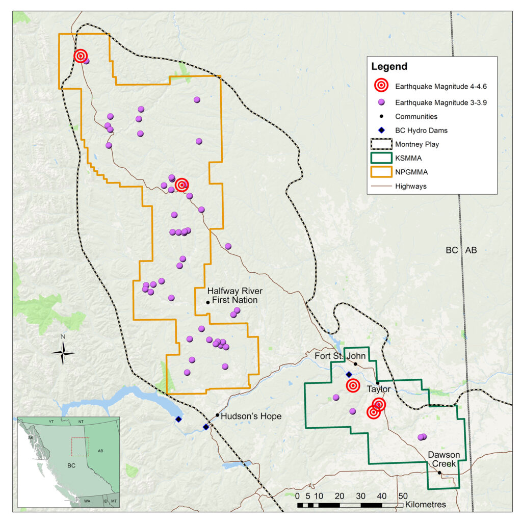
At present, the only tool that the oil and gas commission employs to reduce earthquake risk is a “traffic light protocol,” that calls for the suspension of fracking if a magnitude 4 or greater earthquake is triggered in the Montney. The protocol is somewhat more stringent in the southern portion of the Montney, in an area the commission calls the Kiskatinaw Seismic Monitoring and Mitigation Area or KSMMA. There, the threshold is set at magnitude 3. Named after the nearby Kiskatinaw River, the KSMMA is a hot zone for fracking.
In the traffic light protocol, suspension equals a red light.
The traffic light protocol also calls for mandatory reporting of smaller earthquakes if they reach certain lower magnitudes and for various “mitigation efforts” to be undertaken when those earthquakes occur to theoretically prevent bigger earthquakes.
This is like approaching a yellow light and proceeding with caution.
Unfortunately, Chapman says, the protocol system has not prevented higher magnitude earthquakes from being triggered by fracking. Roughly a third of the larger “induced” earthquakes in the Montney were not preceded by any smaller earthquakes. He adds that if such systems are to work they may have to dramatically lower the magnitudes at which fracking-induced earthquakes trigger red or yellow lights.
Just such a proposal has been made recently by four scientists at Stanford University, led by geophysicist Ryan Shultz. In the paper, the scientists say tougher traffic light systems may be necessary to prevent “runaway earthquakes” and the considerable damage they could cause.
The commission, which received a copy of Chapman’s report the day before its publication, was asked to comment on Chapman’s conclusion that the traffic light protocol had not prevented earthquakes from occurring, an issue it chose not to answer directly.
Instead, it stood by its decision to implement the traffic light system that it had put in place in the Kiskatinaw area in particular, and added that it had also worked with unidentified partners to increase the number of public seismic monitoring stations in northeast B.C. from 11 to 22.
“The commission has taken a leadership role in the detection and mitigation of induced seismicity associated with oil and gas development — in North America and globally. Our geologists and seismic experts use sound, peer-reviewed research, data and predictive modelling to understand, regulate and mitigate seismic activity,” the commission said, in part, referring to ongoing work it is doing on induced earthquakes with researchers at McGill and the University of Calgary.
A cautionary tale – deadly earthquakes in China
But ongoing research aside, Chapman warns that earthquakes like the 5.7 and 5.3 magnitude events that occurred in China’s Sichuan province in 2018 and 2019 could occur in northeast B.C. Those two events in China killed two people, injured many more, destroyed or badly damaged 400 houses, caused millions of dollars in damages and triggered landslides.
His list of communities and critical infrastructure that require “enhanced” protections, which could include “no-fracking zones” or much tighter controls on fracking in proximity to at-risk communities and assets, is long and includes:
· The communities of Dawson Creek, Fort St. John, Taylor, Hudson’s Hope and the Halfway River First Nation community of Upper Halfway among others.
· BC Hydro’s two existing dams on the Peace River — the W.A.C. Bennett and Peace Canyon dams — as well as the Site C dam under construction and years away from completion.
· Community water supplies and treatment plants.
· The Taylor gas plant and the Taylor bridge.
· Dozens of earthen dams built without permits by oil and gas companies to capture water used in their fracking operations.
At the end of his paper, Chapman concludes that “British Columbia’s experiment” with fracking gas well after gas well has resulted in the province having “the sobering distinction of having produced some of the world’s largest fracking-induced earthquakes.”
The provincial government, in his view, owes a duty to the public to ensure that future earthquakes triggered by fracking do not kill and maim people and badly damage or destroy vital infrastructure.
“Part of what motivated me to write this paper was to put the focus on the risk to the people in these communities and the infrastructure that’s in these high-risk areas,” Chapman said in an interview. “I very strongly believe that the primary function of government should be to protect the people that it’s governing.”
Updated April 27, 2021, at 12:18 p.m. PT: This article previously incorrectly stated the Taylor bridge is a suspension bridge. The original Taylor bridge, which collapsed during a landslide in 1957, was a suspension bridge. The bridge built to replace it was not.