‘North of North’ star Anna Lambe believes (most) people can change
From True Detective to The Grizzlies, the Inuk actor is known for badass roles. She's...
If an ocean valley becomes federally protected but seismic work and offshore drilling is allowed in more than 80 per cent of the territory, is it really federally protected?
That’s the question facing Canada’s Department of Fisheries and Oceans, which is currently working on the final regulations for the 11,619 square kilometre Laurentian Channel Marine Protected Area off the southwest coast of Newfoundland.
The proposed regulations published on June 24 in the Canada Gazette included significant allowances for offshore oil and gas exploration and drilling, as well a reduction by more than one-third in the actual size of the Marine Protected Area (MPA) from the original area plotted out in 2007.
The government admitted the regulations came about after fossil fuel lobbyists “raised concerns with respect to limitations on potential future activities.”
The proposal came as a shock to conservation specialists, who contend industrial activities contradict the protected area’s conservation goals.
“We have felt the federal government has been much more willing to concede to industry interests and concerns as opposed to listening to the scientists who are making the recommendations about the high standards of protection that are needed for the site,” said Sigrid Kuehnemund, marine biologist and lead specialist for oceans with World Wildlife Fund Canada, in an interview with DeSmog Canada.
The window for public comment on the proposed regulations closes July 24. The World Wildlife Fund, LeadNow and the Canadian Parks and Wilderness Society are rallying comments before the deadline.

The Laurentian Channel between New Brunswick and Newfoundland is home to a deep-sea canyon that is 1400 km long — more than three times as long and almost twice as wide as the Grand Canyon. Map: NRCan.
If such concessions remain in the enacted regulations they would allow seismic surveying during an eight-month window in the “core protection zone” and full oil and gas activities in the much larger “adaptive management zone.”
Such a decision would also set the tone for Marine Protected Areas to come.
“Because it is so big and well known, the Laurentian Channel MPA is going to set a precedent for the rest of the MPA network in how we meet that 10 per cent commitment,” said Emilie Novaczek, a marine conservation biologist and PhD candidate in geography at Memorial University of Newfoundland, in an interview with DeSmog Canada.
“I think it’s really important we get this one right so the rest of the network can follow suit.”
Canada’s oceans are almost entirely unprotected.
A 2016 report by the Canadian Parks and Wilderness Society reported that a mere 0.11 per cent of the country’s ocean territory is covered with an implemented “Marine Protected Area,” the oceanic equivalent of a national park. Incredibly, eight out of the 23 — or over one-third of the protected areas in the country — don’t explicitly prohibit oil and gas activity.
Meanwhile, only nine of the MPAs prohibit all forms of fishing.
That’s why it was a very big deal when the federal Liberals pledged to increase Marine Protected Area coverage to five per cent by 2017 and 10 per cent by 2020, in line with targets set by the UN’s Convention on Biological Diversity.
In addition, the Liberals promised to “use scientific evidence and the precautionary principle, and take into account climate change, when making decisions affecting fish stocks and ecosystem management.”
The Canadian Environmental Law Association describes the precautionary principle as “the duty to prevent harm, when it is within our power to do so, even when all the evidence is not in.”
In other words, the Liberals promised to not only dramatically increase the quantity but also the quality of ocean territory protections.
As it turns out, the politics of creating a Marine Protected Area are very contested.
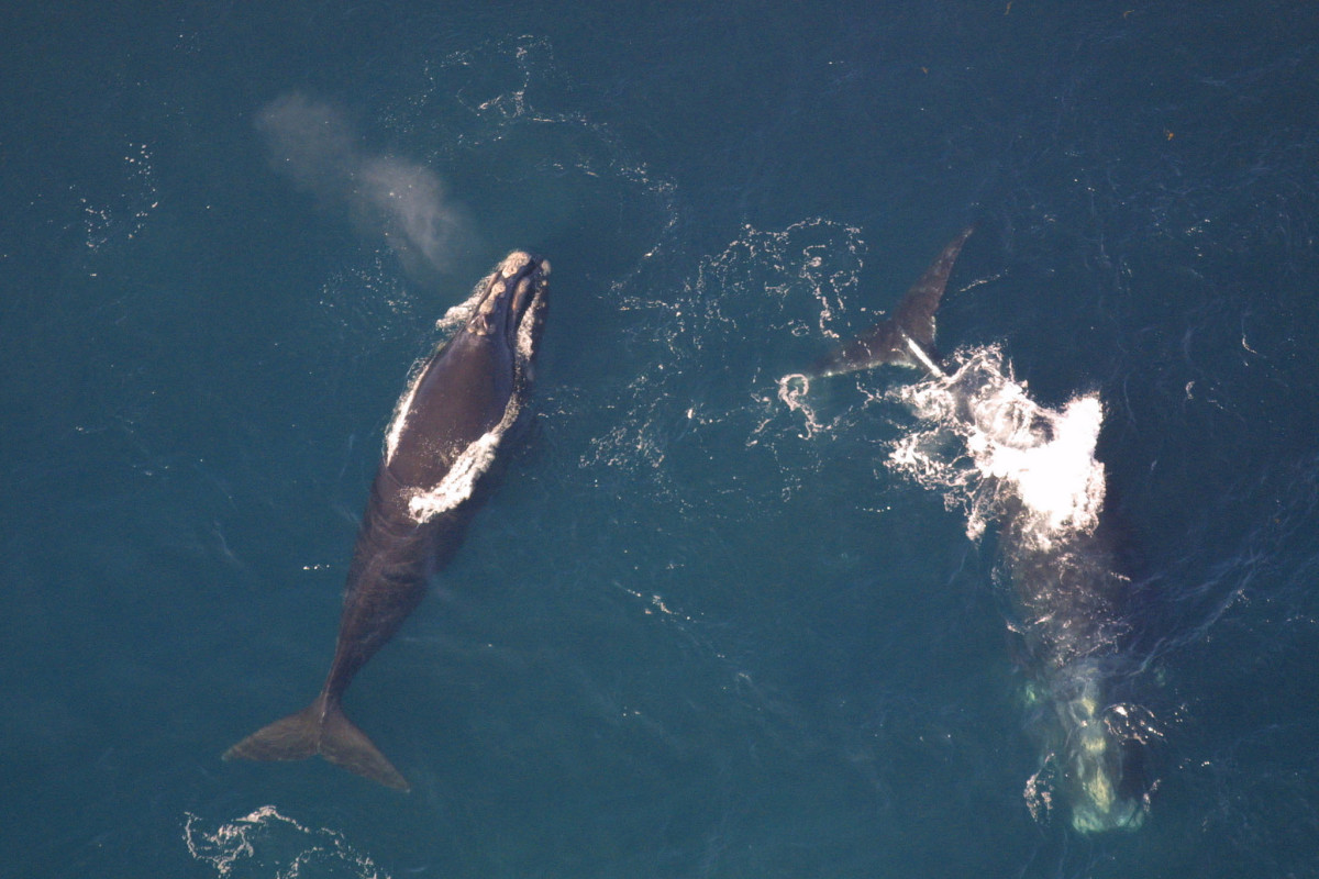
The Laurentian Channel was announced as an “area of interest” in 2010. There are plenty of good reasons for the designation: the World Wildlife Fund describes the area as a summer feeding area for humpback and minke whales, as well as endangered blue and North Atlantic right whales.
The Department of Fisheries and Oceans notes on its website that the area serves as home for porbeagle shark, smooth skate and corals. It has the highest concentration of sea pens — a soft coral — off Canada’s eastern coast.

Porbeagle shark. © naturepl.com /Doug Perrine / Courtesy World Wildlife Fund Canada
The Laurentian Channel also has the highest concentration of black dogfish in the country’s ocean territory, serving as the shark’s only pupping area in Canada and two species at risk — the Northern wolffish and leatherback sea turtle — are found in the area. To top it all off, the channel serves as feeding area for many migratory whale species including humpback and blue whales.
But there are also potential offshore oil and gas opportunities.
One reason provided by the federal government for not prohibiting exploration and drilling in the Marine Protected Area was because the reservoirs have low potential due to depressed prices and the level of front-end capital investment required.
Husky Oil had an exploration lease within the area, but it expired in 2014. Seismic and other geophysical surveys used to locate oil and gas reserves have also occurred.
However, a vice-president of the Canadian Association of Petroleum Producers recently told the Globe & Mail that “we think that whole area still holds some promise and “it’s a gas-prone area but there are companies that think there’s the presence of oil there as well.”
In an interview with Hakai Magazine, the same vice-president said, “We felt the Laurentian Channel was a very good, balanced MPA.”
Incidentally, the Department of Fisheries and Oceans reported that “costs to the oil and gas industry are anticipated to be negligible” from the implementation of the Marine Protection Area.
One of the subject matters listed by the Canadian Association of Petroleum Producers in its federal lobbying profile is “National Marine Conservation Areas Act related to workability and practicality of policy and regulations for oil and gas activity within marine protected areas.”
Perhaps unsurprisingly, such activities could have catastrophic impacts on the local animals and ecosystem.
As noted in the draft regulations, “oil and gas activities can cause permanent harm to coral and sea pens.” The government also suggested that impacts of oil exploration and development on fish, mammals and turtles is “considered reversible” due to the fact they’re mobile and can “move away from noises and other disturbances.”
Rodolphe Devillers, geography professor at Memorial University of Newfoundland, responded in an open letter, calling the claim “embarrassing to say the least” and asking “since when is chasing species away from their core habitats and possibly from the conservation area an acceptable conservation practice?”
Devillers also pointed to a recent journal article in Nature that suggested the 220 to 250 decibel sound waves created by the seismic surveys can kill huge numbers of zooplankton — which serve as food for fish and other marine organisms — over a kilometre away. The use of seismic airguns can also have catastrophic impacts on whales, dolphins, fish and turtles.

The Laurentian Channel is an important foraging area for endangered leatherback turtles. The turtles can weigh up to 900 kilograms. Photo: dchrisoh via Flickr.
Kuehnemund of World Wildlife Fund Canada said that other impacts from oil and gas activity could include the contamination of food webs, dispersion of toxic drilling waste, noise pollution and considerably higher potential for catastrophic oil spills.
Other nearby MPAs including St. Anns Bank and the Gully banned oil and gas exploration and drilling, arguably following the federal government’s guidelines that “only activities that are determined through an ecological risk assessment to be compatible with the conservation objectives of the proposed MPA would be allowed to continue.”
The draft regulations for the Laurentian Channel currently allow for seismic activity throughout the MPA for eight months of the year, even within the core protection zone. Actual drilling activity will be permissible in a vast majority of the area, “so long as they are not likely to destroy marine habitat in the proposed MPA.”
“The basic thing is that this kind of activity doesn’t belong in any kind of protected area, let alone a marine protected area,” said Sabine Jessen, national director of the oceans program at the Canadian Parks and Wilderness Society, in an interview with DeSmog Canada.
“We don’t allow those kinds of things to happen in our terrestrial protected areas. So why are we allowing that kind of industrial use in a marine protected area?”
Industry Sways Feds to Allow Offshore #Drilling in #LaurentianChannel Marine Protected Area https://t.co/Bcwup59ADn #cdnpoli @WWFCanada
— DeSmog Canada (@DeSmogCanada) July 22, 2017
It appears the oil and gas industry has had a significant amount of influence over the decision to open up ocean territory to exploration and drilling, as well as restricting the boundaries of the actual protected area.
The draft regulation from the Department of Fisheries and Oceans was remarkably transparent on this front, noting that fossil fuel lobbyists “raised concerns with respect to limitations on potential future activities” given the original Zones 1a and 1b were “inaccessible to directional drilling.”
As a result, the federal government made “subsequent modifications” to the boundaries of the core protection zone, while acknowledging concerns from environmentalists and academics that the decision was made “exclusively on possible economic gains in the future.”
But it wasn’t just the core protection zone. The very boundaries of the Marine Protected Area itself were cut down by over 33 per cent. Devillers reported in his public letter that this change led to 43 per cent of the abundance and 48 per cent of the biomass being left outside of the MPA, compared to original plans.
He also noted the Department of Fisheries and Oceans used very outdated information on the area’s sea pen populations; recent research from 2016 indicates there is sea pen habitat throughout much of the Marine Protected Area, including in much of the Adapted Management Zone that would be open to oil and gas activities.
It’s not like these facts aren’t known by many other scientists.
Novaczek emphasized there’s been “a lot of excellent work” that’s gone into planning the MPA. The problem that she points to is the actual implementation process: while a lot of research and consultations preceded the drafting of the regulations, scientists didn’t get to review the plan before it was published.
Jessen also notes the process is somewhat stacked against conservationists.
“It’s usually one seat for conservation and then you’ve got this array of industry players who are trying to protect what they’ve been allowed to do for a long time,” she says. “We have to try to negotiate this every single time for every single marine protected area. That’s just unacceptable.”
She recommends that a set of minimum standards for acceptable and unacceptable practices in Marine Protected Areas be created to ensure that such a situation doesn’t keep happening.
Specifically, many critics are calling on the Department of Fisheries and Oceans to close the area to oil and gas activities — like it has already done for commercial fishing — and get rid of the idea to have two-tiered zoning. In addition, some are advocating for a review of how the reduction in boundaries will impact conservation goals.
“We don’t get those rewards unless we make sure we’re protecting the right areas and protecting them fully with well-planned and enforced and well-regulated MPAs,” Novaczek concluded. “There’s lots of people from researchers to fishers who see this allowance for oil and gas activity within the MPA as a significant problem.”

Get the inside scoop on The Narwhal’s environment and climate reporting by signing up for our free newsletter. On March 17, federal Conservative Leader Pierre Poilievre...
Continue reading
From True Detective to The Grizzlies, the Inuk actor is known for badass roles. She's...

Artist Alison McCreesh’s latest book documents her travels around the Arctic during her 20s. In...

I’ve watched The Narwhal doggedly report on all the issues that feel even more acutely...