


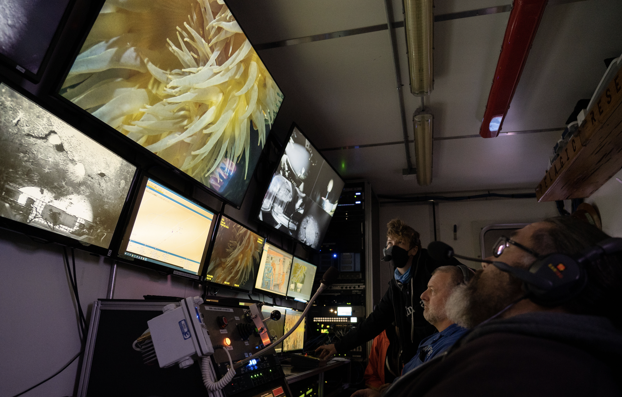
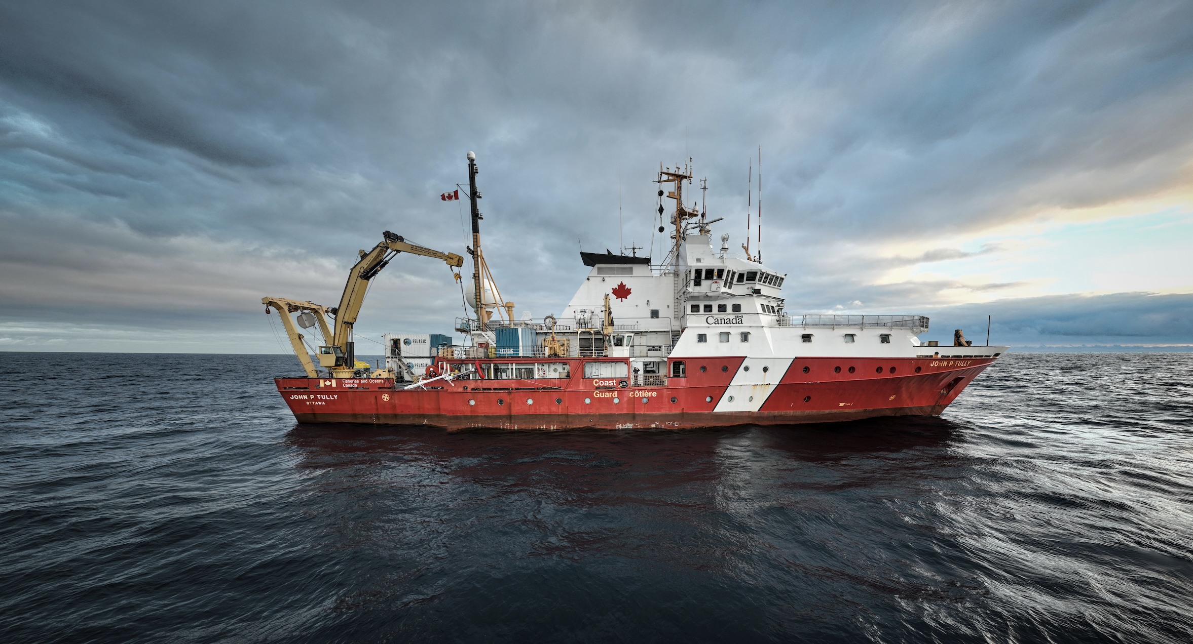
Cherisse Du Preez was staring at a monitor on the bridge of the coast guard ship John P. Tully as a single line worked its way across the screen. To her relief, the line was slowly rising, charting the shape of an underwater mountain as the sonar pings reflected off the bottom.
Then she noticed, with a twinge of regret, that not one but two lines were forming, contaminating the data she was depending on to prove the existence of the underwater mountain, known as a seamount.
“It’s going to have this error on it,” she recalled thinking, disappointed. But the line kept rising, and the regret was soon replaced with elation as the peak of the seamount appeared on the monitor, pointing up through 1,100 metres of ocean. She had discovered a new mountain. It was among a flurry of more than 45 seamounts to be discovered off the coast of Vancouver Island in a seven-year period.
“In 2016 the official number was 20 seamounts in our offshore area — for all of the Canadian Pacific,” Du Preez said. “Twenty was an impressive number. We’ve tripled it.”
It’s not typical for a biologist to make this kind of finding. “As a marine biologist I expected to discover species, not mountains,” she quipped — but a recent surge in interest in that patch off Vancouver Island has enabled discoveries of all sorts: from new animal behaviours to new species to new deep-sea ecosystems; even mountains.
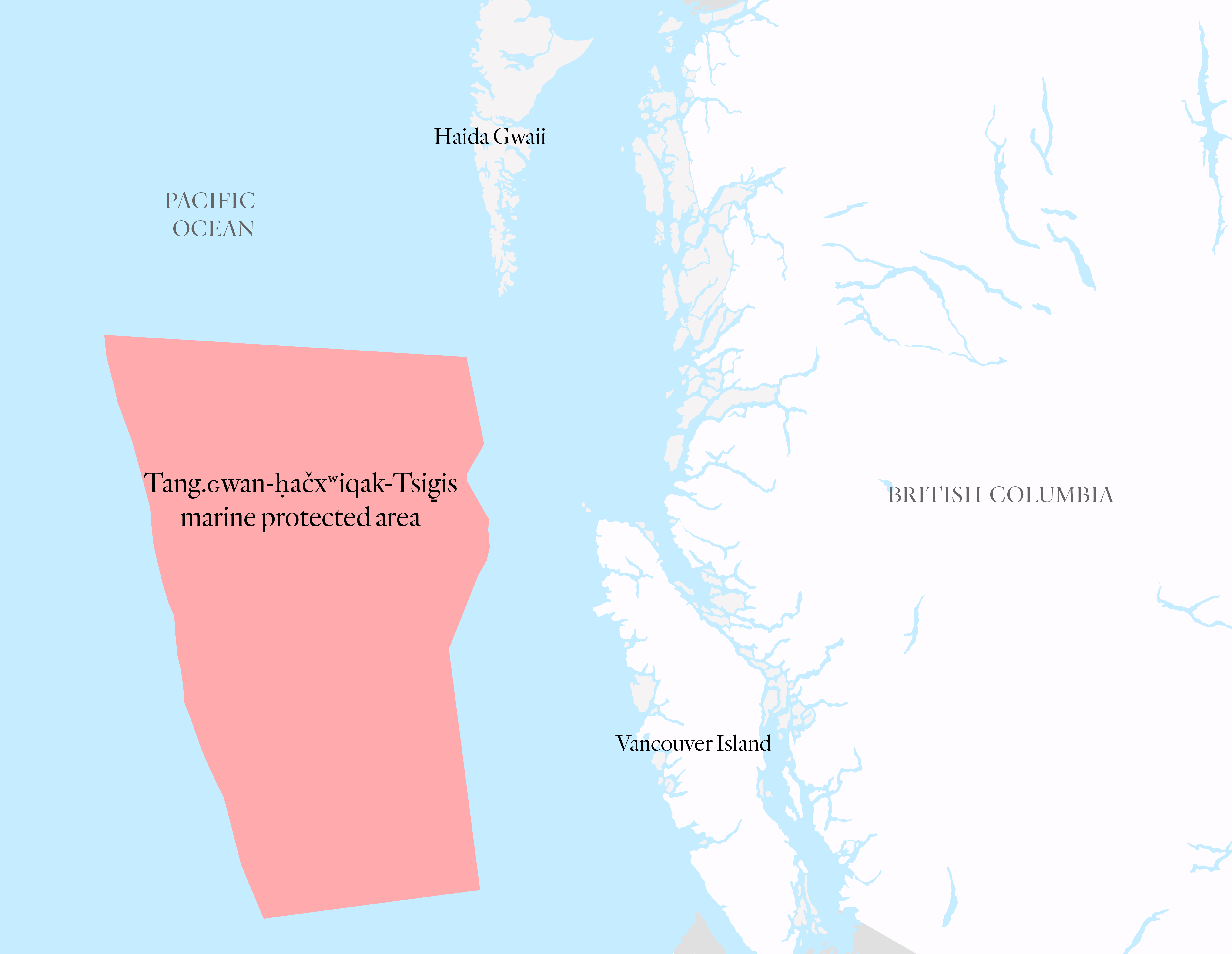
The mountains are part of an enormous, 133,000 square kilometre new marine protected area, more commonly referred to as an MPA, that’s expected to be announced at this week’s International Marine Protected Areas Congress in Vancouver. It’s located about 100 kilometres off the coast of Vancouver Island, and stretches to the western and southern edge of Canada’s ocean jurisdiction under international treaties.
It’s been in the works since before 2016, and an earlier iteration of the area would have protected an additional 6,000 square kilometres, an area larger than Prince Edward Island. (It’s not clear why that section, on the southwestern side of the protected area, was removed.) It was expected to be officially designated by 2020, but that didn’t happen.
Now, the long-awaited announcement will cement into place one of Canada’s largest protected areas — and move Canada 2.31 per cent closer to its goal of protecting a quarter of its ocean territory by 2025.
The story behind Tang.ɢwan-ḥačxʷiqak-Tsig̱is
As the scientists aboard the John P. Tully celebrated their discovery on the bow of the ship, the pickup truck-sized head of a sperm whale broke through the water’s surface nearby.
That’s when Du Preez put it together: it wasn’t an error in the data. It was a whale.
The whale’s timing seemed to the scientists like a supernatural stamp of approval for their mapping work, but their analytical side also recognized it was no accident that a sperm whale would be spotted rising along the slope of a seamount: the underwater slopes are teeming with life, attracting predators like sharks and whales.
The seamounts Du Preez and her colleagues have been charting had heretofore remained completely unknown except to some commercial fishers, who have shrewdly identified them as rich fishing grounds for the same reason the whales were there. The waters have also been used since time immemorial by First Nations for whale hunting and, more recently, their own commercial fishing.
The Tang.ɢwan-ḥačxʷiqak-Tsig̱is marine protected area got its name (which refers to “underwater mountains” and a “sea monster” in a blend of different First Nations’ languages) upon the signing of an agreement of principle with the Haida, Quatsino and Nuu-chah-nulth nations in 2022. The three First Nations will take part in the management of the area — and they’ll be naming the mountains that have been discovered there.
The Nuu-chah-nulth are taking part because “we really want to make sure that our fishing territories are managed and protected,” Judith Sayers, Nuu-chah-nulth Tribal Council president, told First Nations newspaper Ha-Shilth-Sa when the agreement was signed. “We saw it as an opportunity to do that [and] to take part in environmental protection.”
‘It’s not whether these animals are going to die, it’s, “How are they going to die?” ’
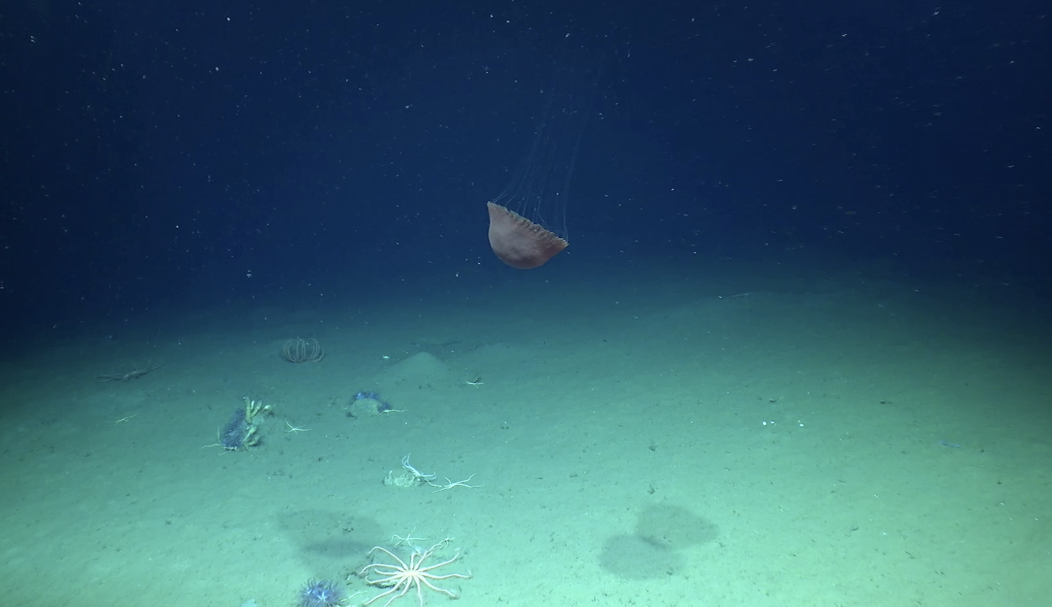
There are three unique, otherworldly ecosystems in the area to be protected: seamounts, deep-sea hydrothermal vents and methane seeps. The first two are best described in superlatives.
“With some respects, this is the highest concentration of hydrothermal vents and the highest concentration of seamounts on the planet,” Du Preez said.
Methane seeps are what they sound like: places where methane gas bubbles up from the ocean floor. The methane itself feeds unique creatures that chemically process the methane as sustenance, and in turn, those creatures feed others.
But methane seeps, also prized among scientists for the habitat they create, form rocks in places that would otherwise just be a muddy sea floor. Like a bustling intersection of country roads that creates a small community, rocks in a flat plain are valuable habitat for invertebrates and fish alike.
The actual presence of methane seeps hasn’t yet been confirmed, but Du Preez says there’s “really strong evidence” that the protected area includes an enormous one.
“If we can check that out and confirm, it just heightens the value of this MPA,” she said. That confirmation might come this summer when the researchers are returning to the site for further study.
They’ll also be returning to study the seamounts, the most obvious feature in the protected area.
The underwater mountain ranges contained within Tang.ɢwan-ḥačxʷiqak-Tsig̱is create chains of rare, special and vulnerable habitats in an otherwise featureless, muddy ocean floor.
“What you end up with is this submarine island oasis,” Du Preez said. The mountains give tiny floating larval creatures a place to anchor; they also provide hiding places for fish and scratching posts for whales and sharks. The slope itself acts as a ramp for currents, forcing nutrient-rich waters upwards and feeding shallower ecosystems, so fish and seabirds congregate higher up in the water too.
That richness puts them in harm’s way for fishing, both bottom-contact trawling and fishing off the bottom. Everywhere Du Preez has looked there, she’s found abandoned fishing gear — up to 400,000 pieces of fishing gear on a single seamount, she estimates.
The other threats come in part as a byproduct of their geography, combined with climate change.
Consider a mountain’s slope: at its lower reaches, the trees are big, broad and tall. Further up the mountain, they dwindle until they disappear, leaving behind the scrubby alpine vegetation and lichens. For a seamount, the details are different but the forces work the same: like the changing conditions as you climb a mountain, the water takes on different properties from the top of a seamount to the bottom.

Those properties are changing, with oxygen depleting at a fast clip; a paper Du Preez co-published in 2020 found there’s 15 per cent less oxygen in the water at some depths since the 1960s. It’s also acidifying. Some creatures, like fish, may be able to move to other habitats to compensate, until they reach the peak of the seamount and run out of places to go. Others, like corals and sponges, anchored to the bottom and growing and reproducing over hundreds or thousands of years, are stuck with life — or more likely, death — in the fast-changing conditions.
“Four thousand year-old coral doesn’t adapt very quick. You just lose those animals, because they don’t get to move,” Du Preez said. “The punchline of the paper is the most depressing sentence I’ve ever written: It’s not whether these animals are going to die, it’s, ‘How are they going to die?’ ”
Marine protected area threatened by deep-sea mining
Deep-sea hydrothermal vents are the charismatic stars of Tang.ɢwan-ḥačxʷiqak-Tsig̱is, concentrated in one small area that’s already protected, in the middle of its southern half.
That 97 square kilometre area, the Endeavour Hydrothermal Vents marine protected area, was Canada’s first marine protected area, and falls entirely within the new one. It protects a handful of gargantuan structures with names like Salty Dawg and Sasquatch, strung out along 20 kilometres of a ridge, 2250 metres below the ocean’s surface. But there are many more spread out among the area to be protected — Magic Mountain, Explorer Deep, Not Dead Yet — amounting to 35 known vents described in a Fisheries and Oceans Canada report, though Du Preez says it’s likely there are more yet to be found given how hard they are to find.
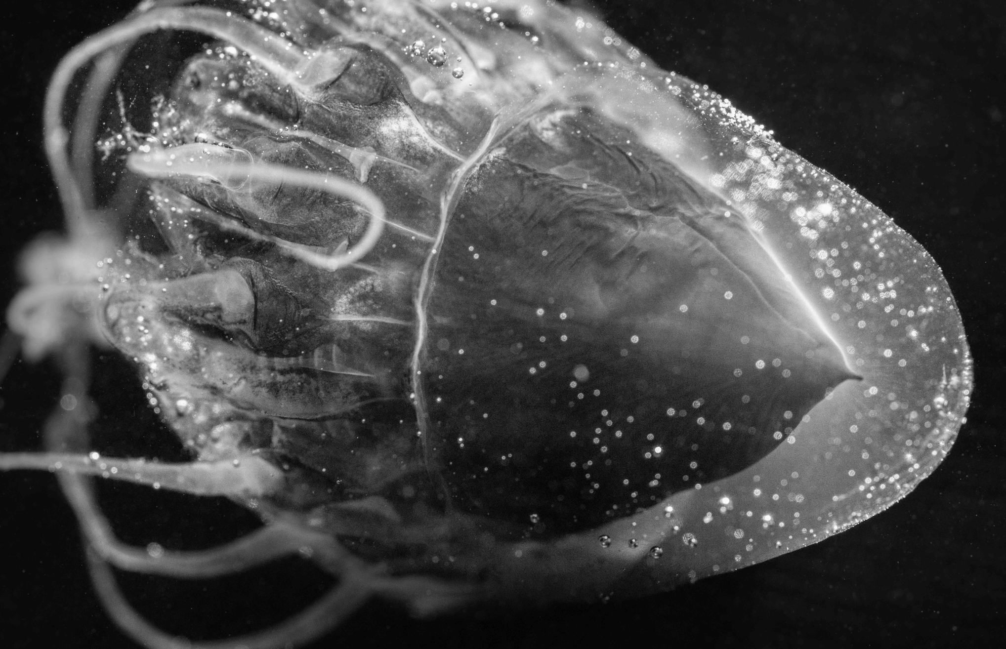
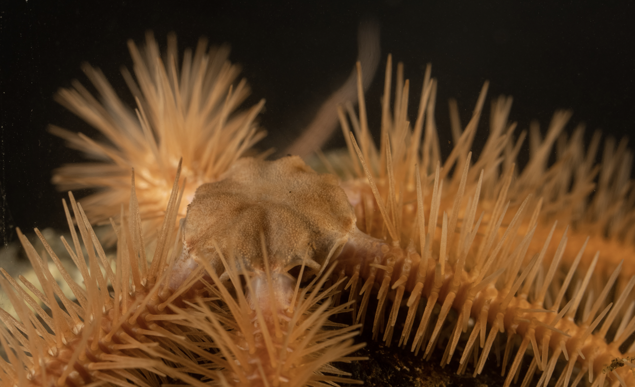
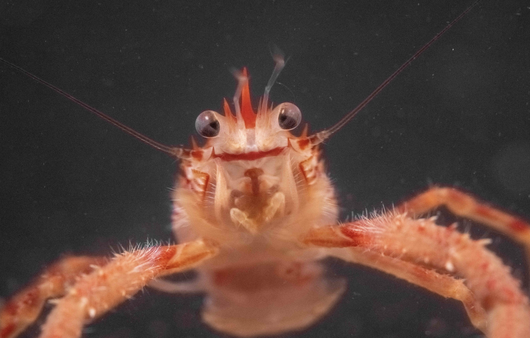
The vents are a marvel of nature, nurturing life far beyond the sun’s reach in a rare violation to the rule that the sun is the Earth’s ultimate life-giver. Towering spires of mineral deposits spewing superheated water and gases and lousy with alien lifeforms: squat lobsters, dazzling red-feathered tubeworms, giant clams with no functional digestive system that instead use symbiotic hydrogen sulphide-eating bacteria, semi-blind fish that walk around on “tripods” and shrimps that dart in and out of the water in what Du Preez has called a “dance with death” to gather food at the risk of being boiled alive.
A list of creatures seen at the vents repeatedly reverts to “species unknown,” and many of those that are known have only ever been found there. They also occur in incredible densities: a plot the size of a child’s school desk could hold half a million animals.
The landscape was “mind-blowing,” Kim Juniper, one of the leaders in hot vent science, told me in 2019 when I first reported on an earlier phase of Tang.ɢwan-ḥačxʷiqak-Tsig̱is. “Nothing had ever been seen like that anywhere in the world.”

The good news for hydrothermal vents is that they’re stable: they’re below the part of the ocean that’s losing oxygen; they’re below the part of the ocean that’s becoming more acidic and they aren’t being bowled over and scraped bare by trawlers. All they need is the absence of deliberate harm.
“Hydrothermal vents are so deep, and they’re removed from our world in that they don’t rely on it for food, so if you leave them alone, they’re kind of fine — which is great,” Du Preez said.
But we’re not leaving them alone — not everywhere.
Deep-sea mining could be about to blow up worldwide, with a deadline expiring in June for the United Nations’ International Seabed Authority to come up with rules that would allow the practice.
“There are also seamounts literally 10 kilometres off our MPA that are technically in the high seas that have been slated for investigation for deep-sea mining,” Du Preez said.
Deep-sea mining is simultaneously high- and low-tech, using complex submersibles to strip the seafloor bare in search of valuable clusters of minerals like cobalt and rare earth minerals, and crushing everything they come across: living, dead and mineral alike. Doing so produces huge clouds of fine sediment — sediment that can contain radioactive materials and choke anything it comes into contact with.
“If deep-sea mining — or when — deep-sea mining happens, the plumes will be on the order of hundreds of kilometres squared, Du Preez said.
Everything at the mining site will die. But anything nearby — or wherever the sediment drifts — will also likely die.
“That plume is also predicted for 100 per cent mortality for anything that swims through it,” she said.
That’s outside of the protected area. Inside, there will be restrictions that could prevent direct impacts.
“Canada and the co-managing First Nations are about to protect hydrothermal vents and seamounts within their control, while the rest of the world is looking to exploit hydrothermal vents and seamounts in a way that … we’ve never done before,” Du Preez said.
The precise list of what will be prohibited in the marine protected area hasn’t been set in stone yet. Kate MacMillan, ocean conservation manager for the Canadian Parks and Wilderness Society, hopes the government will be sticking to minimum standards established in 2019: no dumping, no seafloor mining, no oil and gas activities and no bottom-contact fishing.
Some fishing will likely still be allowed. Hundreds of ships fish for tuna within the protected area’s borders, and that isn’t set to change; the fishery doesn’t directly harm the bottom-dwelling ecosystems. The fishery represents a fifth of Canada’s tuna catch. Likewise, even more intensive forms of fishing (so long as it doesn’t touch the bottom) could be allowed to persist: midwater trawling, which deploys immense nets to scoop up anything in its path, will likely be allowed outside of two prohibited areas, while hook-and-line fishing for species like sablefish, halibut, and rockfish will likely be allowed everywhere.
The precise definition of dumping, however, isn’t well defined; likewise, the government says that in some protected areas, for now, bottom trawling may still be allowed and those will still count toward protection targets.
The fear from conservationists is that despite the protected area’s enormous size, it could end up as a “paper park,” protecting a lot on paper but nothing in practice.
“It comes back to the fact that if [MPAs] aren’t being implemented in the way they were set out to — to meet these conservation goals — it proves them useless,” MacMillan said.
But Du Preez is celebrating the win — and looking forward to another season watching the screens on the John P. Tully.
“It, hopefully, will be a year of discovery.”