


Picture downtown Toronto. All the condos, subways, roads, office towers and people. Now cover the whole thing with a toxic lake. Maybe you’ve never been there. Have you done the drive from Calgary into the Rockies? Imagine almost the entire 105-kilometre stretch from the city to Canmore as one continuous vista of oilsands tailing ponds.
According to a new report from Environmental Defence and the Canadian Parks and Wilderness Society, those are just two examples of how large the tailings ponds in northern Alberta have grown.
And despite new rules introduced in 2016 around managing tailings, the ponds have continued to grow, according to the report. This growth represents an increasing ecological and economic risk that will cost billions of dollars to clean up and could leave taxpayers footing the bill.
So what exactly does that look like on the ground? And what impact do tailings ponds have?
Here’s a bit of background.
What are tailings ponds?
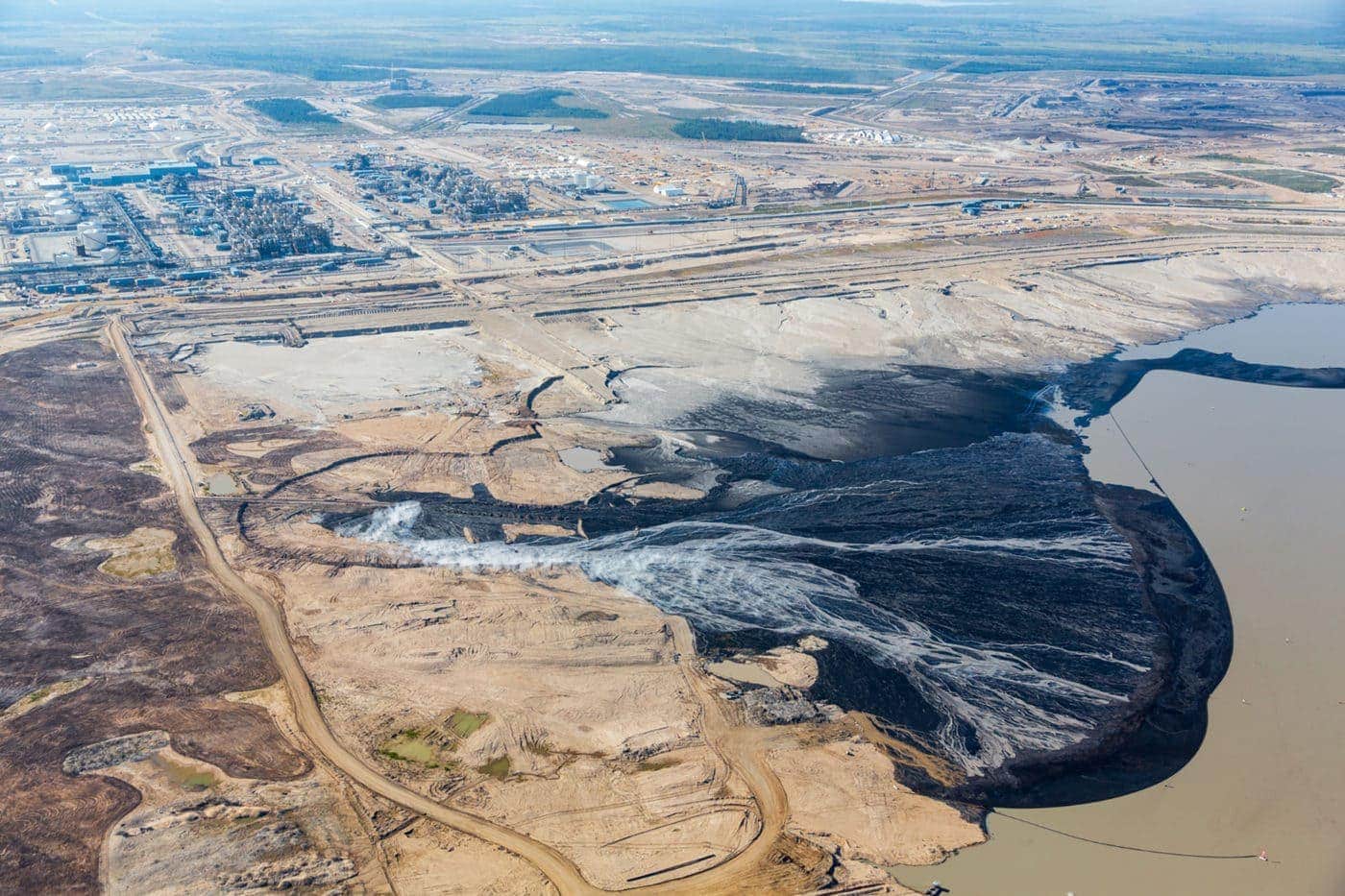
First thing to note, and it’s something the authors of the report stress right off the top: the ponds are anything but ponds as most people understand them.
“To be calling them ponds when tailings ponds actually are far larger than anything you would ever describe as a natural pond — it’s deception,” Gillian Chow-Fraser, co-author of the report and boreal program manager for the Canadian Parks and Wilderness Society, says.
“I don’t think it’s being very accountable to the level of destruction that’s happening in northern Alberta.”
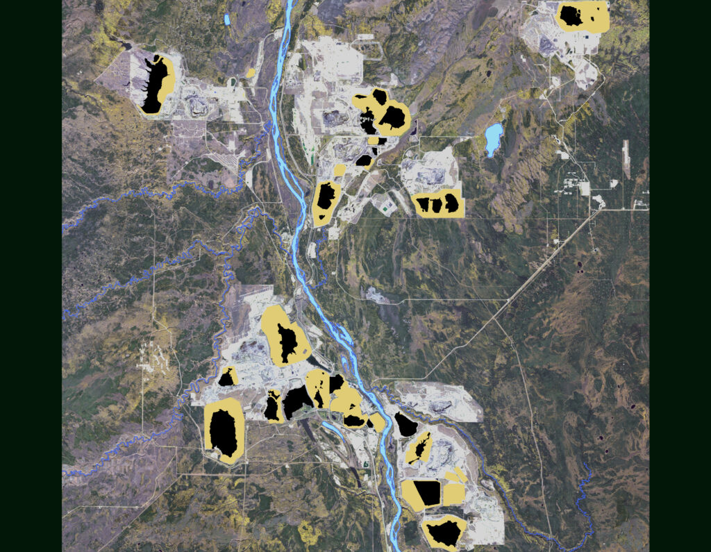
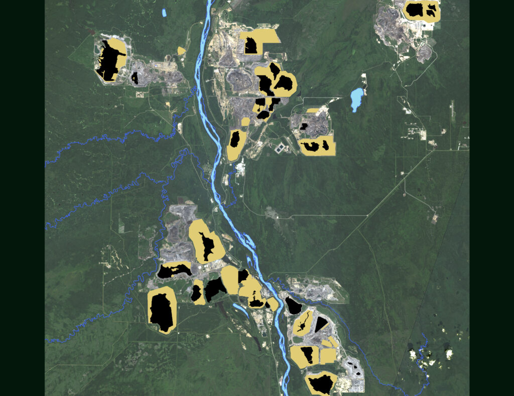
One of the largest ponds, notes Chow-Fraser, is eight kilometres long. That’s almost as long as Alberta’s famed Sylvan Lake. Looking further afield, that will almost get you to the top of Mount Everest.
That said, the report uses the term to maintain consistency while expounding on the decidedly un-pond-like size of the waste reservoirs.
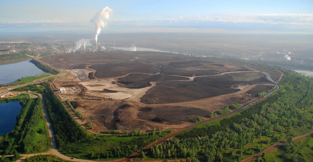
Inside those ponds is a toxic mix of byproducts from the mining of oilsands, including arsenic, naphthenic acids, mercury, lead and polycyclic aromatic hydrocarbons — all of which can impact ecosystems, wildlife and humans.
The ponds also emit air pollution that extends for kilometres.
The purpose of the ponds is to allow the byproducts of mining to separate from the water and settle at the bottom of the pond, a process that can take decades or more. Once those byproducts are settled, the pond can be drained and capped with soil to achieve some level of reclamation.
Why are Alberta oilsands tailings ponds still growing?
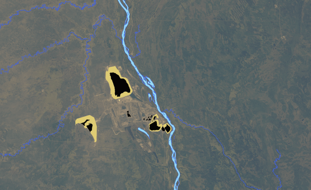
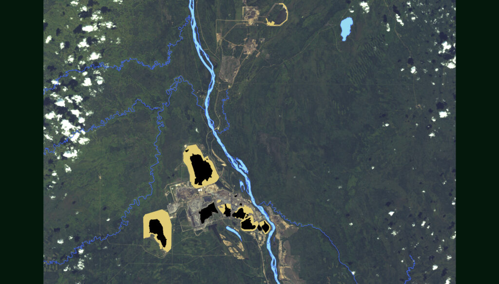
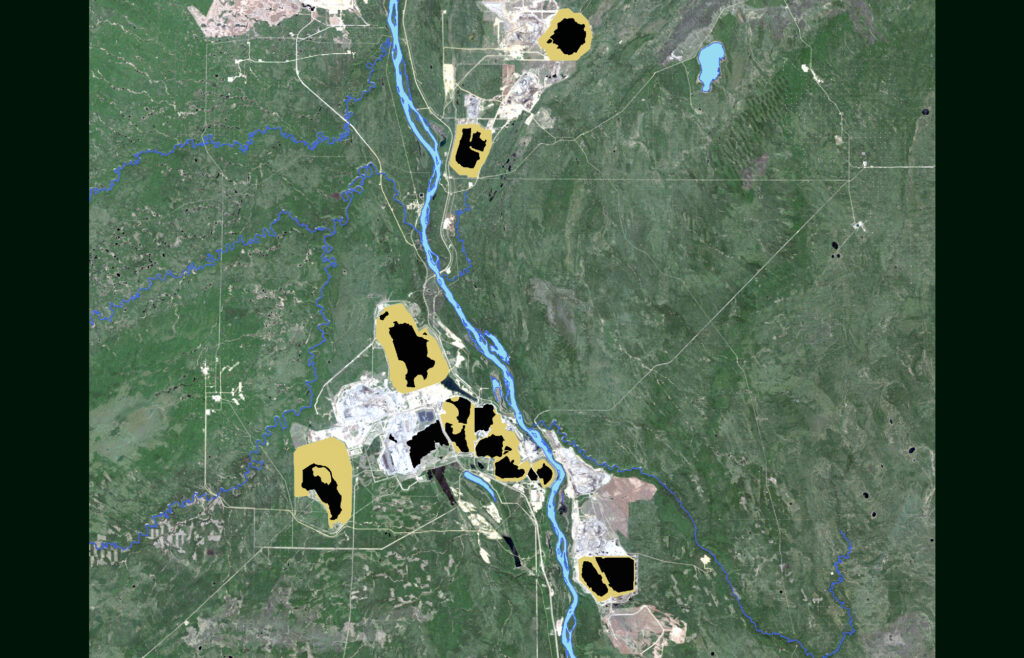
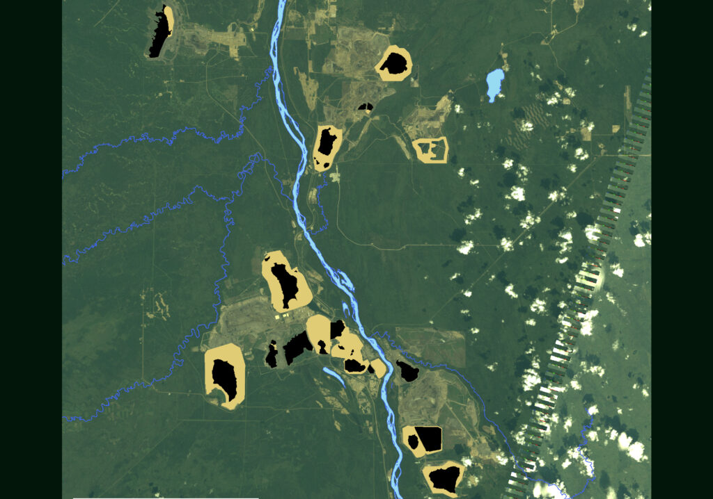
The tailings ponds have been growing for nearly 50 years, increasing in size by nearly 800 per cent in the late 1970s, before continuing to grow at varying rates, depending on factors such as global demand for oil and the state of the economy. Most recently, the size of the tailings ponds grew by over 50 per cent from 2010 to 2015, and then by just over 16 per cent from 2015 to 2020, according to the report.
There are now 30 active ponds in the region, the report also says.
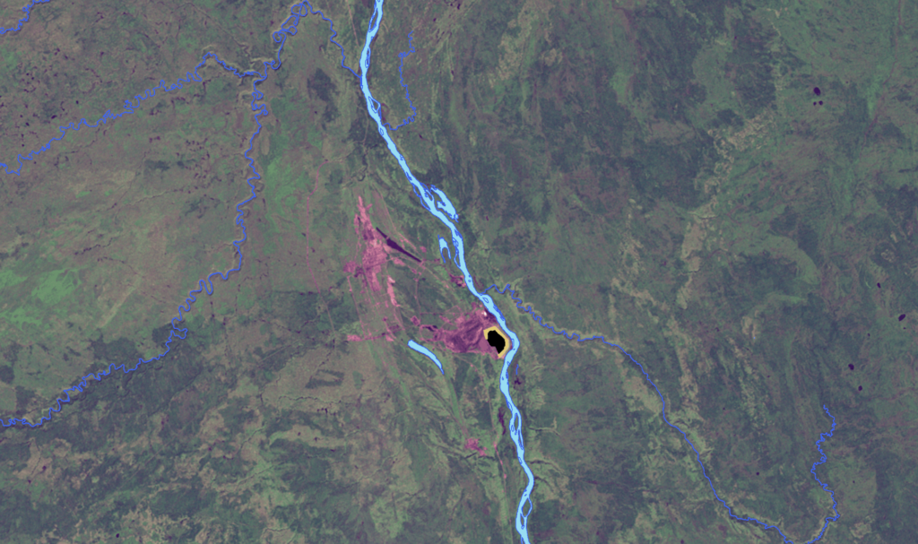
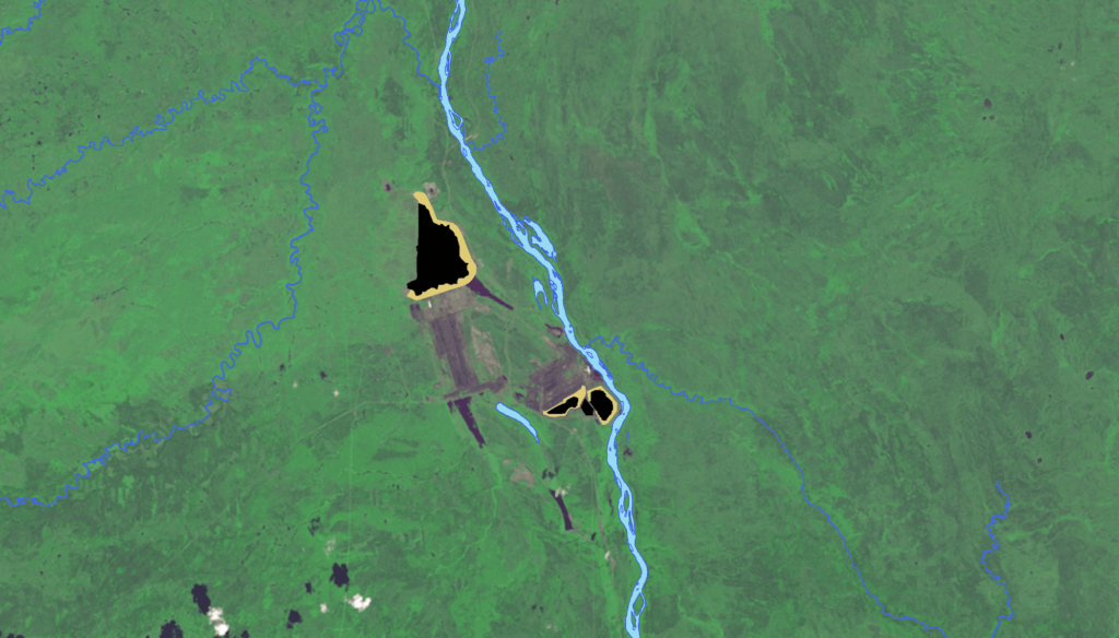
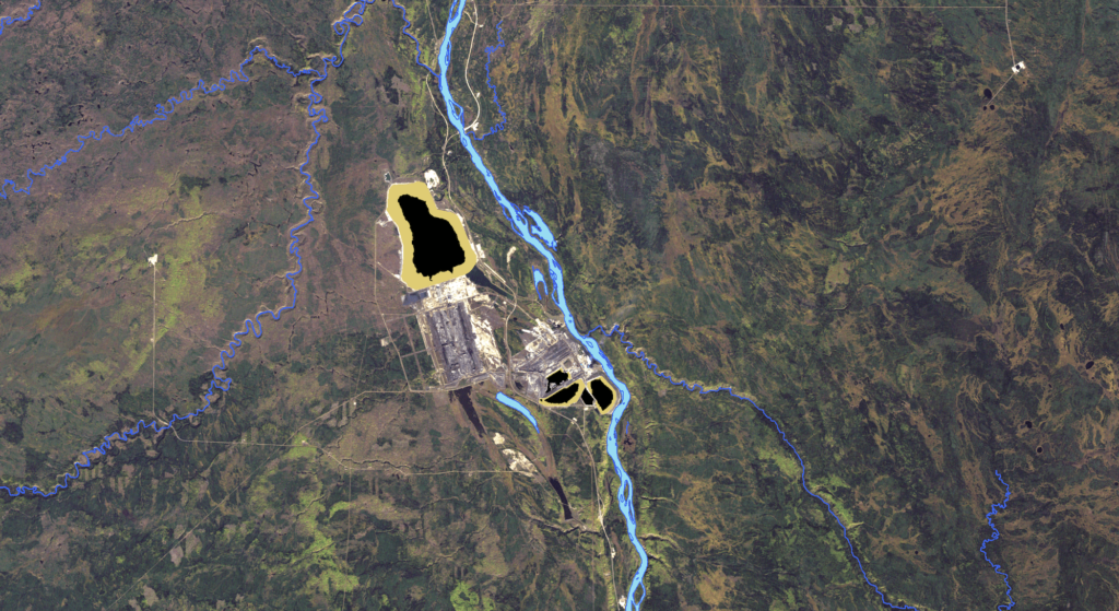
The authors used satellite imagery going back to 1975 to measure the physical growth of the ponds — including the fluids and the related impacts such as berms and areas where dry tailings are stored — but not the volume of tailings they hold.
For that they relied on Alberta Energy Regulator reports (more on that shortly).
Aliénor Rougeot, co-author and climate and energy program manager for Environmental Defence, says they included things like berms and beaches created by the ponds — where you would not want to sunbathe — because all of it impacts the surrounding area.
“That’s the peatlands and boreal forest that were taken away, or that’s the area that the Indigenous communities can no longer have traditional practices on,” she says.
In total, the report says the footprint is 300 square kilometres, big enough to more than twice cover the city of Vancouver or a large chunk of Toronto.
“I live in downtown Toronto, and so I think I know what large means, I think I know what human activity taking over nature looks like,” Rougeot says.
“And yet when I saw the scale when I saw those maps, especially the layovers of cities. I mean, that was just baffling to me.”

Ponds increase as new expansions or new mines are approved and the existing ponds fail to shrink.
The report did not trace the rise in the volume of the ponds, but that has also increased over the years, and the report notes current levels are 1.4 trillion litres of tailings based on Alberta Energy Regulator figures.
Wait, doesn’t the Alberta government have stats on the growth of oilsands tailings ponds?
Well, yes and no.
The report sprang from the lack of public information on the physical presence of the ponds on the landscape. There is no easily accessible data on the size of the ponds and just how much of the boreal landscape they have eaten up.
There is no place to compare previous years and see how much or how quickly the area of the ponds have expanded.
Beginning in 2018, there is information on the amount of fluid being held by the ponds across the oilsands.
The Alberta Energy Regulator notes the 1.4 trillion litres in 2020 is an increase from 1.1 trillion litres in 2014, but the report with those figures is based on information self-reported by industry. It’s also incomplete, according to the regulator, due to suspended reporting and monitoring requirements it introduced during the pandemic.
The figures could change when an updated report into tailings management is released in October.
The latest figures also do not take into account tailings that companies have told the regulator are “ready to reclaim” — a change from past years of reporting.
Also of note, tailings volumes increased in 2020 despite a reduction in bitumen production in the mines.
The Alberta Energy Regulator has not yet responded to emailed questions from The Narwhal. The office of Environment Minister Jason Nixon also did not respond to emailed questions.
So what is being done to manage toxic tailings ponds in Alberta’s oilsands?
Until 2009 there were no regulations and cleanup was “essentially voluntary,” according to a history of regulations from the Pembina Institute.
That was followed by regulations, which lasted for four years, that called for companies to clean up 50 per cent of new tailings by 2013, which fell apart shortly after being introduced when the regulator started accepting applications that did not comply with the standard.
“Soon after, the regulator quietly released its annual tailings management reports, revealing that every single company had failed to meet both the standards … and the weaker targets they had individually negotiated with the regulator,” according to the Pembina Institute.
That regulatory regime changed in 2016 with the introduction of a new tailings management framework, which looks more at cumulative impacts and is more flexible. It allows companies to determine their own processes for dealing with tailings based on individual reclamation plans.
Canada’s Oil Sands Innovation Alliance, an industry group focused on improved environmental performance, says the ponds provide “critical storage to reuse and recycle most of the water used in oilsands processing,” and the regulations in place to manage them are stringent.
“Because regulations for treating and releasing water used in oilsands processing do not yet exist, the volumes of water in these ponds have increased over time and include significant amounts of precipitation that has fallen since the beginning of operations in the 1960s,” reads one part of a statement emailed to The Narwhal attributed to the alliance’s chief executive, Wes Jickling.
The release of water from oilsands tailings ponds into the Athabasca River is one option that is currently being considered by the federal government, which is responsible for protecting fish habitat — something opposed by the Northwest Territories which is downstream, and First Nations communities.
“When you look back over the past 45 years, they don’t have any evidence that they can really tackle this problem on their own,” Chow-Fraser says of industry.
“They fail to demonstrate any ability to reduce the tailings ponds and they’re just growing and getting bigger.”
Only 0.1 per cent of the lands impacted by oilsands operations have been certified as reclaimed at this time. That amounts to just over 100 hectares, and the regulator says there is an additional 8,700 hectares that have been reclaimed but not yet certified.
The Alberta Energy Regulator told The Narwhal that no tailings deposits have yet been certified as reclaimed.
As of 2021, the regulator said every company “had fluid tailings volumes on approved growth trajectories.”
According to the regulator, the estimated liabilities for cleanup of the oilsands is $33 billion. Only $1.5 billion has been collected for security as of June 2021.
Is a reclaimed tailings pond ever really reclaimed?
Sort of.
The individual company and the regulator will develop a plan for closure and reclamation of a mine, but each one will be unique.
The overall rule is that a mine site has to be returned to an “equivalent land capability,” but that doesn’t mean it will be like it was before. Peatland, a key carbon sink and abundant in the area, cannot be recreated, for example.
“It seems really out of touch to what reclamation should be. It should have higher standards than filling a pond and planting grass on top of it,” Chow-Fraser says.
“It should be about supporting Indigenous traditional practices, and so you need to have that land that’s returned to one that can actually be a healthy boreal ecosystem, and that’s used by wildlife, but that is also usable and accessible by Indigenous people.”
The report authors relied on knowledge from Jean L’Hommecourt, a Denesuline woman who lives just out of Fort McKay near the oilsands and Mike Mercredi, a Denesuline man from Fort Chipewyan to the north.
Both have seen the impacts of oilsands development on their communities and traditional ways of living.
The sheer size of the ponds speaks to the impact on the surrounding land, but that doesn’t take into account the mines themselves and the far-reaching impact of toxins leaking from the ponds into waterways and groundwater, or the air pollutants they emit.
The report contrasts the large scale of the ponds with the impacts they have at a human level.
Speaking by phone, L’Hommecourt says she and others in her community have simply gotten used to the constant smell of the tailings, the stinging eyes and burning throats. Her community, Fort McKay, is essentially surrounded by the ponds.
“It’s indescribable, I guess, because it smells like gases, it smells like chemicals,” she says.
“When you breathe it in, it kind of permeates through your nose and you can even have that taste in your mouth.”
The fish isn’t good to eat and the water isn’t good to drink, she says. She worries about the impact on moose who graze by the river’s edge and how they might pass along any contaminants when they’re eaten.
“L’Hommecourt points out, you know, if it’s reclaimed but it’s in between two toxic pits, I’m not gonna bring my grandchildren and so it’s not reclaimed,” Rougeot says.
How do tailings ponds impact nearby Indigenous communities?
Elders have to travel far to conduct land-based teaching, according to L’Hommecourt. Everything from harvesting to fishing to traplines are affected. The traditional territories have been leased and ripped up and made inaccessible.
“To go somewhere, you have to deal with gates, you have to deal with security, you have to deal with no trespassing signs, and everything of that sort,” L’Hommecourt says.
“We’re being dictated to as to how we should live our way of life.”
L’Hommecourt says First Nations were not consulted when the oilsands were first developed and it’s only recently, now that the damage is done, that companies come calling.
“There are regulations there, but they’re too soft,” she says.
“Those lands around us, they’re the money making lands. All our resources are being shipped to the States and China and we’re the ones suffering for that. To support everybody to have whatever they want, I guess.”