


In a report released Wednesday, the Canadian Parks and Wilderness Society’s (CPAWS) Yukon chapter calls out the Yukon Environment and Socio-economic Assessment Board for approving road projects linked to natural resource extraction before land use plans are completed.
The report, called Eroding the Yukon’s Wild Character, argues that roads and the full weight of their impacts aren’t being adequately accounted for by the assessment board.
New roads have ecological footprints that extend far beyond the narrow strip of space they take up. More roads beget more human activity, such as hunting and mining, in otherwise undisturbed places; migratory patterns of animals can take a hit, too, the report says.
Land use plans take a broader look at how a region should be managed and monitored and the planning process is better suited to determine the potential impacts of roads and inform the assessment board’s decisions regarding the fate of untouched regions — of which Yukon still boasts many, the report says.
“Land use planning can take that broader view of how much development is allowable in an area, which areas should we keep remote and free of roads,” Malkolm Boothroyd, the report’s author and campaigns co-ordinator at the Yukon chapter of CPAWS, tells The Narwhal.
“I think we’re hoping that Yukoners will talk about it and figure out how many roads there should be in this territory and what areas we want to keep road-free,” he continues.
“I think what’s very special about the Yukon is that there are still areas that you can’t drive to. That’s incredible habitat for caribou and grizzly bears and that’s really rare in this day and age.”

A porcupine climbs over a concrete safety barrier on the outskirts of Whitehorse. Photo: Malkolm Boothroyd
‘Once that first cut goes into the watershed, waves of development could follow’
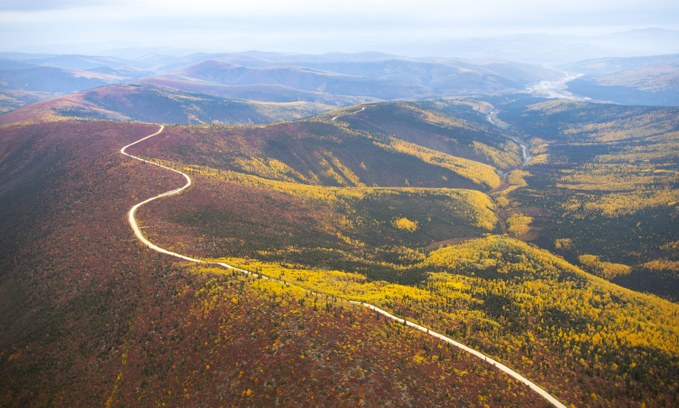
There are two large road projects on the docket in Yukon right now — the Resource Gateway and ATAC Resources road projects.
The former is a massive undertaking, worth a projected $470 million, that will build and revamp 650 kilometres of road into the mineral-rich Dawson and Nahanni ranges.
“Major resource road projects like the Yukon Resource Gateway Project would amount to de facto land use planning: irreversibly changing whole regions before land use plans can be completed,” the Canadian Parks and Wilderness Society of Yukon report says.
Roads would feed into proposed Dawson-area mine sites such as the Coffee Gold project, which if built could be the largest gold mine in Yukon, and the Casino proposal, which is so large it spurred a panel review by the assessment board — the most rigorous approval process the territory has to offer.
Road construction and the probable increase in mining activity in the area would have “serious consequences” for the Klaza caribou herd, the report says.
“Roads would bisect the valley-bottom habitats caribou depend on during winters, and significantly increase year-round human activity in the herd’s range,” it says. “Further road construction and development of Casino and other mines could force caribou out from high value winter habitats in the northern part of their range.”
Industrial development that follows the road’s construction could also impact the Fortymile caribou herd’s historical summer range, the report continues.
Having a land use plan in place before certain projects occur could mitigate impacts like these, as they could identify sensitive areas into which roads should not encroach.
The federal government is bankrolling the lion’s share of the Resource Gateway project at roughly $250 million, with the Yukon government and mining industry covering the rest. This muddies impartiality required during the assessment process, the report says, because the Yukon government also has the power to accept or reject recommendations provided by the assessment board.
A spokesperson with the Yukon government’s Department of Energy, Mines and Resources tells The Narwhal that development in Yukon needs to be accommodated while land use planning is underway in other parts of the territory.
“The Government of Yukon recognizes the importance of land use planning to guide future development and is actively engaged in a number of collaborative land use planning processes with Yukon First Nations, communities and stakeholders.”
Currently, the Yukon government is in the process of consulting affected First Nations along the Resource Gateway route. The territory has struck agreements with three First Nations to build or upgrade roads and bridges within their territory, along that route. According to the territorial government, the project will be completed by 2024.

The Resources Gateway and ATAC routes are major road projects in the works in Yukon. Map: Carol Linnitt / The Narwhal
The ATAC road, on the other hand, was approved by the assessment board in 2017. The Vancouver-based exploration company wants to run a 65-kilometre road through the Beaver River Watershed, northeast of Mayo. But there are some outstanding problems with the project. The company has a swath of mineral claims beyond the end of the proposed road, spurring a sub-regional land-use plan by the Yukon government and the First Nation of Na-cho Nyak Dun. According to the CPAWS report, it was decided that the avalanche of development the ATAC road could trigger was beyond the scope of what the assessment board considered in its review.
So before the road can go ahead, the land use plan has to be completed.
Had land use planning come first, Boothroyd says there would have been more opportunities for Yukoners to weigh in on the region’s future. But, as it stands, the road is being taken as an unavoidable prospect and the land use plan is a means of mitigating harm.
“Once that first cut goes into the watershed, waves of development could follow,” Boothroyd says.
The limits of Yukon’s assessment board
The Yukon Environment and Socio-economic Assessment Board focuses on site-specific impacts to water, flora and fauna, offering recommendations to the Yukon government, which then signs off on them. But the assessment body lacks the tools necessary to address the far-reaching effects of roads, according to the report. Built to provide access, roads are a vector for change far beyond their footprint.
“Like many environmental review processes, (the assessment board) was not designed to address big-picture questions, such as how roads accelerate resource extraction and transform landscapes, or how cumulative impacts affect ecosystems and communities,” it says.
Further, road projects tend to be screened by designated offices, which, according to the report, are branches of the assessment body that conduct lower-level reviews. Six district offices in Yukon handle the majority of assessments that go through the board. One of them handled the ATAC road project.
“Designated offices take an average of 82 business days to review projects, while the impacts brought on by road developments would last for generations,” the report says.
In lieu of a land use plan, Boothroyd says, road proposals should be handled by the assessment board’s executive committee because their assessments tend to be more robust.
According to a report conducted by the Yukon Land Use Planning Council, which facilitated a symposium last year on the challenges of addressing cumulative effects, an official with the assessment board pointed out problems with project-level assessments, such as a lack of monitoring, data and enforcement.
“A common theme that emerged was the poor suitability of project-level assessments to address cumulative effects,” the planning council’s report says. “One of the main issues facing governments in their approach to cumulative effects is that the current approach is reactive rather than proactive.”
A spokesperson with the assessment board wasn’t available for comment.
Take a page from the Peel
The Peel Watershed Regional Land Use Plan took more than a decade to bring to fruition. The process started in 2004. Ten years later, the Yukon government of the day wanted to open up most of the area to development. First Nations and environmental organizations took the Conservative Yukon Party to the Supreme Court of Canada and, in 2017, Canada’s top court sided with First Nations.
Last summer, the land use plan was finally signed by the current Liberal Yukon government and First Nations, protecting most of the watershed — mining, roads and oil and gas projects are only allowed in one parcel, representing 17 per cent (11,573 square kilometres) of the total land mass.
It wouldn’t be a stretch to say that land use planning can be protracted. But Boothroyd says Yukoners shouldn’t wait decades for a plan to be written, not to mention until after development is imminent.
How can planning be sped up to avoid another saga like the Peel?
Land use plans could be developed concurrently in different parts of Yukon, Boothroyd says, noting more federal funding could make this a reality. For areas without regional land use plans, smaller-scale, sub-regional land use plans should be developed, akin to the one happening in the Beaver River Watershed. These types of plans zero-in on even finer details than a regional land use plan.
All of this, though, should occur before decisions are made to bisect and open up previously undisturbed lands.
“A road should not be a starting assumption,” Boothroyd says.