


Summary
- Climate change is making extreme weather events, like rain-heavy atmospheric rivers, more frequent and more intense.
- Human activities — like developing wetlands and logging — have also increased flood risks in many parts of B.C.
- The B.C. government has yet to fund the implementation of a flood strategy developed in 2024.
- As extreme weather events like atmospheric rivers happen more often, investing in flood mitigation and resilience measures can help reduce their impacts.
We’re trying out staff-written summaries. Did you find this useful?
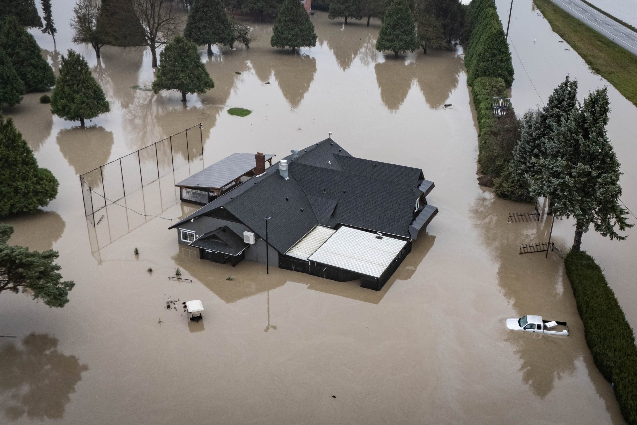
This week, atmospheric rivers are expected to dump as much as 250 millimetres of rain on parts of B.C.’s coast. The deluge has prompted flood watch and high streamflow advisories across the Central and South Coast as well as Vancouver Island. On March 17, an evacuation order was issued for part of the tiny community of Martin Falls, near Bella Coola.
These are some of the first flood warnings of the year, but they likely won’t be the last. Climate change is making extreme weather events, like rain-heavy atmospheric rivers, more frequent and more intense. While parts of B.C. have been dealing with drought conditions for years, the province has also experienced multiple atmospheric river events since November 2021, when a series of storms caused extensive flooding. The 2021 floods were one of the most costly weather-related disasters in B.C.’s history with billions in damage to infrastructure, homes and businesses.
In the years since, B.C. has taken some steps to improve flood resilience and preparedness across the province, including developing a province-wide flood strategy in 2024. But this year’s budget lacked funding to implement that strategy.
“The B.C. government should prioritize funding for the strategy moving forward to better protect residents in the future,” Aaron Sutherland with the Insurance Bureau of Canada said in a statement issued in December 2025, after an atmospheric river once again walloped the Lower Mainland.
“Investing in community resilience and damage prevention is always more cost-effective than paying to rebuild year after year following every disaster.”
Here’s what you need to know about flood risks and response in B.C.
What is an atmospheric river?
An atmospheric river is a band of warm, moisture-laden air many hundreds of kilometres long and hundreds of kilometres wide that borders a large cyclonic low-pressure system.
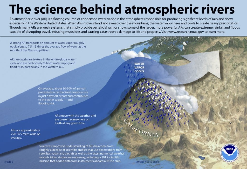
Think of it like a fire hose stretching across the sky.
Atmospheric rivers can drive record-breaking rainfall by dumping a large volume of precipitation over an extended period of time.
What’s B.C. doing — or not doing — about increased flood risk?
In the wake of the 2021 floods — which left five people and hundreds of thousands of livestock dead — the provincial government developed a new flood strategy. It committed to improve flood risk mapping, invest in new infrastructure, restore wetlands and other ecosystems to reduce flood risks and invest in community-led initiatives to relocate people from particularly risky areas.
However, the provincial government has yet to commit funding to make the strategy a reality. Meanwhile, in October 2024, another atmospheric river struck the Lower Mainland, killing five people.
“It’s a great policy, but it’s troublesome that there’s no resources to actually implement it,” Tyrone McNeil, president and Tribal Chief of the Stó:lō Tribal Council and chair of the Emergency Planning Secretariat, told The Narwhal in December.
This year’s budget, unveiled in February, did not earmark any funding for the flood strategy.
Why are flood warnings on the rise?
Broadly, there are two major reasons why floods are becoming more common.
First, climate change. Warm air can hold more moisture, so when temperatures rise, heavy rainfall events become more likely and more intense. More rain — especially in short periods of time — can result in more flooding.
Human activities are also contributing to flood risk. Decades of converting wetland areas — and even entire lakes — into farmland have reduced the capacity of local ecosystems to absorb and divert rainfall.
Logging has also taken a toll. Younes Alila, a professor of forest hydrology at the University of British Columbia, is focused on the impact of clear-cut logging on watersheds. Alila’s research in the Kettle River watershed connects extensive logging activity — two-thirds of the watershed has been harvested in the last 30 years — with severe flooding, like the devastating 2018 floods in Grand Forks that displaced more than 100 families.
“What is happening in the Kettle River basin is typical of what has been happening and will continue to happen for decades in other drainages across all of B.C.,” Alila told a crowd at the global premiere of the documentary Trouble in the Headwaters in Victoria in June 2025.
What else could be done?
Developing better modelling to understand the risks of heavy rainstorms could help identify the most at-risk flood areas, McNeil says. He also points to hundreds of kilometres of historically fish-bearing streams through the Fraser Valley and the Lower Mainland that have been cut off from the Fraser River by railways, roads and dikes. Reconnecting these waterways could mitigate flood risks.
Allowing part of Sumas Prairie — which was created when Sumas Lake, known as Semá:th Xhotsa, was drained and converted to agricultural land in 1924 — to return to being a lake could help reduce flooding risks in the Lower Mainland and support wildlife.
Similar programs to restore ecosystems across the province could also help. But as floods — as well as fires and other natural disasters linked to climate change — continue to cause damage to communities, considering where or whether to rebuild is becoming an increasingly urgent question.
Managed retreat — the planned relocation of people and buildings away from risk-prone areas — is already a reality in some parts of B.C. and in Canada. Following extensive flooding in 2018, 100 homes in Grand Forks were deemed too flood-prone to be livable. The homes were bought by the town, demolished in 2022 and replaced by infrastructure aimed at protecting neighbouring homes from the effects of future floods.
In the coming decades, more communities are likely to face tough choices about whether to rebuild after a disaster or choose managed retreat instead.