


On Friday the Energy Resources Conservation Board (ERCB), the Alberta government's industry regulator, released a report stating that tar sands companies have failed to comply with pre-existing agreements to limit the amount of water used in tar sands extraction and processing as well as the amount of polluted water that ends up in the region's growing toxic tailings ponds.
The release of the report coincides with massive floods near Fort McMurray, wreaking havoc on the city's infrastructure. Since Friday the region has seen between 80 and 180mm of precipitation. Major highways have been closed, roads have been partially washed out, buildings flooded and homes evacuated. The city of Fort McMurray officially declared a state of emergency today, while unseasonably high temperatures prompt snow melt and rain is forecast to continue throughout the week.
The immediate question is apparent: what threat does the flooding pose to the massive tailings ponds lining the Athabasca River and the millions of litres of toxic contaminants they contain?
According to recent industry figures, tailings ponds, which hold the billions of litres of contaminated waste water used in bitumen extraction and processing, cover 176 square kilometres of the tar sands region.
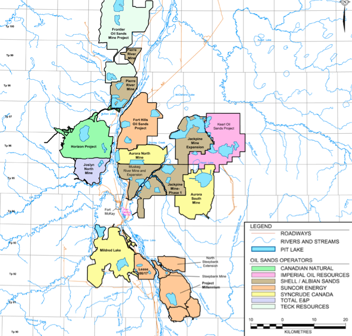
Numerous tar sands projects line the Athabasca River and tailings ponds – represented here as "pit lakes" – border the river's banks. (This project map is from the Cumulative Environment Management Association's "End Pit Lakes Guidance Document," a report that outlines an industry plan to convert the waste ponds into a recreational 'lake district.')
This morning Alberta Emergency Alert released a flood warning that announced areas adjacent to the Hangingstone River, a tributary of the Clearwater River which feeds directly into the Athabasca River, were flooded and experiencing bank erosion. The flooding has been gradually moving north toward the highly populated areas of Fort McMurray and in the direction of major tar sands developments.

The water's migration north and throughout the floodplains nearing the Athabasca River have some worried the waters may breach the various processing plants, upgrading facilities and tailings ponds throughout the region.
Jesse Cardinal from the Keepers of the Athabasca said today, "We are definitely concerned about the flooding…"
"[These] are the highest ever recorded amounts [for water levels] and Fort McMurray is on a boil water advisory…What are the downstream effects?"
A recent study released by Environment Canada states that pollution from the tar sands has affected the water in areas as far away as 100 km from Fort McMurray. Tar sands related toxins, including polycyclic aromatic hydrocarbons (PAHs), are known to be fatal to young fish during the developmental stage.
In February, internal government documents released through Access to Information legislation confirmed tailings ponds were leaking into local groundwater. Further concerns about contamination are growing with the rising river levels.
This morning Suncor Energy, a major tar sands company, announced via facebook that a road near its MacKay River in situ project had suffered damage from the heavy rains, saying employees were being advised to ration water until transport plans could be addressed. Another of Suncor's facilities, pictured below, lies on the banks of the Athabasca River, with tailings ponds and other water-holding facilities separated from the rising river by narrow berms.
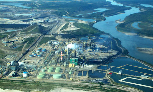
Photo by Chris Evans at The Pembina Institute.

Photo by David Dodge at The Pembina Institute.
"Not all of them would be defined as tailings ponds," said Suncor spokeswoman Kelli Stevens over the phone, "it would depend what sorts of water is in them." She could not comment on what specifically the ponds next to the Athabasca River contain.
"We're not at all new to operating in the area. We know spring runoff makes water levels rise. We are at the site constantly and monitoring for anything that isn't part of normal operations and that would obviously include anything that had to do with water from the site touching the river. That's something we would try to stay away from at all costs."

The Athabasca River is currently on a high-stream flow advisory.
The Deputy Fire Chief for the Wood Buffalo region said the Hangingstone River is higher than it has been in over a century.
"As part of our operations, we are required to keep all ponds below certain levels to ensure our ponds remain contained in these kinds of situations. We have been following that regulation, and are constantly monitoring the situation, but do not have reason for concern at this time," Suncor spokeswoman Stevens later wrote to DeSmog Canada.
The rising flood waters may pose an unprecedented threat to the region's growing tailings ponds, a number of which are located directly along the banks of the Athabasca River.
A Google Earth image, pictured right, shows the Athabasca River winding through the tar sands region and past the Suncor refining plant. The image shows the proximity of numerous tailings ponds to the river's edge.
The Alberta Environment and Sustainable Resource Development (ESRD) flood mapping tool shows the floodways surrounding Fort McMurray.

Already low-lying areas surrounding the river are suffering significant flooding.

Image from: pic.twitter.com/Jv01jj7X2W
Video from teambatesy via youtube.
Weather reports for Fort McMurray forecast rain for several more days.
