


This story is a collaboration between the Toronto Star and The Narwhal.
The Ontario government’s own research has found 11 species whose survival is in danger living along the proposed route of Highway 413 — including two central to a federal environmental review that may delay the controversial project.
According to documents obtained by The Narwhal and the Toronto Star through an access-to-information request, the Ontario Ministry of Transportation has quietly confirmed the presence of the western chorus frog, the rapids clubtail and nine other species at risk along Highway 413’s proposed route running from Vaughan through Milton in southern Ontario.
The finding raises questions about how long the proposed 60-kilometre highway might be mired in the federal review, and if Ottawa might now be compelled to formally step in and take over the project altogether.
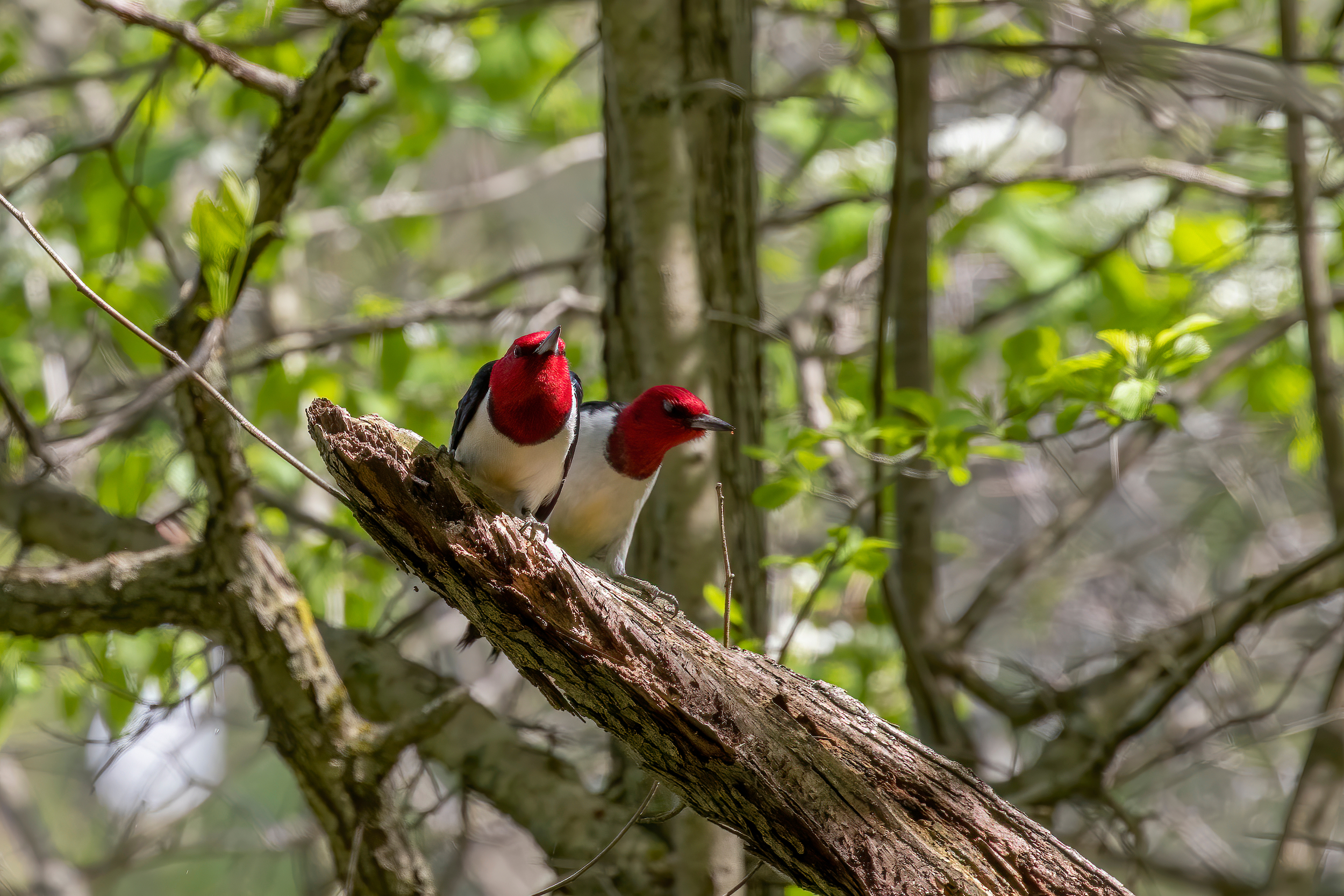
Highway 413 is a key project for the Doug Ford government, but it has been stalled since the federal government decided last year to subject it to an extra layer of environmental oversight. At the time, Ottawa said it saw “clear areas of federal concern,” especially around how the highway could harm three species at risk that were protected federally but not provincially: the western chorus frog, the red-headed woodpecker and a rare dragonfly called a rapids clubtail.
A full federal intervention could delay the highway for years, as the project would be subject to a stricter level of scrutiny.
In an email, the Impact Assessment Agency, the federal department responsible for conducting environmental assessments of certain projects, said it’s “not in a position to answer questions” about how Highway 413 could affect the environment, or whether the federal government will feel the need to take over.

But Keith Brooks, programs director at the non-profit Environmental Defence, said: “I think that the Impact Assessment Agency and [federal Environment Minister Steven] Guilbeault are going to be very hard pressed to say that a full federal impact assessment is not warranted at this point, given the information that we now know.”
Last November, Guilbeault issued an emergency order that halted work indefinitely on a residential development in Longueuil, a Montreal suburb, due to threats to the habitat of the western chorus frog in Quebec.
Ontario’s list of 11 species at risk on Highway 413’s planned route is in an internal report from October 2021 prepared by engineering consulting firms WSP and AECOM, and obtained through an access to information request to the Impact Assessment Agency. This is just an early draft — Ontario must submit a final version of the report, called an initial project description, to move the federal impact assessment process into its next phase.
“It is not unusual for a proponent to take several years to prepare an [initial project description] for a project,” said a spokesperson with the agency.
The 300-page draft report includes an update on how the project is progressing, including species observed in the area and other mandatory requirements, like consultation with Indigenous communities. The province says work is ongoing on the report, and a submission date has not been set.
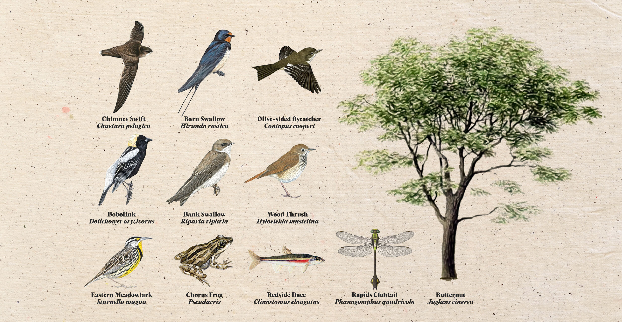
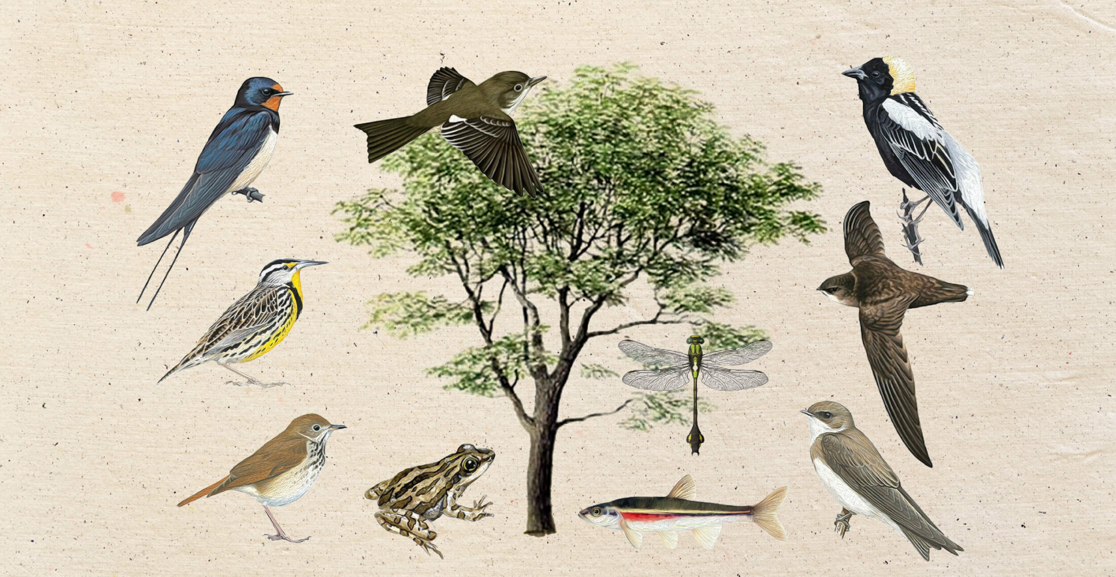
The other species at risk Ontario has observed so far include an endangered minnow called a redside dace, seven types of birds and the butternut tree. The province hasn’t yet found the red-headed woodpecker, though historical records show it might be present, the report noted. Ontario recently added the bird to its endangered species list.
Environmental groups say the further loss of species at risk is worrisome. Each part of an ecosystem plays an important role in it, and losing any of them can have unexpected consequences for human economies and culture, said Anne Bell, the director of conservation and education at Ontario Nature.
For example, the red-headed woodpecker drills holes in trees that other animals and insects use to nest, helps dead wood break down and spreads acorns and beechnuts around — all essential to maintaining the forests where they live.

“Species here are part of an interdependent fabric of life,” Bell said. “Why would we assume that we can just cut holes in life’s tapestry and unravel the threads willy nilly, with no consequences?”
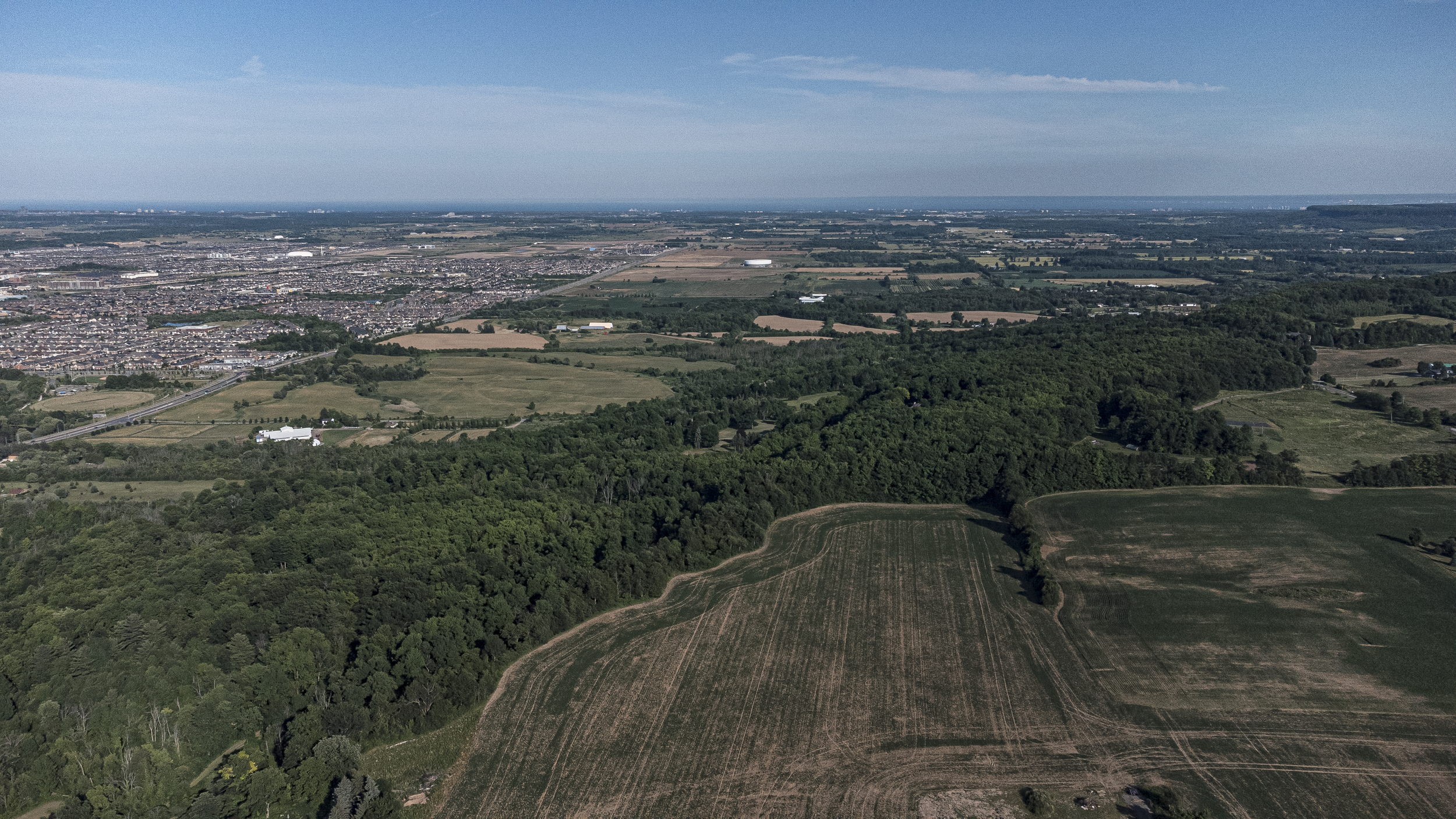
Southern Ontario marks the boundary of many species’ northern ranges, and their survival here is particularly important as climate change worsens and many plants and animals shift north to adapt. But it’s also an ongoing challenge — heavy development in the region means habitats are often scattered, disconnected patches.
Staff from the federal Impact Assessment Agency directed Ontario in November 2021 to outline how the province would minimize harm from the construction of Highway 413 to the western chorus frog, red-headed woodpecker and rapids clubtail, according to correspondence released in response to the access to information request.
More species at risk are likely near Highway 413, but exact numbers are unclear
The documents obtained by The Narwhal and The Star show the Ontario government believes that dozens more species at risk could be living along the planned route.
The documents also show it’s difficult to know the true extent of environmental damage to species along the highway route, as Ontario hasn’t finished key research. For example, the province has not yet done targeted surveys for species at risk in the area — it has fieldwork planned for summer 2022.
The report includes a longer list of 43 species at risk that the province believes may be living near the planned route of the highway. It includes the 11 confirmed species, and 31 others that historical and other records indicate might be there.
Some are plausible, but experts say some of the species on the longer list are extremely unlikely to actually be present. For example, it includes a songbird called a prothonotary warbler: as of 2005, fewer than 35 of them remained in Ontario, none in the area of Highway 413.
Fenn said the Ministry of Transportation’s species list was developed in consultation with other ministries, species at risk databases and species observed by ecologists on lands along the route. “This approach is a recognized national standard. The list has been and will be continually updated throughout the study process.”

Species at risk is a term for several categories of plants and animals in jeopardy. Endangered species are the most severe category, meaning they are in imminent risk of disappearing.
It’s common for development projects to affect one or a handful of species at risk, but Highway 413 would cover a large area and cuts through places with significant biodiversity, including Ontario’s Greenbelt.
The Ford government weakened Ontario’s species at risk rules in 2019. The new regime allows the Environment Ministry to issue permits for development that would harm endangered species habitat, as long as industry pays a fee for a fund that’s meant to help species recover elsewhere.
Last year, Ontario’s auditor general also found the Environment Ministry had never denied a permit to harm a species at risk, a problem that predates the current government.
Vaughan resident Tony Malfara, who is part of the Stop the 413 campaign, says the impact of the highway seems to get worse with each report.
“The question is why?” he said. “Especially where there are alternatives. Why are we so determined to build over and disturb an environmental ecosystem that has been built and shaped over hundreds of thousands of years? To me, it seems illogical.”