


The arrival of spring brought a surge of warm weather to Williams Lake, in the Cariboo region of B.C., and with it a rush of meltwater from the region’s snowpack. The resulting floods caused a local state of emergency, the contamination of water with sewage and the evacuation of 86 residences — a significant hardship for families given the COVID-19 pandemic.
“We haven’t really been anticipating anything like this. … So far the damage that we’ve had has been catastrophic,” Williams Lake chief administrative officer Milo Macdonald told The Narwhal.
“These are really unprecedented flows.”
The combination of warm weather and a higher-than-average snowpack in the nearby mountains serves as partial explanation for the region’s biggest flood in approximately 200 years.
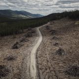
But experts say the role of wildfire, industrial logging and human development in flood-plains needs to be considered when trying to understand the cause of floods like the one in Williams Lake.
“Wildfires, forestry, urbanization — all these land uses … tend to increase flood risk,” said Sean Fleming, an adjunct professor in the department of earth, ocean and atmospheric sciences at the University of British Columbia (UBC).
Wildfires can create water-resistant soils
The Cariboo region was hit incredibly hard by record-breaking wildfires in 2017.
Twenty fires merged on the Chilcotin Plateau and covered 545,151 hectares — roughly the size of Prince Edward Island — to create the largest fire in B.C.’s recorded history.
In the area immediately surrounding Williams Lake, 31,181 hectares of land burned and caused the evacuation of the entire city. West of Williams Lake, fire near Alexis Creek covered a span of 241,160 hectares.
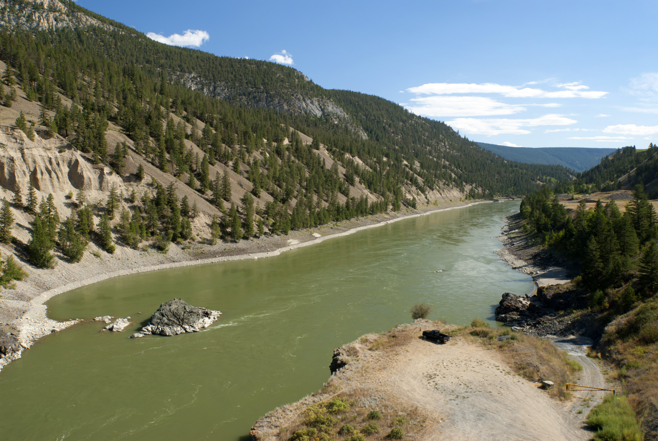
Much of this affected landscape lies in the drainage basin for the Fraser River, the country’s largest waterway flowing into the Pacific Ocean.
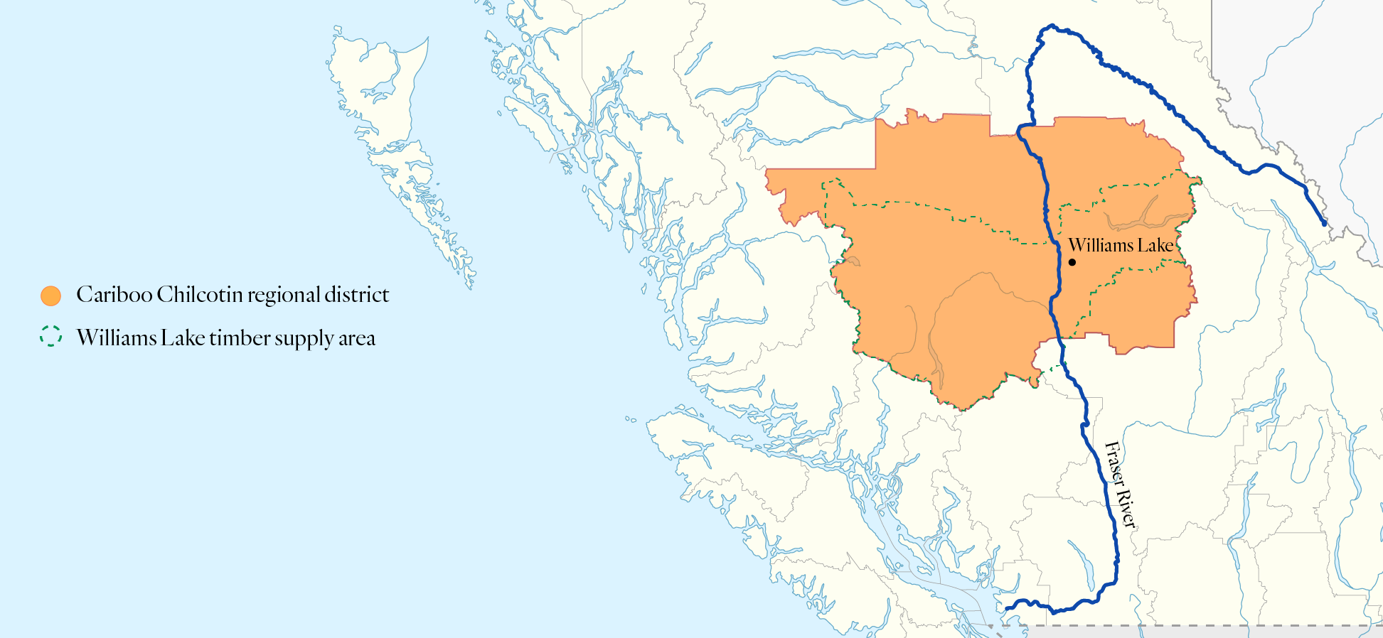
The Cariboo Chilcotin regional district. Map: Carol Linnitt / The Narwhal
According to Lori Daniels, a professor in the department of forest and conservation science at UBC, wildfires can fundamentally alter the way a landscape responds to water.
“In fires that burn really hot, it burns off all of that organic material that is mixing into the soil and it leaves behind just the mineral soil, the kind of gritty sand salts,” Daniels said. This can lead to water runoff and severe erosion.
In some cases, straw or other absorbent materials can be placed on the floor of a burned forest to help retain moisture. But the scope of the 2017 wildfire makes this solution unrealistic, Daniels said.
During wildfires, waxes and lipids from plant matter can melt and vapourize, creating a moisture-repellent layer over the forest floor that prevents water absorption. This layer can last for years. A special report prepared for the Forest Practices Board notes water-repellent conditions began to increase in the early 2000s and have contributed to numerous landslides.
“Intense wildfires that burn steep terrain, especially where soil is unstable, can decrease slope stability and increase chance of landslides,” Daniels said. Risk increases during intense rain or rapid snow melt.
“We saw these effects after the 2017 fires when intense rain saturated soils, contributing to landslides,” she said.
The 2017 Elephant Hill wildfire, which covered 192,000 hectares, was followed by spring floods and a dangerous mudslide across Highway 99 near Cache Creek that caused the disappearance of 67-year-old Valerie Morris.
Mudflows can cause debris to pile up in waterways, which can add to more flooding.
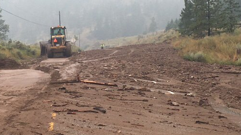
Spring floods in 2018 caused this mudslide near Cache Creek, B.C. The region was hit with a significant wildfire in the summer of 2017, which helped create the conditions for the mudslide. Photo: B.C. Transportation / Twitter
The loss of forests can also lead to an increase in snowpack, Daniels said. Branches catch snow that eventually evaporates.
For snow that does fall, the presence of forests can slow its melting. Shade from trees keeps snow cool. Without tree cover, the snowpack warms and disappears more quickly. For this reason, the loss of trees in forests where the majority of precipitation falls as snow is linked to a potential quadrupling of floods.
An increase in the pace of snow-melt can be devastating when warm spring weather meets an above-average snowpack, which happened this year in Williams Lake.
“We do know in the interior of B.C., the snowpack is really big this year … up to 35 per cent above average,” Daniels said.
But there is another twist, she added. Wildfires can lead to floods but floods, in turn, can create the conditions for more wildfires by robbing mountainsides of moisture.
“Heat in early spring contributes not only to the kind of flooding that we’re seeing, but it contributes to more enhanced risk of severe fires later in the summer,” Daniels said, adding this relationship between increased fires and increased floods is of growing concern to communities across B.C.
“Those are climate change signals that have been documented and have been traced over the last several decades.”
Deforestation adds to flood impacts
Williams Lake is also heavily reliant on forestry, and deforestation interacts with flooding in a similar way to wildfire.
“Forest management is kind of the lifeblood of [the Williams Lake] local economy and so harvesting has always been a big portion of how they manage those forests,” Daniels said.
The Williams Lake timber supply area spans across the Fraser River basin in the Cariboo region, stretching from the Coast Mountains to the Cariboo Mountains. It represents one of the largest timber supplies in the province with an annual allowable cut — the amount of timber that can be harvested in a provincially managed forest area — of three million cubic metres, roughly enough to fill roughly 75,000 standard logging trucks.
A Google Earth timelapse of Williams Lake, B.C., shows industrial development and logging on the landscape between 1984 and 2018.
The region was also affected by the mountain pine beetle epidemic, which peaked in the summer of 2005. By 2012, 86 million cubic metres of mature pine in the timber supply area had been killed by the outbreak. And while there have been few new attacks since 2009, a new pest, the Douglas-fir beetle, is considered to be a high risk to forests in the region.
According to the most recent survey in 2018, 50,254 hectares of Douglas firs in the region were affected by the beetle’s outbreak.
Daniels noted that while tree-planting efforts are in place, not enough is being done or done fast enough to replenish the forests. Young forests, she said, don’t have the rich soil or tree density of old-growth forests to protect against melting snowpack.
“We need to get the forest into a state of recovery and get that soil regenerating to build up that organic content, to get the water cycle working again.”
Risk to people living along flood zones increasing
With cooling temperatures now in the forecast, the B.C. River Forecast Centre has downgraded warnings to flood watch for waterways in the Cariboo. The state of emergency is over, but the flood’s damage is now being better understood.
Residential neighbourhoods remain abandoned. Because of eroded riverbanks, 11 facilities in the local industrial park are at risk of falling into the Williams Lake River Valley. Bridges and roads are washed out.
The community is still uncertain how the release of sewage waste is affecting water.
Willie Sellars, Elected Chief of the Williams Lake Indian Band, said he is worried about the movement of contaminated water.
“Now there’s this massive lake [in our fields] that is just dirty, dark brown water that has been coming down for the last week,” he said.
Sellars said he’s concerned the water will flow into Williams Creek, near one of the band’s reserves, and end up in the Fraser River, a key fishery for his people.
“I imagine it does have some impacts on fish habitat, plants, wildlife and how clean that water is.”
Human-made developments, such as urban centres and industrial lots, along riverbanks are pending troubles for the environment, said Fleming from UBC. When flooding causes wreckage in these areas, toxic materials from homes and properties are commonly swept into river systems and are not monitored afterward.
Ultimately rivers will run their own course and humans can’t fully control that with dams, he said.
“[Rivers] have a really important ecological role in terms of renewing flood-plains, renewing channel habitat,” Fleming said, but emphasized that when floods hit human developments, the release of contaminants into the environment becomes troublesome.
In an email to The Narwhal, a Ministry of Environment and Climate Change Strategy spokesperson wrote the impacts and volume amount of the sewage leak remain undetermined. “Untreated effluent” could be of concern, the spokesperson said, and erosion into waterways is being monitored.
The province will implement a sampling and monitoring program with the City of Williams Lake, the spokesperson added.
A new analysis by the World Resources Institute found the number of people affected by river and coastal flooding could double by 2030. That increase is driven by a combination of development in flood-plains, population growth and climate change.
There will be floods: risk could double for world’s coastal and river communities by 2030
“It’s natural that humans will want to settle along the river valleys, but what we tend to do is then want to constrain that river to our advantage,” Fin Donnelly, chair of the Rivershed Society of BC, told The Narwhal.
If communities and industry continue to cluster along rivers, flood damage will become more catastrophic, he said, adding most cities were designed decades ago, before the impact of floods and a warming climate on infrastructure was well understood. Many of these designs should be reassessed with a new understanding of the interconnection of rivers and forests, he said.
“If we start realizing these connections, we will start making better planning decisions if we all think like a watershed.”
With COVID-19 forcing some people to rethink their connection to nature, especially in the context of climate change, Donnelly said we need to take this as an opportunity to change the ways we are prepared to deal with our natural environments.
“Nature does change over time: rivers contract and expand, floods happen naturally, fires happen — this is all a system of renewal and rebirth,” he said. “We need to look at how we work within these systems as opposed to fighting and constraining them.”